We’re now in our fourth year of offering backcountry ski guidebooks in rakkup, and we are really excited about our latest feature! Slope angle shading is now available for all our US backcountry skiing guidebooks on both iOS and Android devices. Simply be sure you have our latest app release, go to the Bookshelf tab, and tap the cloud icon to update your guidebook.
Avalanche safety educators have been telling us that Slope Angle Shading is one of the best tools for visualizing areas of high avalanche hazard and selecting safer routes in avalanche terrain. This transparent overlay immediately highlights areas with slope angles yielding the highest avalanche risk along and above your route, as well as terrain convexities, terrain traps, terrain that might be too steep to ski (such as cliffs), and even very flat areas where splitboarders like us might need poles or plan on walking.
According to the American Avalanche Institute, most avalanches occur on slopes between 30° and 45°, with peak risk at 37-38°. (Watch AAI’s short video about recognizing avalanche terrain. We’re proud to partner with the AAI this season and offer rakkup guidebooks to their instructors and students.) We’ve used color gradients to show slope angle information with a high degree of precision. We applied a lot of computing power and our best programming tricks to bring you beautiful maps that are easy to download, display quickly, and keep working long after you’ve left cellular service behind.
In the past, many snow professionals used the premium versions of generic mapping apps to view slope angle shading. We think it’s even better to have this feature integrated into your guidebooks – not to mention that these apps have yearly subscription fees several times higher than our guidebook prices! Integrating all our route data with topo maps and slope angle shading helps you choose which zone and which line to ski based on today’s conditions without flipping back and forth between different sources of information.
Of course, no app can take the place of quality avalanche safety training, observation of your surroundings including terrain and snow pack, and proper decision making. But the most effective part of avalanche safety is staying out of avalanches, not digging out of them, and better information can lead to better decision-making. If rakkup can help you select a quality descent, stay alive and safe without getting lost, and have more fun away from the crowds, then we’ve accomplished what we set out to do!
We hope you’ll check out a rakkup skiing guidebook and tell us what you think. Many of our digital guidebooks are also available with a companion printed ski atlas or folding map from our friends at Beacon Guidebooks as a backup and additional reference.
Many thanks to our friend Jamie at Teton Splitboarder for encouragement and technical advice that helped us execute and improve our work.
Finally, a reminder to make sure you know how to turn off the cellular, bluetooth, and Wi-Fi radios on your phone in the backcountry and keep it at least 30 cm away from your avalanche beacon. GPS reception is a passive operation that won’t interfere with your beacon’s signal so you can still pinpoint your location with the radios off.
Happy skiing and splitboarding to everyone!
Available now for Android devices too!
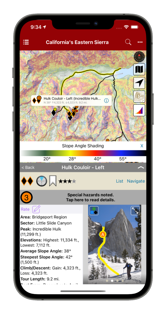
Slope Angle Shading released! was last modified: December 24th, 2020 by rob
I have lost track of how many sunrises I have seen from Berthoud Pass. This means that I have also lost count of how many dawn patrols I have had at the Pass over the years. I don’t revel in the sub-zero and pitch black starts, but the day job and family schedule dictate these early mornings. When the sun rises over the Continental Divide it sheds just enough light on the surrounding terrain. From the top of the West Side you can see the Indian Peaks to the north, and the Mount Evans Wilderness to the south. The quick access and the deep snow of Berthoud Pass provide a solace from the harsh morning, and it is the camaraderie of the skiers in the parking lot that brings the warmth. Berthoud Pass is close enough to Denver to justify several laps and then a harrowing drive down I-70 to work. I often joke that after safely navigating the hazards of backcountry skiing, the most dangerous part may be the drive back.
Friends enjoying playful terrain after a classic Colorado storm.
Backcountry skiers have been exploring Berthoud Pass for nearly one hundred years. Cars would shuttle skiers to the top of the Pass, and the pick them up at the bottom. Fast-forward to today and you can find hitchhikers on any given day at a number of trailheads. Those who are generous enough to pull over and give a hitchhiking brother or sister a ride to the top are then blessed with good karma enshrined in the history and tradition of skiing the Pass.
Berthoud Pass also has a rich lift access history. Berthoud Pass Ski Area operated discontinuously from 1937 to 2003. It was the first ski area in Colorado with a rope tow, the first two-person chair lift, and the first to allow snowboarding. The ski area also pioneered big mountain competitions in the late 1990s and early 2000s.
Scott climbing Moonlight Bowl.
Quick access, a consistent snowpack, and endless discovery continue to draw backcountry skiers to Berthoud Pass. The east to west orientation of the Pass, located high above the Fraser River and Clear Creek valleys, attracts a deep snowpack benefiting from both northwest flow and upslope storms. In just over an hour drive from Denver, backcountry skiers have access to numerous trailheads leading into the high basins surrounding the Pass. From pre-work dawn patrols, to car shuttling, to all day epics, Berthoud Pass has an adventure for backcountry riders of all skill levels. This is why I love to ski here. I hope to see you in the Pass parking lot enjoying the dawn patrol as much as I do.
Just another two foot dump and the signs are gone.
Backcountry Skiing Berthoud Pass Colorado by Rob Writz was last modified: December 8th, 2020 by FRSKIMO
Vous y découvrirez un territoire et un peuple unique qui ne laisse personne indifférent. Tous les aventuriers et explorateurs qui y sont passés en reviennent marqués. Y aller c’est s’imprégner d’une culture millénaire, c’est découvrir un territoire infini, c’est de vivre l’agréable sentiment d’isolement, d’être seul au monde et d’avoir le privilège de vivre des moments uniques, intenses, des moments WOW. En entrant en communion avec la nature, les animaux sauvages, les aurores boréales et les montagnes, on a l’impression que le monde nous appartient.
Mount Iberville south valley
Avec un peu plus de 40 lignes décrites, ce guide ne couvre qu’une infime partie de la cordillère arctique qui s’étend sur plus de 50 000 km² au nord du Labrador et du Québec, vous donnant ainsi l’opportunité de skier du terrain déjà connu et documenté, mais laissant aussi grandement place à votre imagination pour explorer l’infinité de possibilités encore intouchées. Cette chaîne de montagnes située à la frontière du Québec et du Labrador cache les plus hauts sommets du Nunavik, y compris le légendaire mont d’Iberville (Caubvick) qui se situe à cheval entre les 2 provinces. Avec son relief qui s’étend de la mer jusqu’aux pics rocheux d’où l’on peut voir la toundra s’étendre à perte de vue, ce territoire peu connu mérite le déplacement.
Jacob Laliberté bootpacking Sun In the Bucket
Il renferme une infinité d’options skiables pour tous les types de skieurs avec des dénivelés atteignant près de 1000m de vertical, des angles de pentes allant de 20º à 50º, des couloirs, des bols, des sommets et des faces de tous genres. Sans oublier les refuges (camps, dômes, tentes arctiques) situés un peu partout sur le territoire qui rendre l’expérience encore plus agréable et accessible.
Ce guide app vous donnera non seulement beaucoup d’information sur le terrain skiable. Il vous facilitera aussi la vie en vous donnant accès à toute l’information nécessaire sur; comment s’y rendre, comment économiser sur le transport, comment vous déplacer sur le territoire, où dormir et quel matériel apporter, vous permettant ainsi de vivre une expérience inoubliable sans trop vous casser le caillou. Le terrain skiable restant au cœur du guide, vous y trouverez le niveau de difficulté de chaque descente, leur niveau de risque, leur qualité (nombre d’étoiles), leur orientation, l’angle de pente, leur approche, leur description générale ainsi qu’une tonne de photos pour chacune des lignes skiables, vous donnant ainsi une bonne idée de la descente avant même de l’avoir skiée. Et pour ceux qui ont encore plus la fibre aventurière et qui ont envie de découvrir les dizaines de milliers de kilomètres carrés encore jamais explorés, alors ne vous en faites pas, il y a en masse de terrain pour combler tout le monde. Le seul conseil que nous avons à vous donner, c’est que peu importe que vous achetiez cette application ou non, ALLEZ-Y, foncez! Vous ne reviendrez pas déçu. Mais si vous n’avez pas envie de chercher de l’information à gauche et à droite, alors voici votre solution; «Backcountry skiing : NUNAVIK & LABRADOR » permet de contenir tout à la même place; autant pour la planification du voyage que pour l’auto-guidage une fois sur place.
Jacob Laliberté charging on Jesus On the Edge aka J.O.E
Bref, skier au milieu des aurores boréales et des caribous n’aura jamais été aussi accessible. «Backcountry skiing : NUNAVIK & LABRADOR» est un nouveau souffle pour l’exploration en ski et une aventure qui changera votre vie.
———————————
“Backcountry skiing: NUNAVIK & LABRADOR” is the first collection of ski runs covering the aera of Kuururjuaq Park and the Torngat Mountains Park located north of the 58th parallel.
Jacob Laliberté enjoying the light on Mirador with the Butt Crack in the background
You will discover a territory and unique people that leaves no one indifferent. All the adventurers and explorers who went up north came back marked. Travelling there is immersing yourself in a thousand-year-old culture, discovering a limitless territory, it’s living the pleasant feeling of isolation, feeling the loneliness and having the privilege of living a unique and intense moment! You and nature will make one by rubbing wild animals, aurora borealis and mountains. You’ll have the impression that the world belongs to you.
With a little more than 40 lines described, this guide-app covers only a tiny part of the Arctic Cordillera stretching over more than 50,000 km² in northern Labrador and Quebec, giving you the opportunity to ski the land already known and documented, but also leaving room for your imagination to explore the incredible amount of possibilities still untouched. This mountain range on the border of Quebec and Labrador hides the highest peaks of Nunavik, including the legendary Mount Iberville (Caubvick) which straddles the two provinces, with its relief that stretches from the sea to the rocky peaks where you can see the tundra extend as far as the eye can see. This little-known territory deserves a trip.
Bruno-Pierre Couture et Jacob Laliberté the two authors of the guide-app
It contains endless ski options for all types of skiers with vertical elevation up to 1000m, slope angles from 20º to 50º, couloirs, bowls and faces of all kinds. And that’s without counting all the shelters (camps, domes, arctic tents) located throughout the area that makes the experience even more enjoyable and accessible.
Bruno-Pierre Couture au campement sur la rivière Koroc secteur In Your Face derrière – at the camp on the Koroc river sector In your face in the back
This guide-app will not only give you information on the ski terrain. It will also make your life easier by giving you access to all the necessary information about; how to get there, how to save money on transportation, how to get around the area, where to sleep and what equipment to bring, allowing you to live an unforgettable experience without any headache. The ski area remaining the guide’s heart, you will find the level of difficulty, level of risk, quality (number of stars), orientation, slope angle, approach, a general description and a ton of photos for each of the ski lines, giving you a good idea of the descent before skiing it. And for those of you who feels more adventurous, there is still thousand and thousand of square kilometers to explore. So don’t worry, there is plenty of terrain make everyone happy. The only advice we have to give you is that whether you buy this application or not, GO FOR IT! You will not be disappointed. But if you don’t want to lose energy gathering information everywhere, then here is your solution; “Backcountry skiing: NUNAVIK & LABRADOR” put everything in one place; from the planning of your trip to the self-guiding once you’re on the spot.
In short, skiing in the middle of the northern lights and caribous will have never been so accessible. “Backcountry skiing: NUNAVIK & LABRADOR” is a new breath for skiing exploration and an adventure that will change your life.
In January of 2017, it began snowing in the Elk Mountain. A month later, it felt like it had never stopped. A long sequence of storm cycles had deposited over 10 feet of snow at Irwin, just outside of Crested Butte.
Skier Gail Sovick heads-up the front side of Snodgrass mid storm.
For backcountry skiers, a massive amount of snow in a short amount of time awakes a mixed bag of emotions. On the one hand, a skier cannot help but get excited about deep, deep pow. Images start appearing in our heads (and on our social media) of skiers porpoising way down into the white room, gloves and poles barely exposed above the surface as if they are the only way to catch a breath of air on behalf of the submerged powderhound. On the other hand, a lot of snow in a short amount of time means that avalanche danger is likely to rise, thus keeping us from venturing out into the steep-and-deep to realize our dreams of flying through the subnivean zone.
An impressive amount of snow blankets a “light tour” in the Anthracite Range
During this storm, I stopped into Wild Snow Headquarters to talk about a new book that my publishing company had just released for backcountry skiing Snoqualmie Pass in Washington. Lou Dawson runs wildsnow.com, which is one of the best online stops for quality and comprehensive backcountry ski news. Being the warm welcoming guy that he is, he invited me in for a cup of coffee, where we proceeded to talk about the storm that was surrounding our beloved mountains. We began talking about what we typically do during storms like this. Many people will read the avalanche forecast during storms like this, see that the danger is very elevated, and they will simply go to the ski area or just stay home. But backcountry skiers like Lou see things a little different. They begin to look for slopes in their area that are too low-angle to slide, but still steep enough to get some slow, yet oh-so enjoyable, turns on the way down.
Lou and I began talking about these tours and how wonderful they are, not only for high-danger days, but also for days with novice friends, or quick before-work tours, or days when you’re nursing a pulled muscle. In our conversation, we soon came to realize that we don’t even need an excuse to go hit the “light tours” of our area…we just plain like them. Our conclusion was that it’s really good to have a list of your local light tours in the back of your mind when the context presents itself.
Skier Gail Sovick takes a meadow break in Crested Butte’s Red Lady Glades.
So was born, the idea of creating a book that showcases some of our state’s light tours. It is said Colorado has 300 sunny days a year. Combine that with several thousand mountains, and a winter climate that’s downright temperate. The result: one of the best places on the planet for ski touring. Of course nothing is perfect. Colorado challenges backcountry skiers with limited public access options, due in part to it being a mostly rural, relatively un-roaded western state. More importantly, due to various climatic factors the state’s mountains can be prone to dangerous avalanches for much of every winter. Yet options exist. Key with backcountry travel is picking routes with lower angle pitches and other avalanche-mitigating factors. While these “light tours” are surprisingly difficult to find, they do exist. We detail a selection of Colorado’s best under these covers. Further, a growing trend in ski touring is the use of ski resorts for “uphilling,” motivated by the need for a less committing experience — yet nonetheless an experience that can equal any other outdoor sport in enjoyment. Colorado lends itself to this as well, with most of the state’s more than twenty ski resorts allowing uphill skiing. Thus, we offer a special mix here, combining a variety of “easy” backcountry routes with recommended resort options. Pick one of our many days of Colorado sunshine, get out and enjoy.
Uphill Skiing and Light Tours of Colorado by Andy Sovick & Lou Dawson was last modified: December 9th, 2020 by worker
How does a solid 7500 vertical foot ski descent from the top of a steaming volcano, with views of Canada, the San Juan Islands, and the heart of the North Cascades sound? If this sounds like your kind of thing, Mount Baker is your kind of mountain. Mount Baker, originally known to the Lummi as Komo Kulshan, aka the White Sentinel, was first sighted by the Spanish in 1790. 2 years later Captain George Vancouver discovered passage into the Salish Sea and the great renaming began with giving Kulshan the name: Mount Baker, after his lieutenant Joseph Baker who was the first of his crew to spot the volcano. Locals discovered powder skiing in 1927 and the ski area opened in 1929.
Climbers heading for Baker’s summit
The first uninterrupted climb and ski descent was achieved in 1933 by Hans Otto Giese and Don Fraser of the Seattle Ski Club. Apparently, they summited in 6.5 hours, and descended 6,750 feet in 30 minutes. Looking back on the particular gear they must have been climbing and skiing with, it is certainly humbling to think of the challenges men like these had to face in order to accomplish such high adventure with success. 90 years later passion to ride now is shared from Vancouver BC to Seattle driving up hwy 542 every weekend from November thru April to ride the biggest storms in the NW!
Ptarmigan Ridge beckons those looking to reach a little farther
The Mt. Baker backcountry extends east to west from Mt. Shuksan to Mt. Baker connecting ridges of Shuksan Arm to Ptarmigan Ridge with expansive glaciers, powder bowls, technical couloirs, powder-filled glades and plenty of lower elevation trees. Many ski routes begin directly from the Mt. Baker Ski Area averaging the deepest snowpack in North America guaranteeing you can find fresh tracks somewhere.
The terrain found on the north face of Shuksan certainly demands respect
What is one part of the avalanche recipe that never changes? Terrain. Terrain is the only constant. With Backcountry Skiing Mount Baker and Rakkup’s powerful planning and execution tools, you can read your run the night, week, or month before. Refer to it as you travel through the field, assess your conditions, and adjust your plan as necessary.
Backcountry Skiing Mt. Baker by Matt Schonwald was last modified: December 9th, 2020 by mattschonwald
December, 2000: I was a freshman at Fort Lewis College in Durango, sitting in a van full of other new students. The van was doggedly climbing up Coal Bank Pass towards Silverton, Colorado. I had applied to Fort Lewis for two reasons. 1) It had an excellent humanities department, and 2) it is at the foot of the San Juan Mountains, home of backcountry ski legends. Legendary backcountry pioneers like Dolores LaChappelle and Chris Landry made their homes in the San Juans. Legendary big steep mountains like Snowdon, Bear, Sultan and Kendall loom over the towns and highways like sentinels of a sacred place. Yes, I wanted to get a college education, but let’s be serious for a minute: I was a 19 year-old kid hungry for epic adventures and boundary-pushing weekends.
Skier Kevin Krill finds a natural terrain park
This was my place. The van full of students parked at the top of Molas Pass where we all stepped out, trying not to let our dropped jaws show too much as to make us look un-cool (we were 19 years old after all). We were on an Outdoor Pursuits day-trip, led by two very knowledgeable outdoorsmen. The class was titled “Terrain and Route Finding in Avalanche Country”. The instructors’ goal was to give us kids a primer on how to view avalanche terrain, how to notice avalanche prone features, how to understand the way an avalanche will move down different types of terrain. All day, we drove and hiked to dozens of locations to see classic ski zones like Anvil, Red 3, Kendall, and Prospect where the instructors emphasized how important it is to inspect avalanche terrain, plan your routes up and down. I’ll never forget the part of the day when our instructor said the following: “It would be so cool to have a folder full of photos of all the runs you want to ski, so that you can use them as you plan your next tour. From this moment, deep in the best ski terrain of the San Juans, the idea was born to create a terrain based photographic atlas of all backcountry runs.
I believe that just as a kayaker scouts his run and commits it to memory, a backcountry skier should too. Smack-dab in the center of an ancient volcanic caldera, Silverton is a true mountain town. Home to an extreme ski resort, famous mountaineers, miners and rich history, it is a fantastic place to visit and speaks for itself when it comes to remote and rugged towns. Many mountain ranges don’t have a year-round maintained road passing through them. The San Juan Range from Durango, through Silverton, to Ouray has three: Coal Bank, Molas, and the infamous Red Mountain. Highway 550 brings powder-hounds through some of Colorado’s most rugged and diverse ski terrain. Silverton Mountain ski resort, at the heart of the San Juans, boasts an annual snowfall of 400 inches. What is one part of the avalanche recipe that never changes? Terrain. Terrain is the only constant. With Backcountry Skiing Silverton and rakkup’s powerful planning and execution tools, you can read your run the night, week, or month before. You can refer to it as you travel through the field, assess your conditions, and adjust your plan as necessary.
Over here at rakkup “World Headquarters”, our homes in Seattle, we are climbers and we love climbing. But like many climbers, we live near the mountains and love playing in them in a variety of ways, and we have winters to get through. And in the Pacific Northwest, we have plenty of precipitation which turns into an amazing amount of snow at elevation.
Early Days – transitioning on a Voilé split, 2005
So, it’s only natural that Rob and Todd love to get out on the snow. While we both have skiing in our history, we’ve become pretty hooked on snowboarding. We can even claim to be pretty early splitboarders; here you can see a picture of Rob starting a transition in the Herman Saddle zone near Mount Baker in the winter of 2004-2005. What we can’t claim to be is snow experts. In December of 2005, we managed to demonstrate our lack of expertise by spending an unplanned overnight near Stevens Pass. (That epic led to our first purchase of a GPS, which eventually became the very unit we used to make the first rakkup rock climbing guidebook!)
We have had friends tell us for years that our app would be a great fit for backcountry snow. In the last year, two pieces came together to make that idea irresistible to us. The first is that our awesome partner, Wolverine Publishing, told us about the success and the quality of their guidebook Backcountry Skiing California’s Eastern Sierra. The book’s author, Nate Greenberg, was interested in the potential of his content combined with an app, too.
Meanwhile, Rob had taken a couple of snowboarding trips to different zones in Alaska, with Jamie Weeks as his guide. As Rob and Jamie became friends, Jamie wondered aloud about what a great guidebook app would look like for the ski terrain near his home in Jackson Hole, and expressed some enthusiasm for the project.
Jamie Weeks doing the guide thing in AK
Nate is the director of the Eastern Sierra Avalanche Center, and Jamie is an AMGA certified snow guide and avalanche educator, well known for his work as Teton Splitboarder. What Rob and Todd lacked in experience and technical expertise, they now had in their partners. All four shared a passion for the project.
Together we bring you the newest update to rakkup, and our first two guidebooks for backcountry skiers and snowboarders: Teton Pass Descents and Backcountry Skiing California’s Eastern Sierra, a digital enhancement to the existing print title from Wolverine Publishing.
Lots of work went into developing guidebooks that are clear and easy to read, with symbology and maps that let you browse and choose quickly. We added topo maps with contour lines, a necessity in ski terrain. We are especially proud of our filtering feature that lets you apply criteria from your local avalanche center to eliminate runs in higher-risk terrain based on slope angle, aspect, and elevation and choose from the runs that remain.
Best of all: Search for terrain, or Filter based on critical information factors (like those presented in an avalanche advisory).
We’ve already been told that this app is the most compelling and exciting backcountry ski app yet. Yet we know that this is just a beginning. For one, we have many more guidebooks already in the works, from respected and talented authors all over. (We are always looking for more! Let us know if you want to write a guidebook.) Secondly, we have plans we think you will love, from sharing your adventures with friends, to visualizing the latest reports and information to keep safe. We’ll be adding features to make this app a tool you won’t want to head into the backcountry without!
So, get out there and shred your own patch of pow! Give one of our guidebooks a spin and tell us what you think.
-Rob, Todd, Nate, and Jamie
Backcountry Skiing and Snowboarding — a new adventure for rakkup was last modified: September 25th, 2017 by rob