by todd | Aug 3, 2022
Backcountry Skiing: Rocky Mountain National Park Colorado
by Mike Soucy
Colorado Avalanche Information Center
Beacon Guidebooks:
California: Tahoe Light Tours Colorado: Berthoud Pass | Buffalo | Cameron | CO Light Tours | Crested Butte | Loveland | Marble | Silverton New Mexico: Taos Oregon: Hood Washington: Baker | Crystal | ONP | Snoqualmie | Stevens
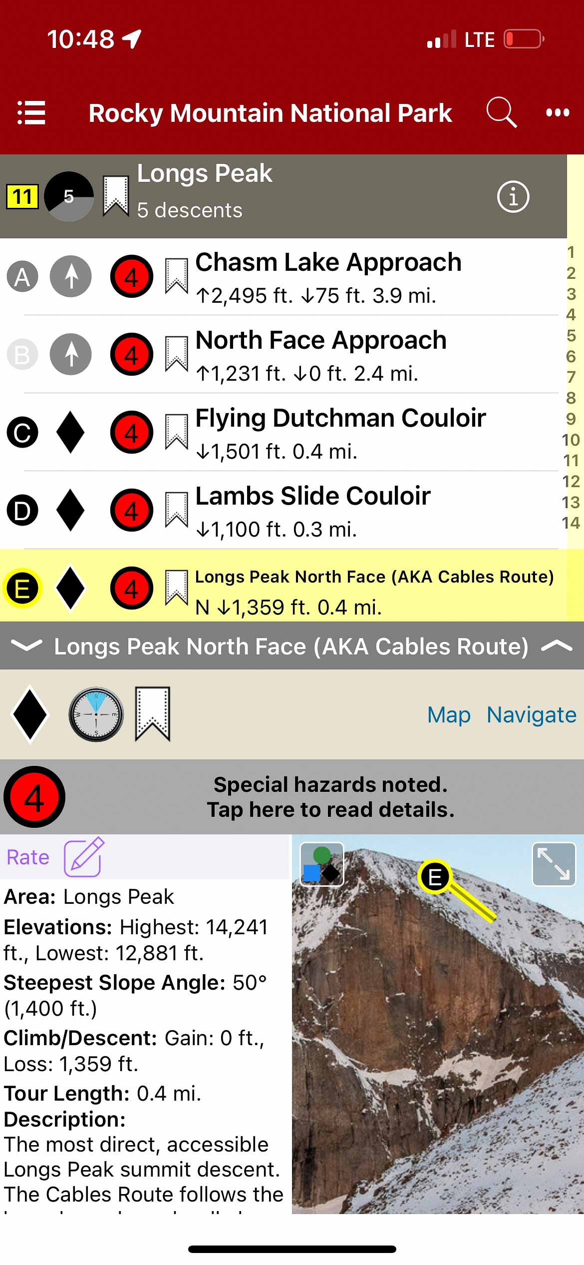
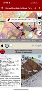
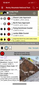
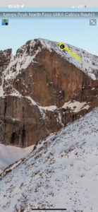
“The Park,” as locals know it, is home to some of the most diverse, accessible ski terrain on the Colorado Front Range. The Continental Divide creates a North-South backbone through the Park, and the glacier-carved east side offers long valleys of leeward terrain all the way to timberline. The Park holds the highest concentration of ski mountaineering terrain in the Front Range. Steep, dramatic scenery awaits as soon as you break into the alpine. Here, you will find options from entry-level to expert, from couloirs to alpine bowls. When the challenging midwinter weather or shallow early-season snowpack keeps you below the Continental Divide, fear not. Near- and below-timberline glades and gullies offer adventures in every valley, limited only by your curiosity for exploration. If you’re up for a more social affair, take a lap or two at Hidden Valley, a now-defunct ski area (1955–1991) which has become a gathering spot for everyone from new visitors and families to locals and skimo trainers. The spring months bring a deeper snowpack, more favorable weather, and the opening of Trail Ridge Road, which happens on Memorial Day Weekend in typical snow years. Topping out at over 12,000’, this is the highest paved road in Colorado and gives spring and early summer skiers great access to high alpine terrain. Mount Cumulus, Flattop Mountain, Hallett Peak, Longs Peak, McHenrys Peak, and many others offer classic high summit ski descents for a range of ability levels. April and May are often prime months for these objectives; you can still ski from the parking lot and often have the choice between cold snow or corn. In this first edition, we’ve compiled a list of the classic tours and descents the Park is known for, and included a few lesser-known objectives to spark the veterans’ curiosity. Routes and descriptions have been ground-truthed, vetted for accuracy, and supported by photography in order to provide a reliable planning and decision-making tool for your adventures. Enjoy!
The author and publisher acknowledge that the land described in this atlas is the ancestral home of the Hinono’eiteen (Arapaho) and Núutsi-u (Ute) peoples, who lived on these lands for thousands of years before the arrival of Europeans. The Arapaho traveled from the plains to and from what is now the east side of RMNP, while the Ute tribe lived along the west side and around what is now Grand Lake. They would also make seasonal trips back to the plains, traveling over the Continental Divide using what we now call the Ute Trail. Oliver Toll’s Arapaho Names and Trails is a great resource for learning more about the history of this land.
-
-
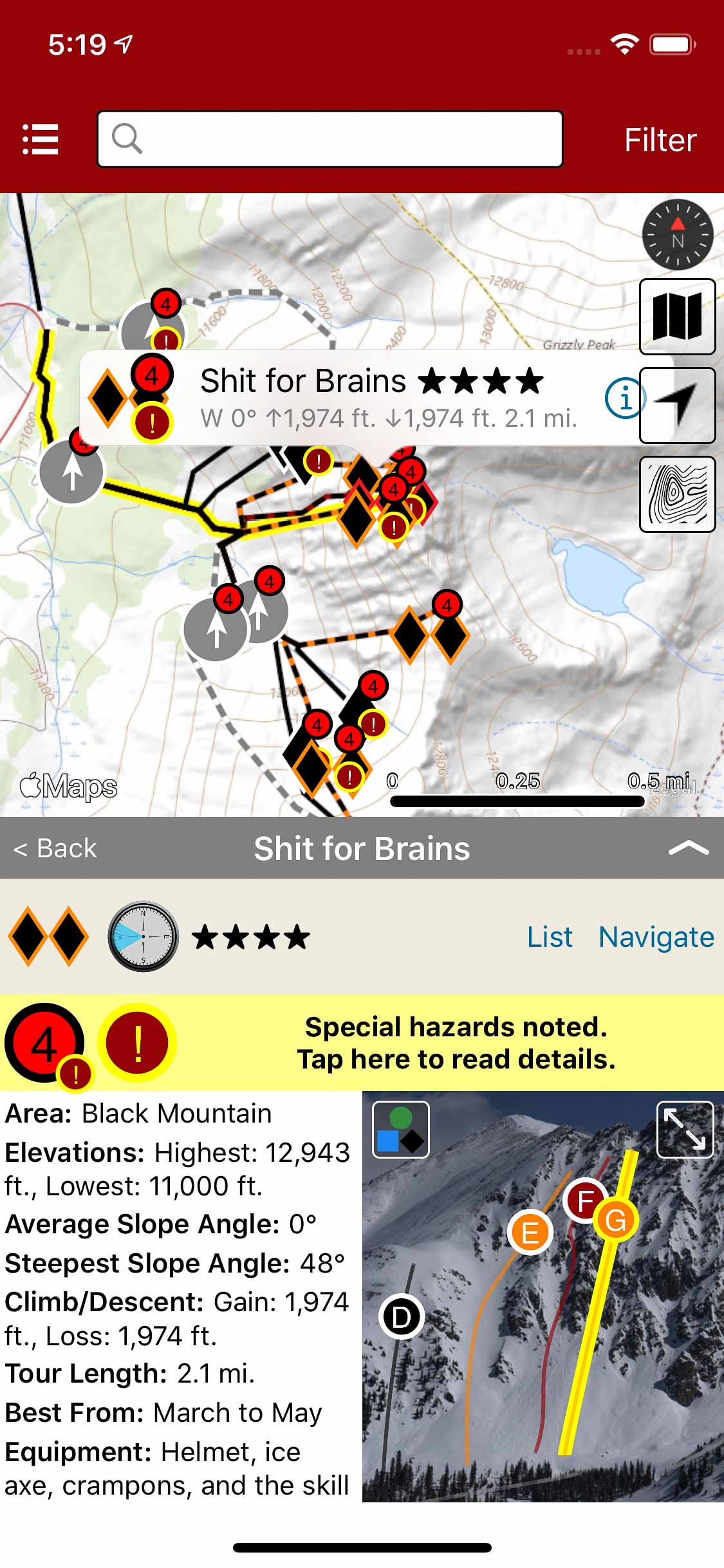
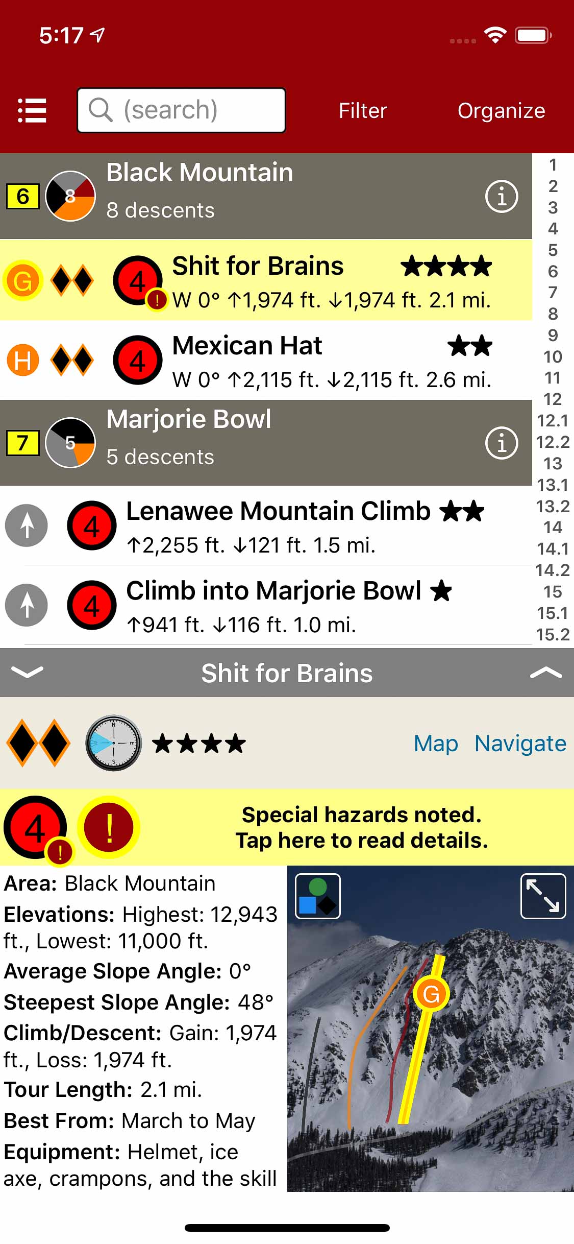
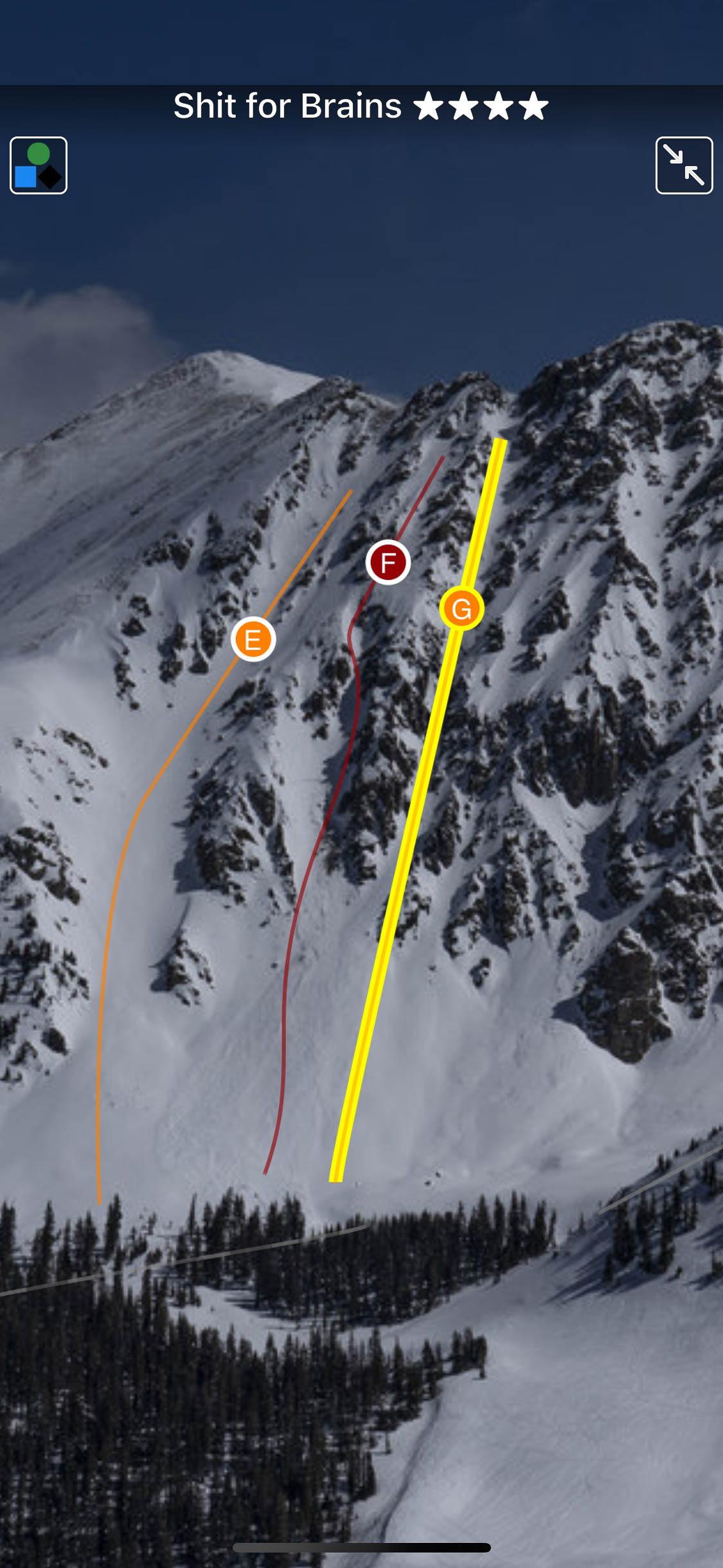
Map view
-
-
List view
-
-
Full screen photos
by todd | Nov 9, 2021
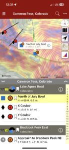
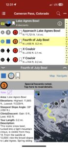
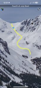
Backcountry Skiing: Cameron Pass, Colorado
by Rodney Ley
Colorado Avalanche Information Center
Beacon Guidebooks:
California: Tahoe Light Tours Colorado: Berthoud Pass | Buffalo | CO Light Tours | Crested Butte | Loveland | Marble | RMNP | Silverton Oregon: Hood Washington: Baker | Crystal | ONP | Snoqualmie | Stevens
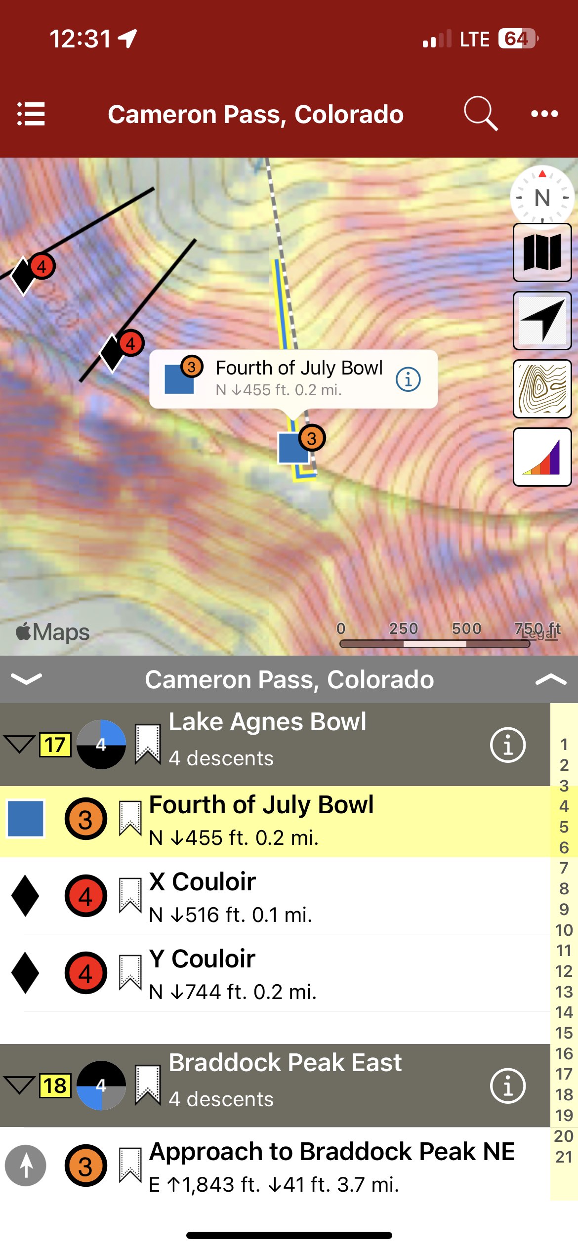
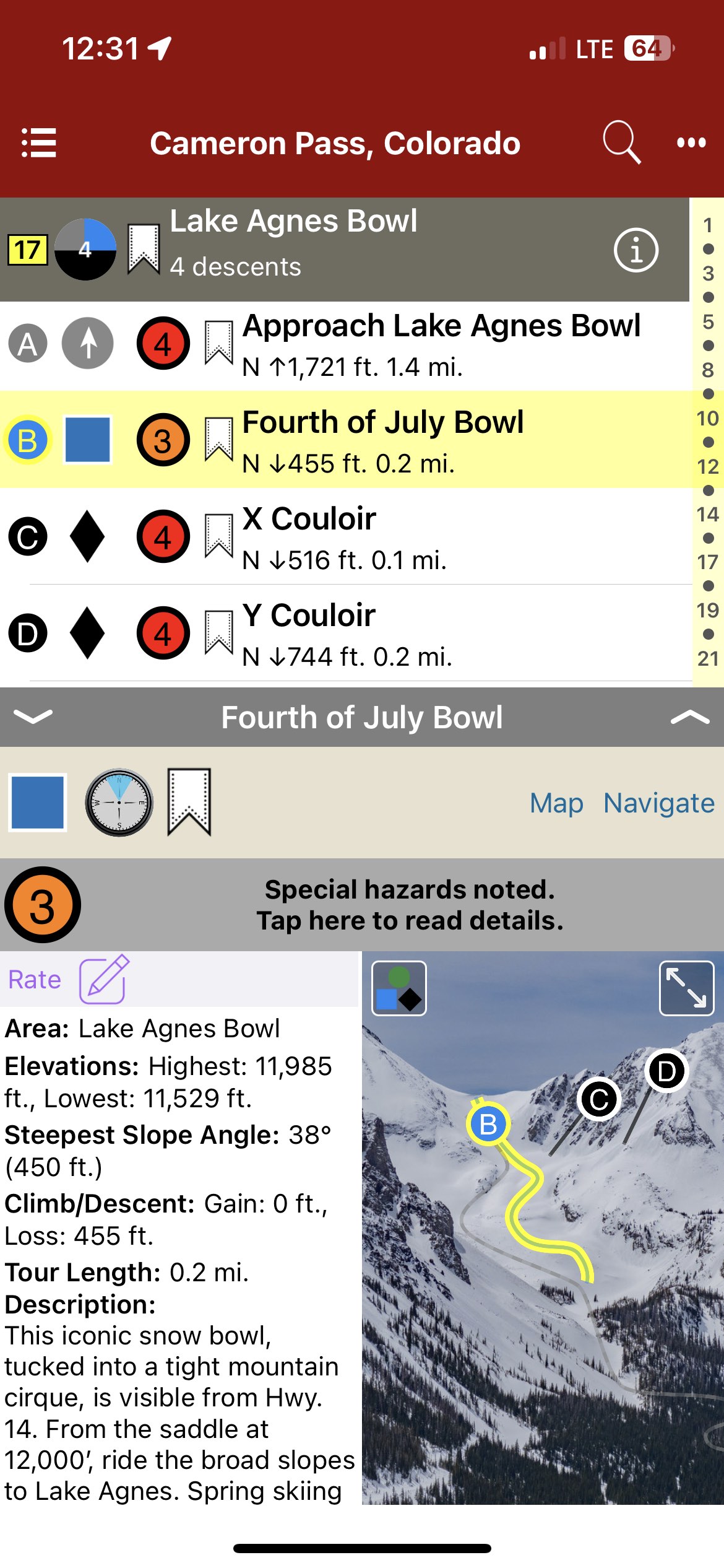
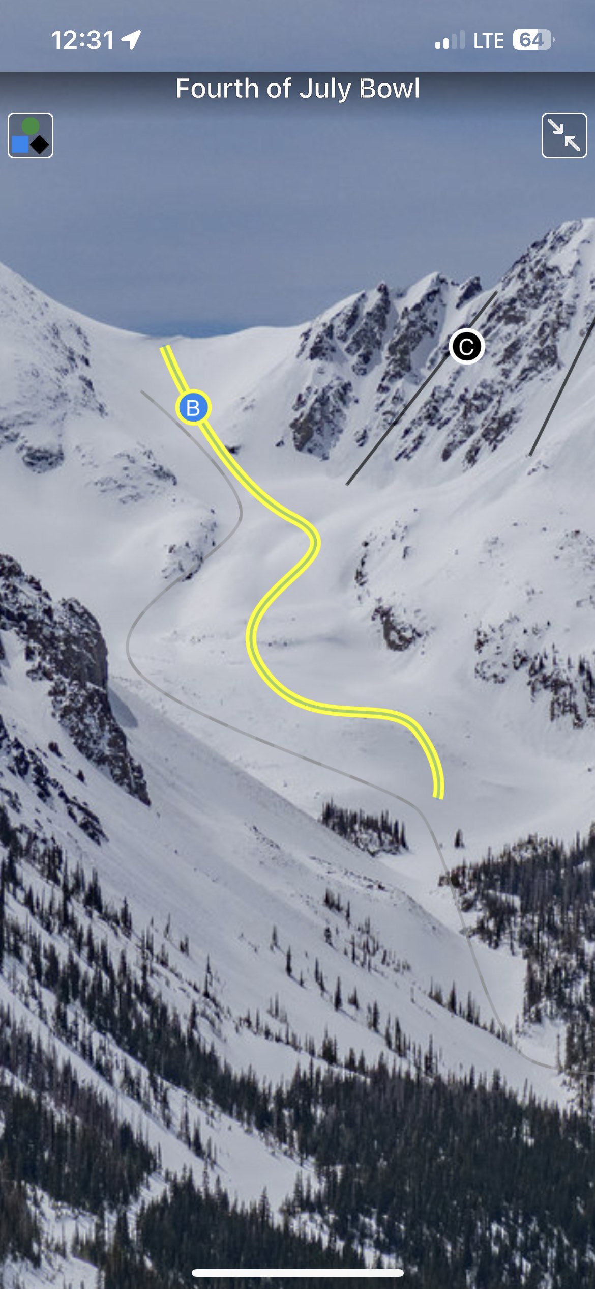
Cameron Pass provides a unique Colorado backcountry skiing experience. Remote and undeveloped, “Cam Pass” also receives a generous amount of snow each winter; good skiing often extends into May. Colorado State Hwy.14, a well-maintained all-weather road over the pass, provides access from east and west. Although Cameron Pass does not cross the Continental Divide, it is the only year-round highway north of Berthoud Pass accessing the western slope. Just 65 miles from Fort Collins and 90 miles from Steamboat Springs, Cameron Pass is a straightforward day trip from many areas in Colorado. During the winter, facilities such as lodging, gas stations, and restaurants are scarce. Cell service on Cameron Pass is spotty to non-existent: only on higher ridges with good line of sight is cell service possible. The Moose Visitor Center, located 9 miles west of Cameron Pass, remains open year-round, providing restrooms and visitor services. At the time of publication, no wifi or cell service exists at this location. Administratively, the area is managed by Arapaho & Roosevelt National Forest east of Cameron Pass and by Colorado Parks and Wildlife (CPW) on the west side of the pass. Parking and access on the west side of the pass require a CPW Parks Permit. Currently, the National Forest does not require a daily use fee for the eastern side. The author and publisher acknowledge that the land described in this atlas is the ancestral home of the Hinono’eiteen (Arapaho) and Núutsi-u (Ute) peoples, who lived on these lands for thousands of years before the arrival of Europeans.
-
-
Map view
-
-
List view
-
-
Full screen topo photos
by todd | Mar 21, 2020
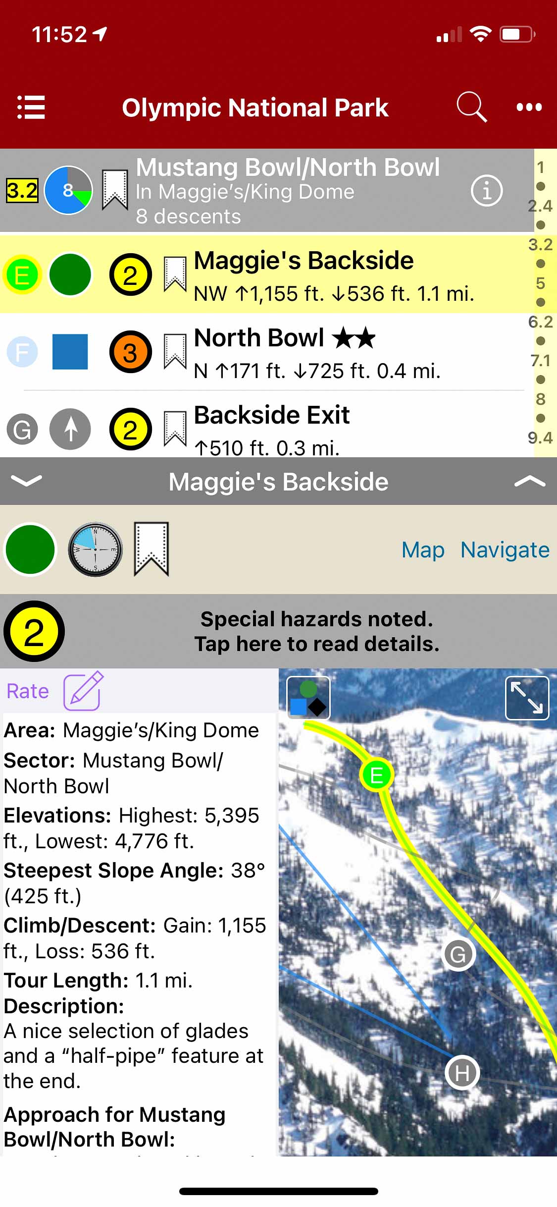
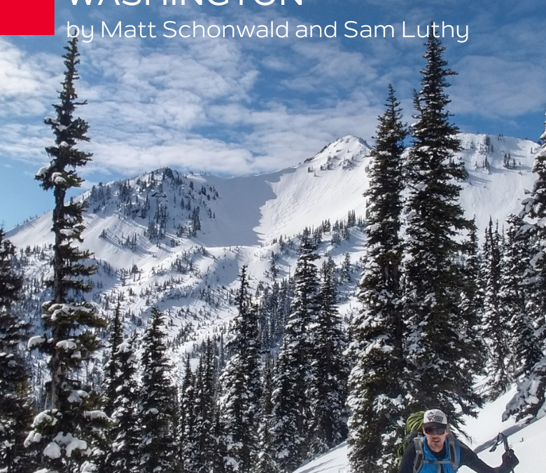
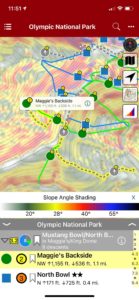
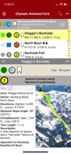
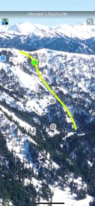
Backcountry Skiing Olympic National Park, Washington
by Matt Schonwald & Sam Luthy
Northwest Avalanche Center
Beacon Guidebooks:
California: Tahoe Light Tours Colorado: Berthoud | Buffalo | Cameron| CO Light Tours | Crested Butte | Loveland | Marble | RMNP | Silverton New Mexico: Taos Oregon: Hood Washington: Baker | Crystal | Snoqualmie | Stevens
For almost 8,000 years native people have lived around the Olympic Mountains. The Duwamish of the Salish sea call them ‘Sun-a-do’, and the ancestors of the Klallam have been living, hunting and gathering in the high mountains since time immemorial.The Spanish sailed along the coast in 1774 and named the highest peak, Cerro Nevado de Santa Rosalia. In 1788, the British Explorer Roger Meares renamed the highest peak, Mt Olympus because it looked like the ‘abode of the gods.’ and just like that the Olympic Mountains became part of the European map.The 1890s saw climbers begin ascending the summits of Mt. Olympus, with the main summit finally being climbed in 1907. Deer Park became Washington’s premier ski area in the mid 1930s. The Hurricane Ridge road was built in the early 50s and the ski area moved from Deer Park, establishing a new winter recreation center for the Olympic National Park. Ski touring began along the roads of Deer Park and Hurricane Ridge and shifted to the Bailey Range and the higher peaks in the 1990s.
Buy digital plus (book and/or map) and the price includes $4.00 for shipping, a screaming deal! When you buy a bundle, you can use your digital rakkup guidebook immediately.
-
-
Map view
-
-
List view
-
-
Full screen photos
by todd | Oct 15, 2019
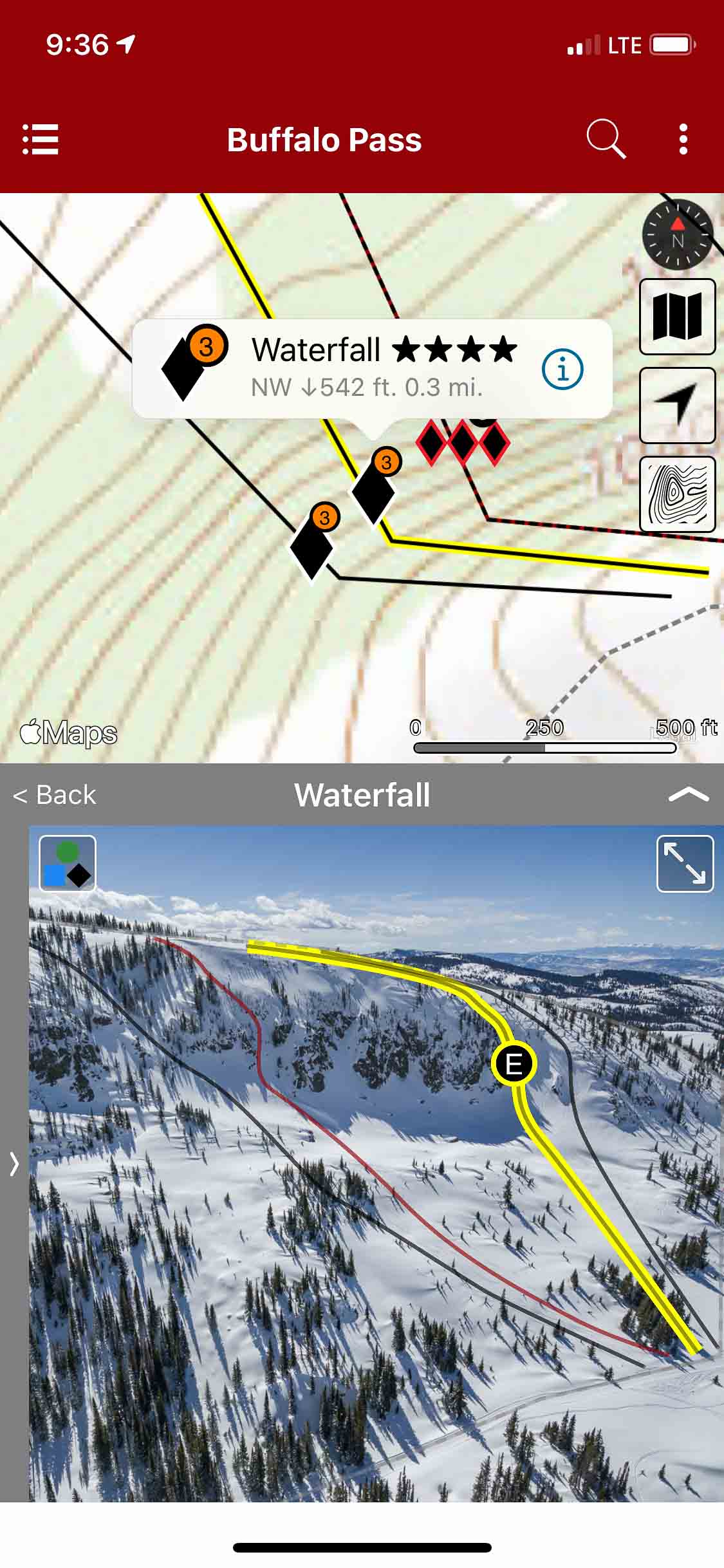
Backcountry Skiing: Buffalo Pass, Colorado
Colorado Avalanche Information Center
Beacon Guidebooks:
California: Tahoe Light Tours Colorado: Berthoud | Cameron | CO Light Tours | Crested Butte | Loveland | Marble | Silverton | Stevens New Mexico: Taos Oregon: Hood Washington: Baker | Crystal | ONP | Snoqualmie | Stevens
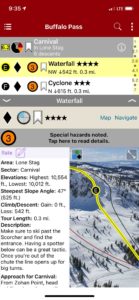
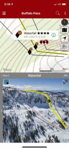
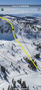
Buffalo Pass is the mecca for backcountry sled-skiers in the Rockies. Nestled in the Park Range of the Rocky Mountains near Steamboat Springs, it is one of the only places in the world where you can drive 15 minutes from a resort, unload a trailer full of snowmobiles, and have a 55-mile network of maintained snow roads on public lands dedicated to mechanized skiing from mid-December til Gaper Day.
The orientation of Buff Pass makes it favorable for significant orographic snowfall in zonal flow, particularly northwest flow patterns. The frigid air from northwest Colorado adds to the magic of “Fluffalo Pass” by providing consistent light and blower powder all winter long. To top it off, Buff Pass competes with Wolf Creek Pass every season for having the deepest snowpack in Colorado. Buffalo Pass also has access to some of the best tree skiing in the world, varying from widely spaced and naturally gladed aspens in mellow terrain to tight and technical aspens and evergreens guaranteed to test any skier.The area boasts some of the oldest and largest old growth aspens in Colorado.There are several stands on the pass that are renowned for their top to bottom skiing amongst quaking aspens such as Forester’s Aspens, Double A’s, GalaxyTrees, and Quaker Bowl. However, the gem of Buff Pass is Soda Mountain. When the skies rip to blue, locals and tourists alike flock to the highest point on the pass for steep chutes, big drops, and technical terrain in Buff Pass’s deep, world class powder.
Buy digital plus (book and/or map) and the price includes $4.00 for shipping, a screaming deal! When you buy a bundle, you can use your digital rakkup guidebook immediately.
-
-
List view
-
-
Map view
-
-
Full screen photos
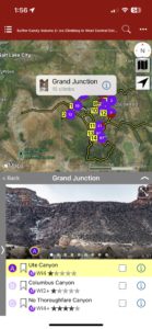
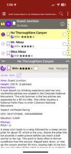
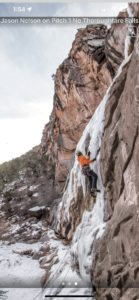
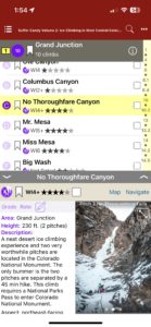
by todd | Mar 6, 2019
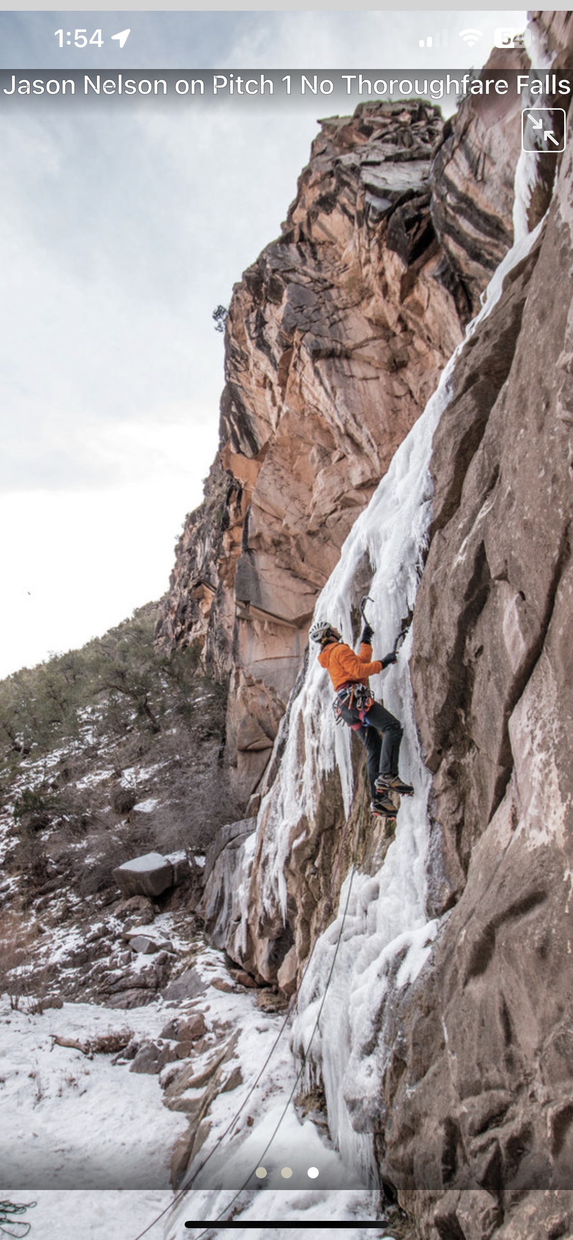
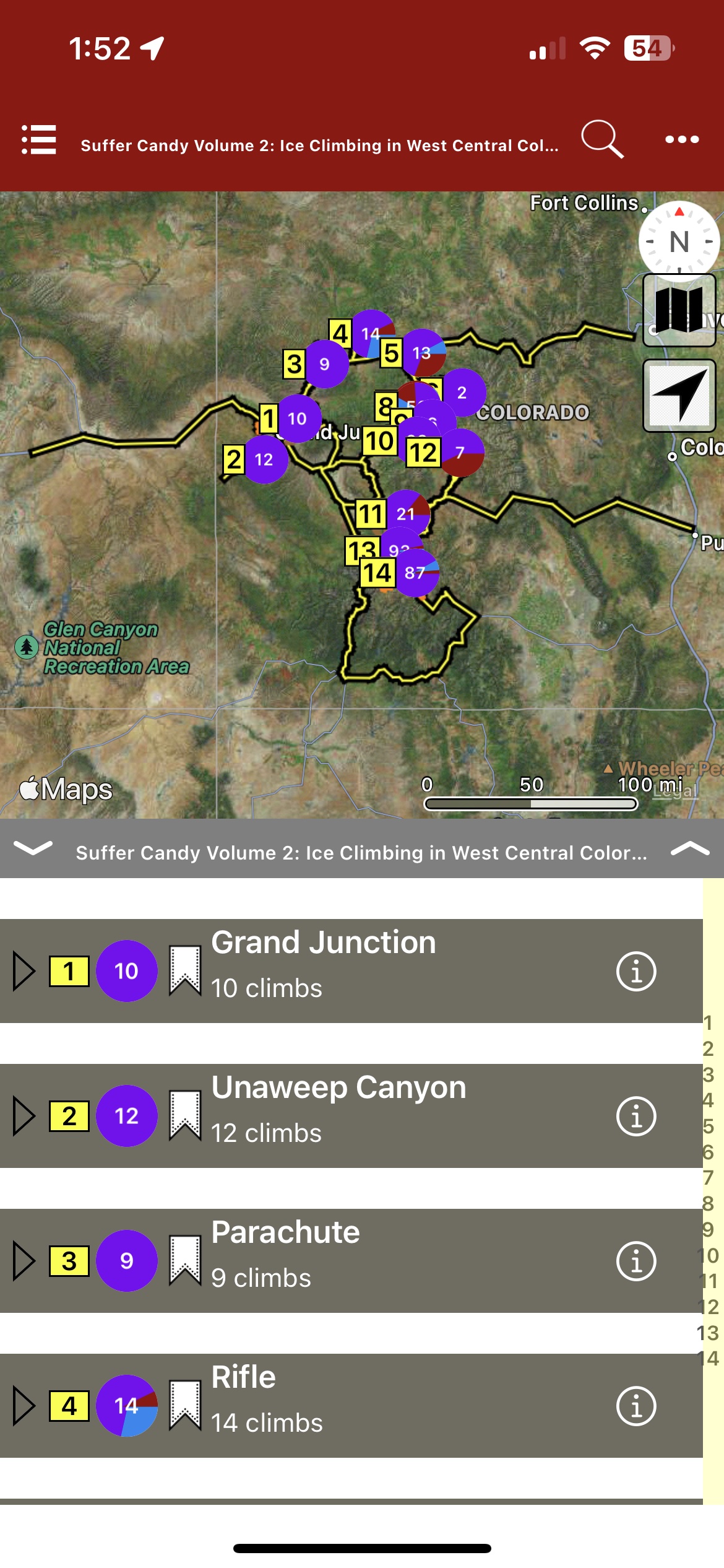
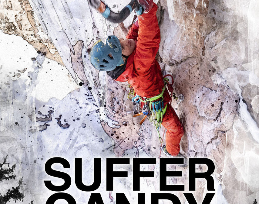
SUFFER CANDY VOLUME 2
by Jason Nelson
Visual Adventures | Suffer Candy Volume 1 | Climbs of the Million Dollar Highway
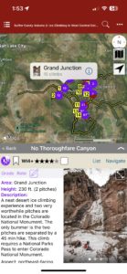
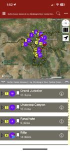
This guidebook covers ice, mixed and drytooling routes in Western Colorado. Climbs around the following locations are included; Grand Junction, Parachute, Rifle, Glenwood Springs, Aspen, Redstone, Blue Mesa, Crested Butte, Unaweep Canyon, and Lake City.
-
-
Map over Sector
-
-
LIst over description
-
-
Full screen image
-
-
List, description, image
-
-
Map, Description, Image
-
-
Map Sector
Price includes domestic US shipping for digital plus book bundle.
by todd | Jan 4, 2019
Backcountry Skiing: Loveland Pass, Colorado
by Rob Writz
Colorado Avalanche Information Center
Beacon Guidebooks:
California: Tahoe Light Tours Colorado: Berthoud | Buffalo | Cameron | CO Light Tours | Crested Butte | Marble | RMNP | Silverton New Mexico: Taos Oregon: Hood Washington: Baker | Crystal | ONP | Snoqualmie | Stevens
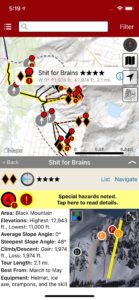
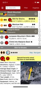
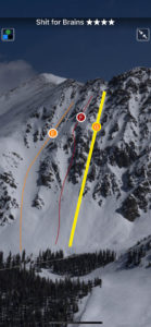
Join us this winter to unlock new terrain on Loveland Pass. From Watrous Gulch to Porcupine Gulch, we follow US Highway 6 as it climbs dramatically to 11,990 feet; providing trailhead access to glacial valleys holding a lifetime of winter backcountry exploration. Download the Loveland Pass guidebook to get access to 23 zones and 165 named runs. Featuring ascent routes, descent descriptions, max slope angles, a trail map, offline GPS navigation and much more, this app helps your terrain management, tour planning and route finding. Check out the new foldable, waterproof trail map from Beacon Guidebooks too!
Buy digital plus (book and/or map ) and the price includes $4.00 for shipping, a screaming deal! When you buy a bundle, you can use your digital rakkup guidebook immediately.
-
-
Map view
-
-
List view
-
-
Full screen photos
by todd | Nov 28, 2018
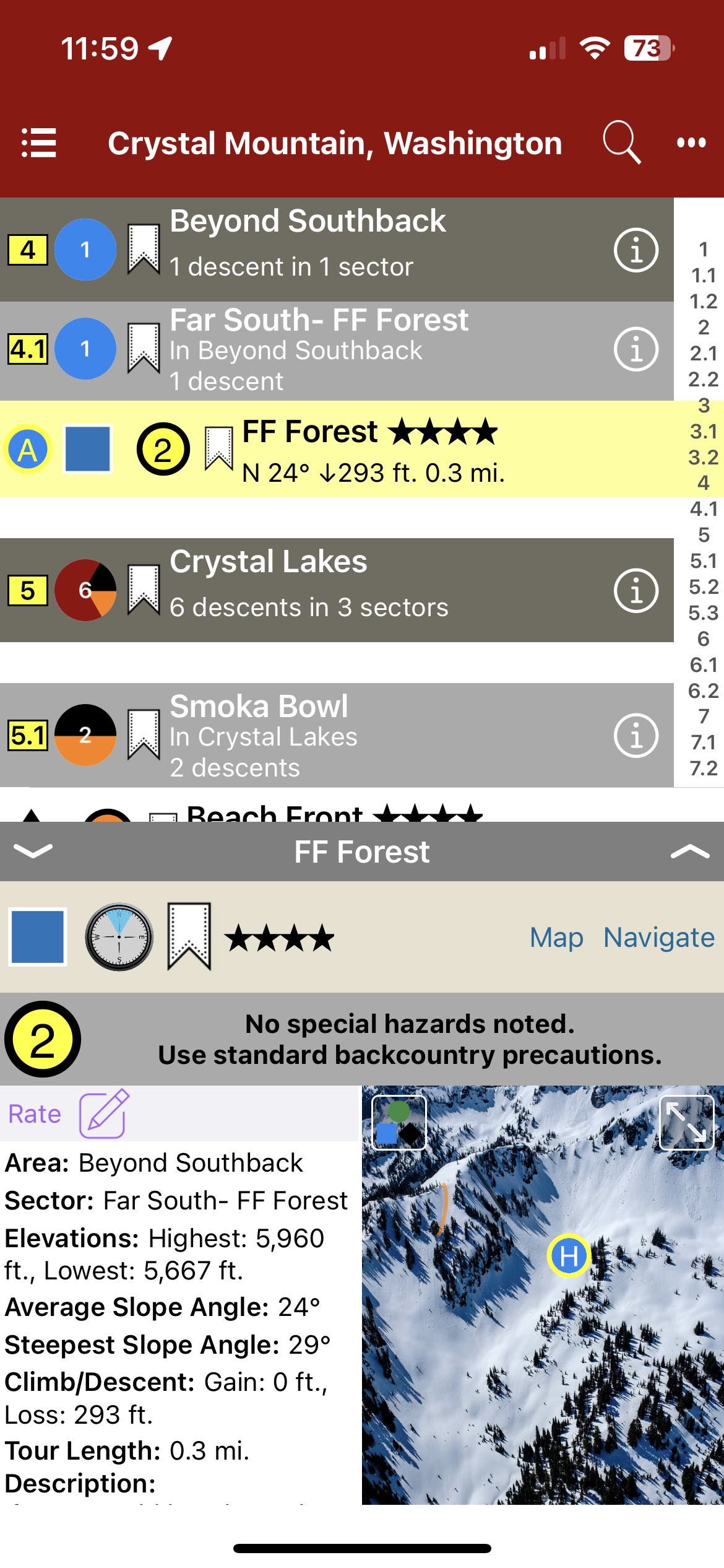
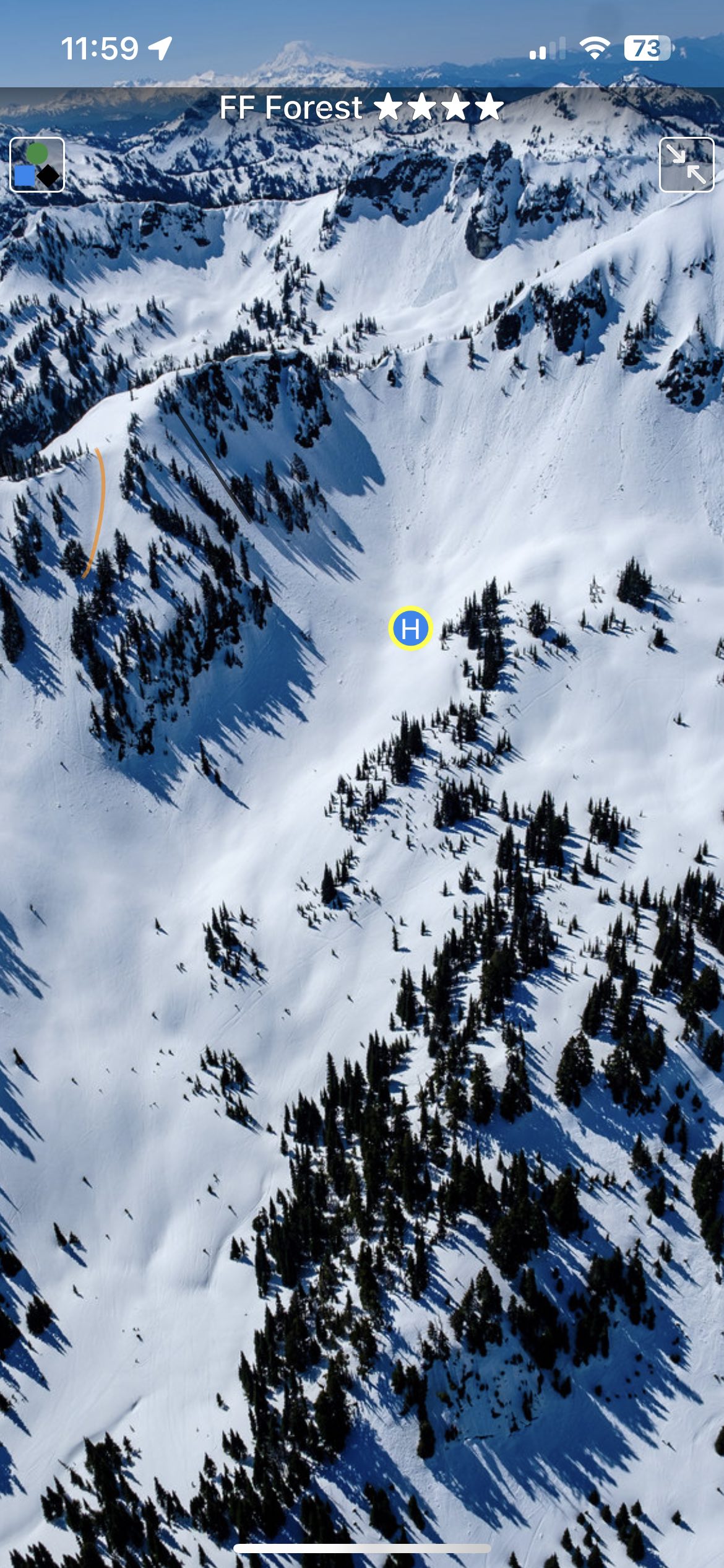
Backcountry Skiing: Crystal Mountain, Washington
by Matt Schonwald
Northwest Avalanche Center
Beacon Guidebooks:
California: Tahoe Light Tours Colorado: Berthoud | Buffalo | Cameron | Crested Butte | Loveland | Marble | RMNP | Silverton New Mexico: Taos Oregon: Hood Washington: Baker | ONP | Snoqualmie | Stevens
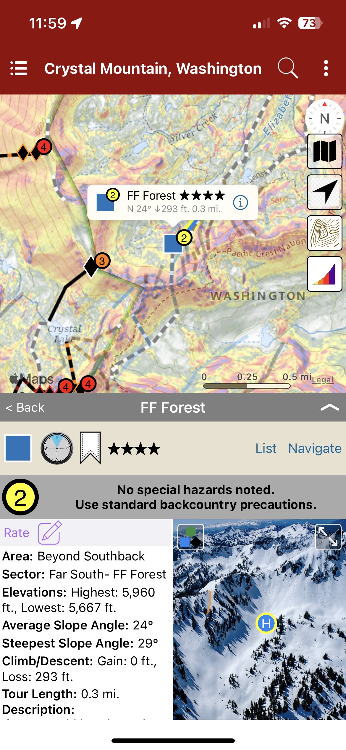
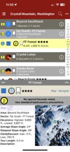
Author Matt Schonwald has drawn from his experience to bring this Crystal Mountain backcountry guidebook to you. This guidebook features aerial photos, an offline GPS, max slope angles, run descriptions and a terrain rating system maximizing terrain options and relevant information. Schonwald assesses each zone to provide information that is essential for your tour planning and decision making. Covering everything from mellow glades to steep couloirs, you’re sure to find the right tour for your group.
Buy digital plus book and the price includes $4.00 for shipping, a screaming deal! When you buy a bundle, you can use your digital rakkup guidebook immediately.
-

-
Map view
-
-
List view
-
-
Topo photo
by todd | Jan 8, 2018
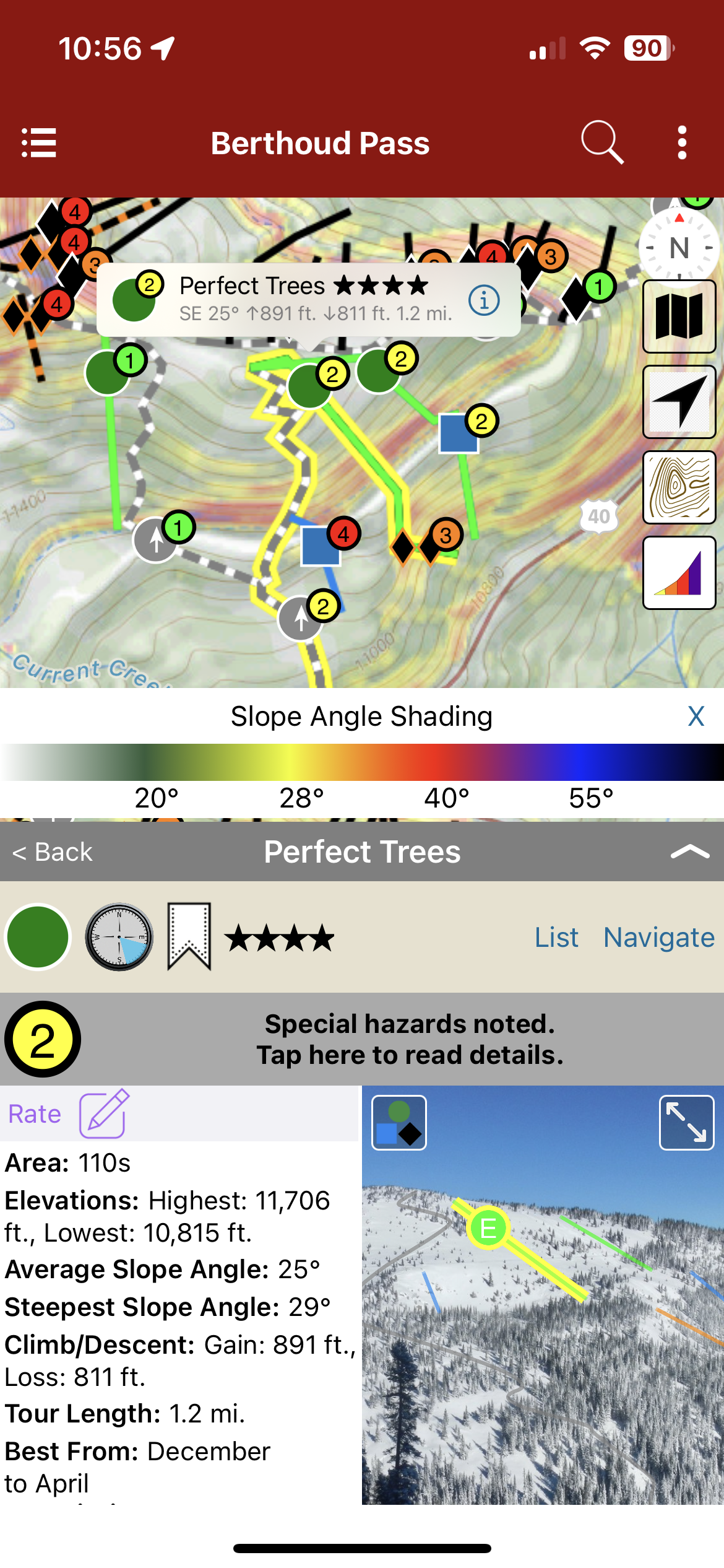
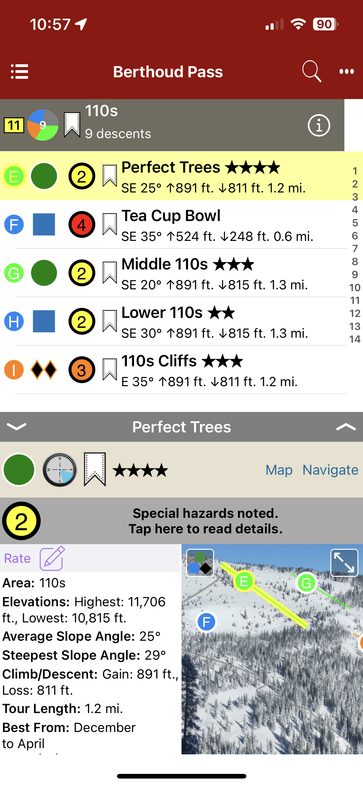
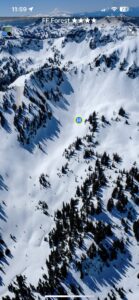
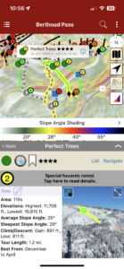
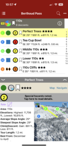
Backcountry Skiing: Berthoud Pass, Colorado
by Rob Writz
Colorado Avalanche Information Center
Beacon Guidebooks:
California: Tahoe Light Tours Colorado: Buffalo | Cameron | CO Light Tours | Crested Butte | Loveland | Marble | RMNP | Silverton New Mexico: Taos Oregon: Hood Washington: Baker | Crystal | ONP | Snoqualmie | Stevens
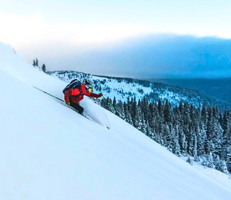
Welcome to the epicenter of backcountry skiing and snowboarding on Colorado’s Front Range. Since the 1930s skiers have been exploring the slopes surrounding US Highway 40 as it climbs and descends Berthoud Pass. This was the former home of one of Colorado’s pioneering ski areas and when it closed, the Pass quickly emerged as the most popular backcountry ski destination on the Front Range. Quick access, a consistent snowpack, and endless discovery continue to draw skiers to Berthoud Pass. The east to west orientation of the Pass, located high above the Fraser River and Clear Creek valleys, attracts a deep snowpack benefiting from both northwest flow and upslope storms. In just over an hour drive from Denver, backcountry skiers have access to numerous trailheads leading into the high basins surrounding the Pass. From pre-work dawn patrols, to car shuttling, to all day epics, Berthoud Pass has an adventure for backcountry riders of all skill levels. The glade skiing, deep powder bowls, and steep couloirs of Berthoud Pass have enough terrain to keep you busy for a lifetime.
Buy digital plus (book and/or map) and the price includes $4.00 for shipping, a screaming deal! When you buy a bundle, you can use your digital rakkup guidebook immediately.
-
-
Map view
-
-
List view
-
-
Full screen photo topos
by todd | Jan 1, 2017
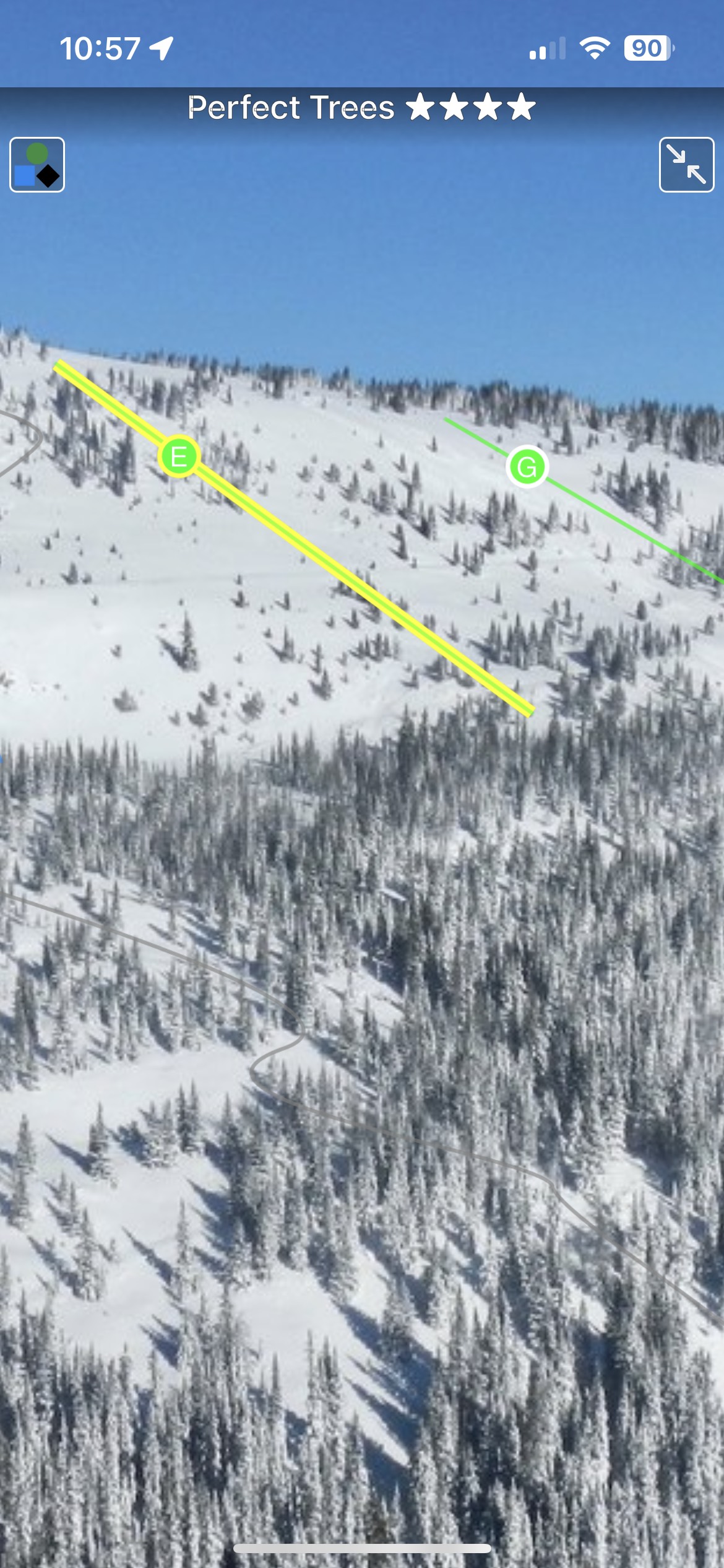
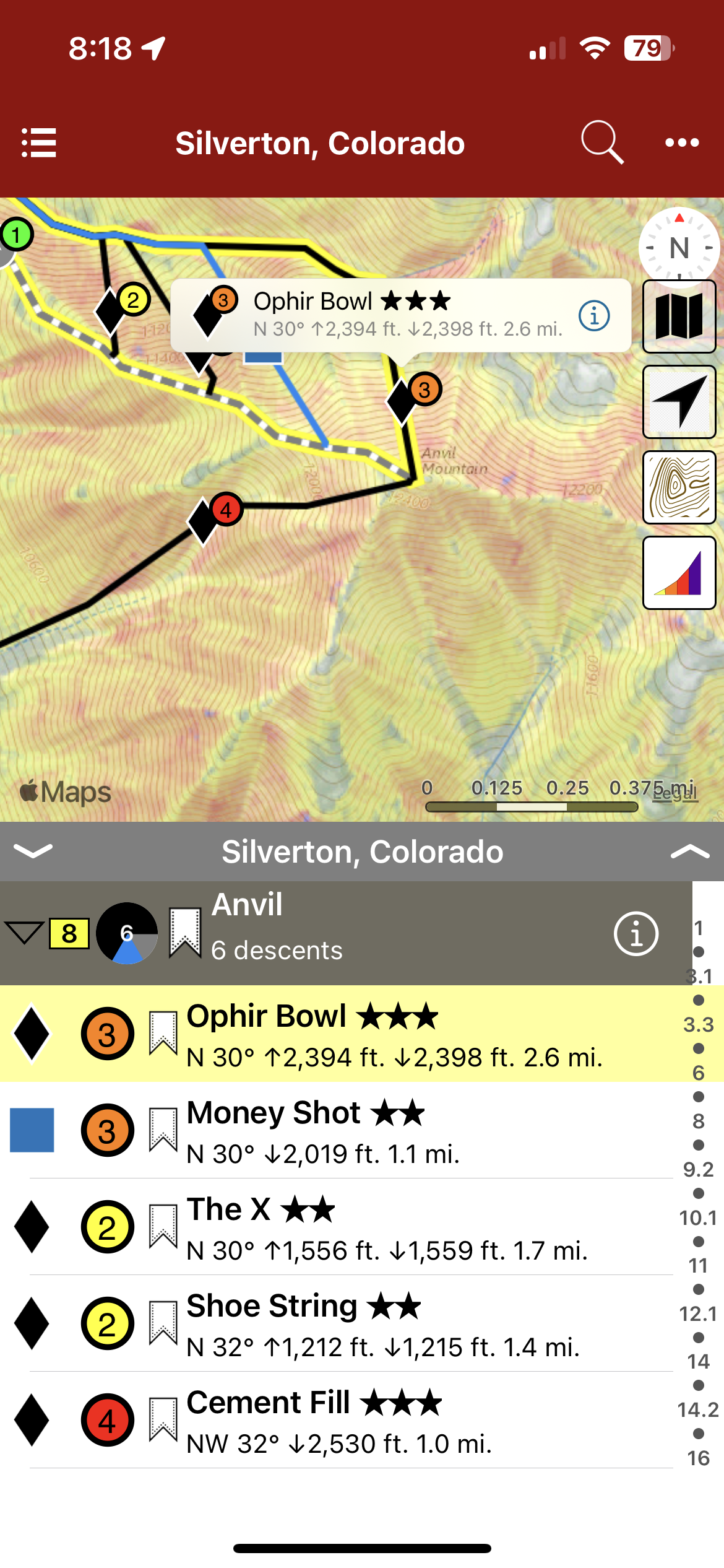
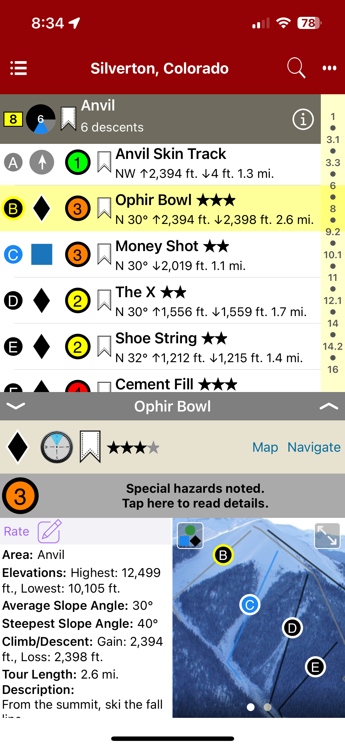
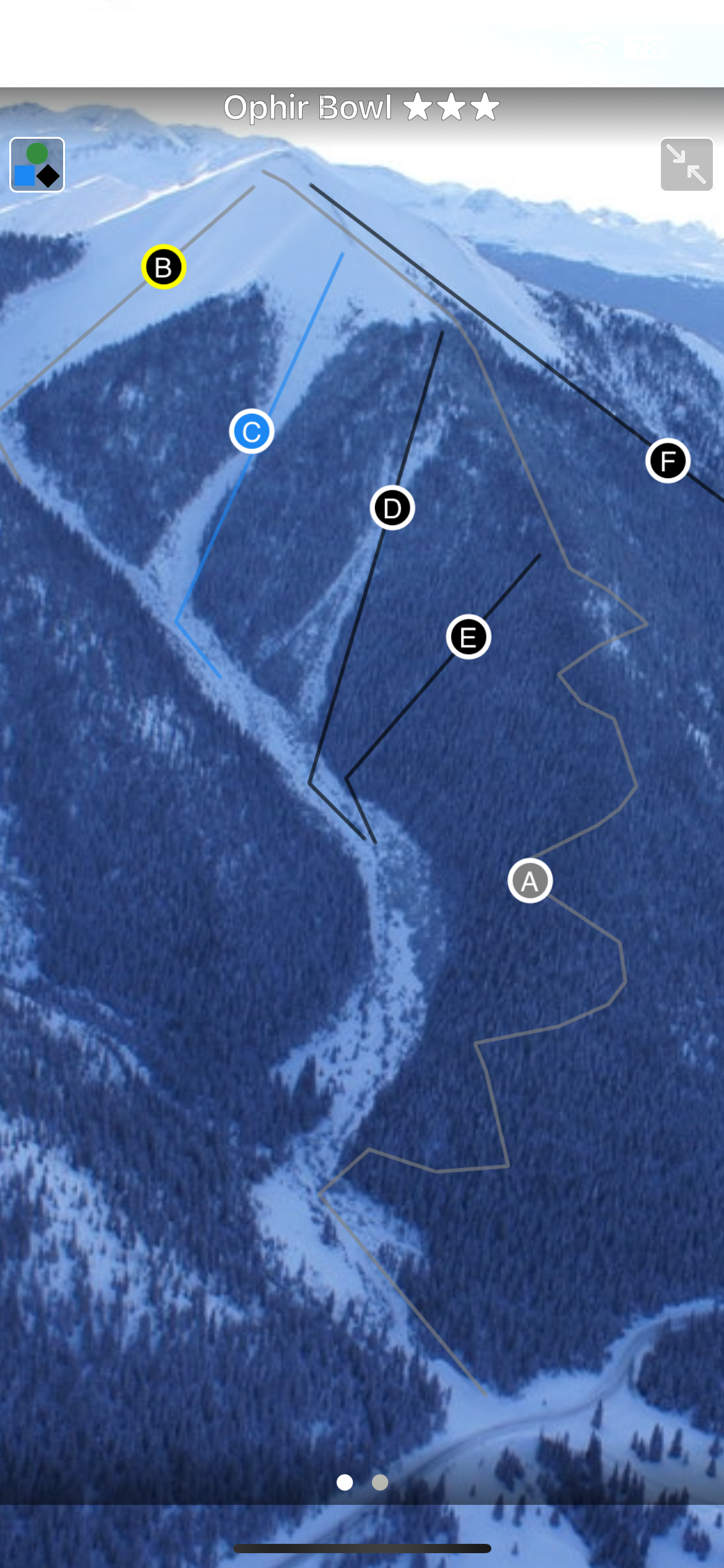
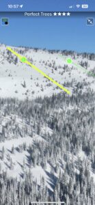
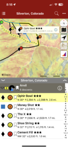
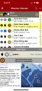
Backcountry Skiing: Silverton, Colorado
by Josh Kling
Crested Butte Avalanche Center
Beacon Guidebooks:
California: Tahoe Light Tours Colorado: Berthoud | Buffalo | Cameron | CO Light Tours | Crested Butte | Loveland | Marble | RMNP New Mexico: Taos Oregon: Hood Washington: Baker | Crystal | ONP | Snoqualmie | Stevens
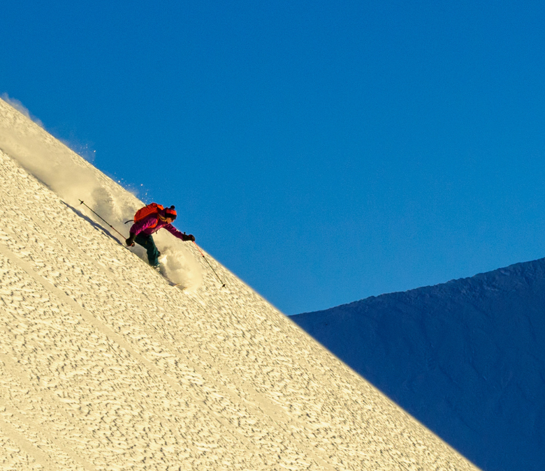
Home to multiple ski areas, extreme skiers and sledders, ski and mountain guides, and an incredibly rich mining history, the sleepy town of Silverton is a fantastic place to visit. It speaks for itself when it comes to remote and rugged mountain towns of the west. Many mountain ranges do not have a year round maintained road passing through them. The San Juan Mountain Range, from Durango through Silverton and on to Ouray has three: Coal Bank, Molas, and Red Mountain Passes. Highway 550 brings powder-hounds through some of Colorado’s most remote and diverse ski terrain. Basins adjacent to Highway 550, also known as the Million Dollar Highway, boast an annual snowfall of 400”. The mountains accessed from Silverton possess some of the largest ski descents in the lower 48, and some of the deepest snow in all of Colorado. The locations showcased in this atlas offer the entire spectrum of terrain and difficulty, from novice to extreme and everything in between. Provided you already have a small amount of experience as a backcountry skier and have completed a Level 1 avalanche course, there is something in this atlas for everyone.
.
Buy digital plus (book and/or map ) and the price includes $4.00 for shipping, a screaming deal! When you buy a bundle, you can use your digital rakkup guidebook immediately.
-
-
Map view
-
-
List view
-

-
Full screen photos
by todd | Oct 30, 2016
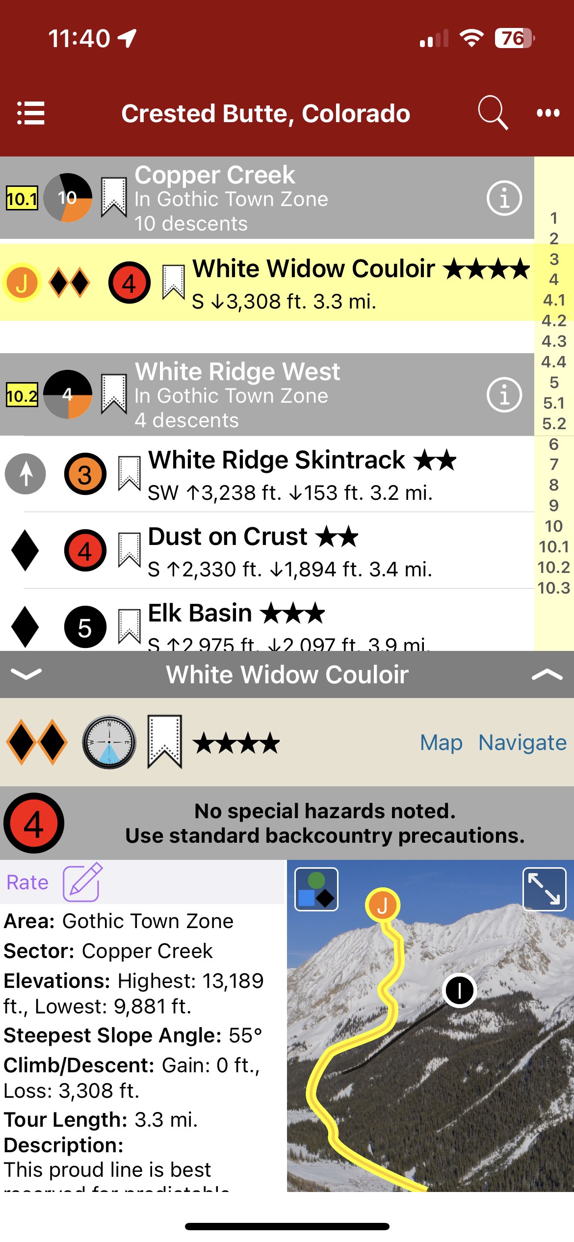
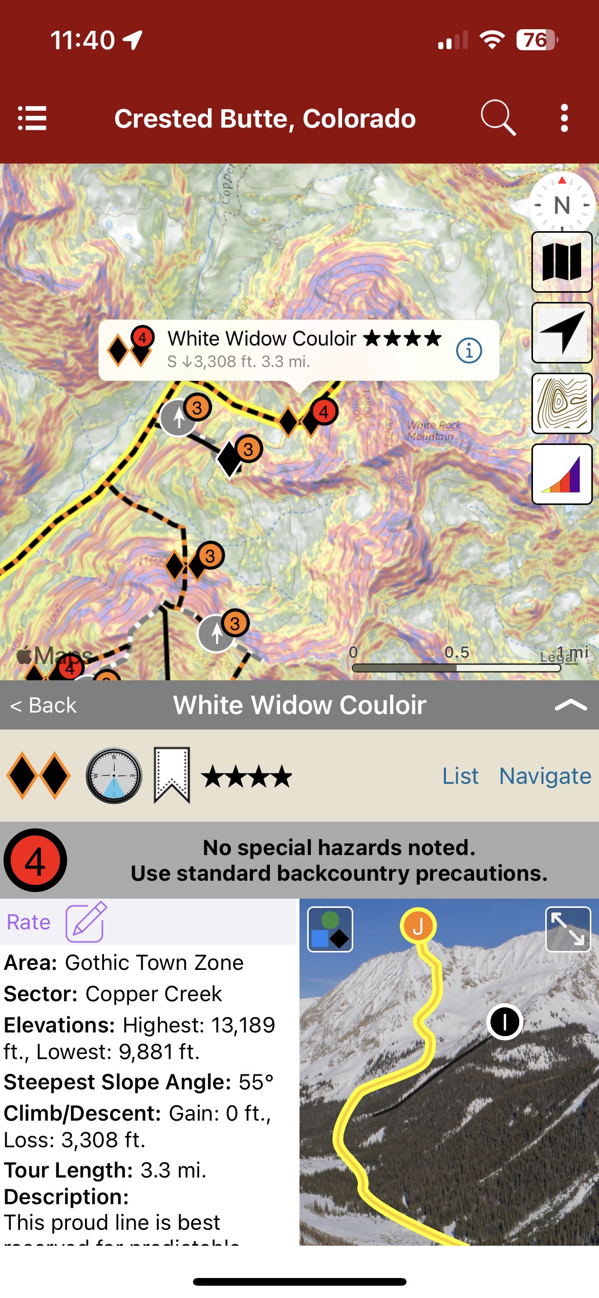
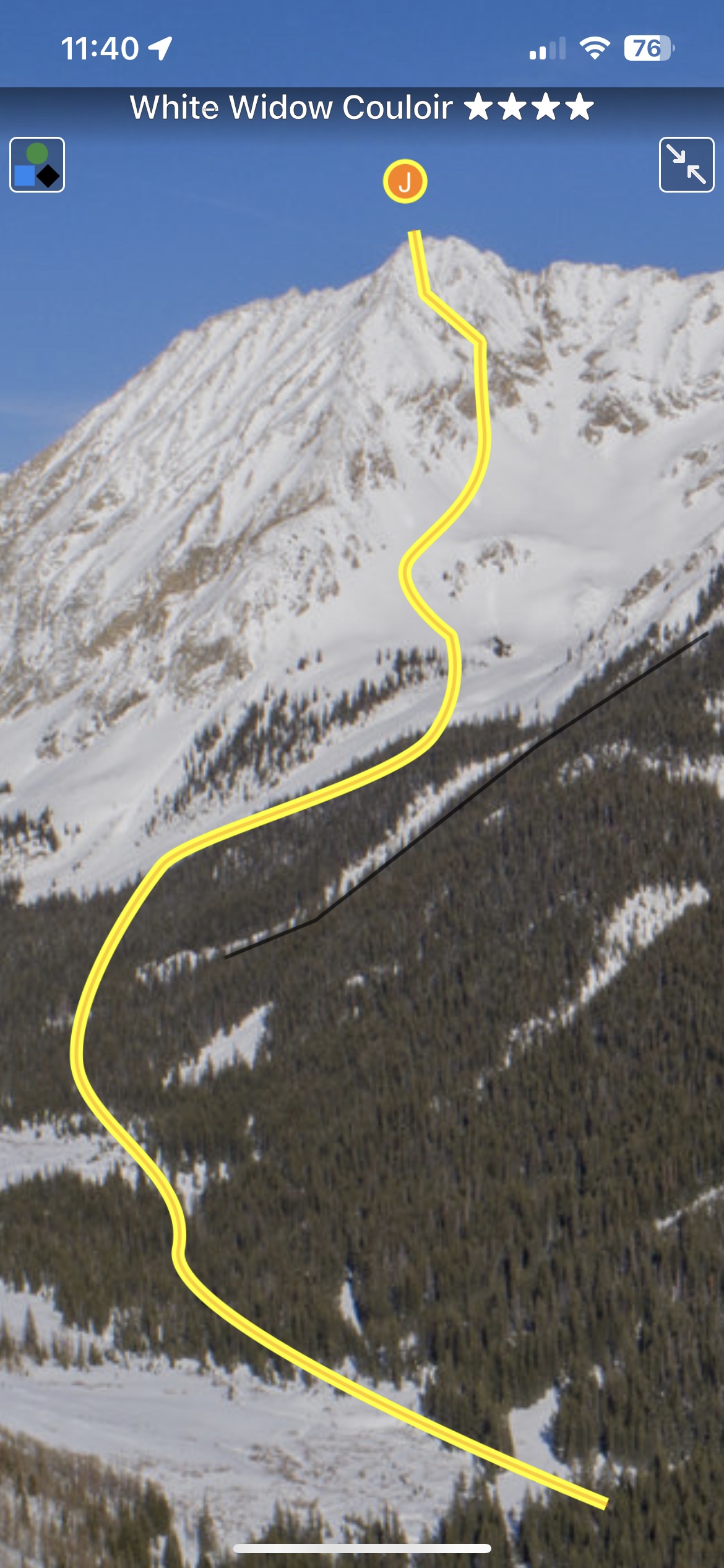
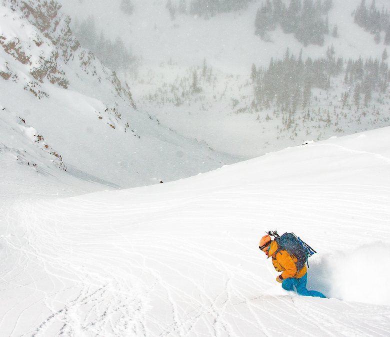
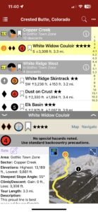
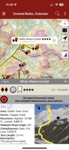
Backcountry Skiing: Crested Butte, Colorado
by Andy Sovick
Crested Butte Avalanche Center
Beacon Guidebooks:
California: Tahoe Light Tours Colorado: Berthoud | Buffalo | Cameron | CO Light Tours | Loveland | Marble | RMNP | Silverton New Mexico: Taos Oregon: Hood Washington: Baker | Crystal | ONP | Snoqualmie | Stevens
Whether you’re skiing The Pencil or taking a quick lap on the front side of Snodgrass, this Crested Butte rakkup guidebook uncovers a wealth of information about the terrain. The updated and augmented digital atlas shows new zones including Copper Creek and Upper East River. This is the terrain primarily accessed from the famous Gothic Ski Huts. It shows ascent routes, descent descriptions, max slope angles, a trail map, offline GPS navigation and much more. Use this tool for terrain management, route finding, tour planning, and to guide your decision making process.
Buy digital plus book or map and the price includes $4.00 for shipping, a screaming deal! When you buy a bundle, you can use your digital rakkup guidebook immediately.
-
-
List view
-
-
Map view
-

-
Topo photo