by todd | Apr 24, 2015
Foster Falls
by Micah Gentry and Cody Averbeck
of Rockery Press
Southeastern Climbers Coalition
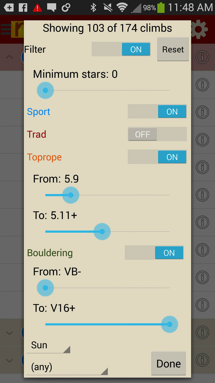
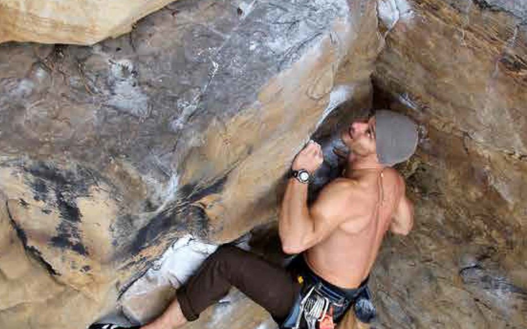
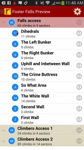
Foster Falls is named for the unmistakable 80 foot waterfall that drops dramatically into the Little Gizzard Creek, a smaller stream that is part of a larger network of coves and creeks that make up the impressive Fiery Gizzard drainage. The developed cliff at Foster Falls is owned and managed by the South Cumberland State Park which manages several near-by natural attractions that are frequented by hikers and outdoor enthusiasts of all ages. For the Rock Climber, however, Foster Falls rock climbing is the crown jewel of the South Cumberland State Park – offering almost 200 high quality sport climbs on superb Southern Sandstone. The long cliff sits in a southeasterly orientation and serves as a year-round climbing destination. In warm weather months, walls in the interior of the drainage (closer to the falls) remain shaded by towering hemlocks and broad-leafed magnolias that offer a break from the summer sun. In colder months, the south facing walls further out from the falls offer tall and exposed routes that make for great winter outings. The cliff averages sixty feet in height – with many routes that are taller, and shorter. The climbing ranges from jug laden slab climbs to quadruple stacked tiered bunkers. Because of this, Foster Falls possesses the greatest variety of sport climbing found in the Chattanooga area with new routes popping up all of the time. For this reason, it is among the most popular cliffs in the region. This initial release contains 174 climbs and will be updated when new routes go up.
-
-
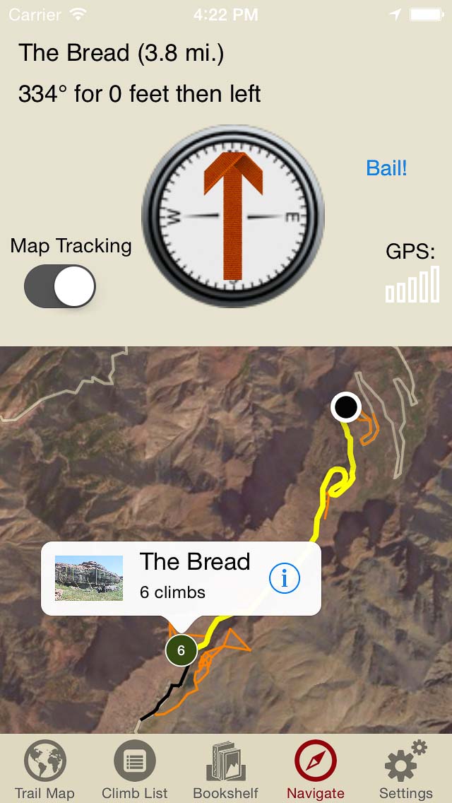
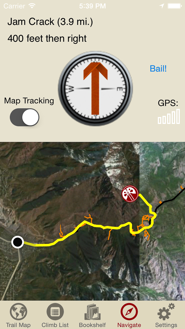
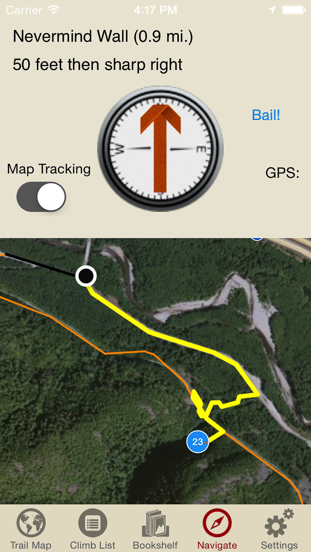
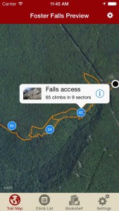
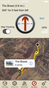
Explore Foster Falls climbing via our interactive trail map.
-
-
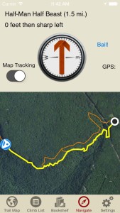
rakkup guides you turn by turn to your climb then shows you a picture when you arrive. Awesome.
-
-
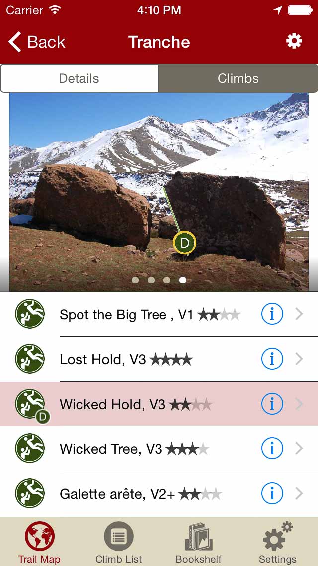
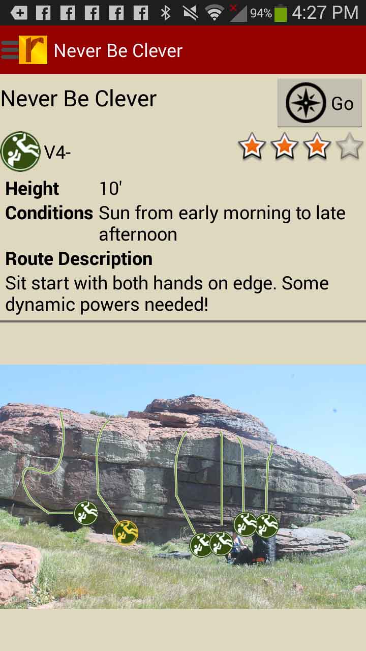
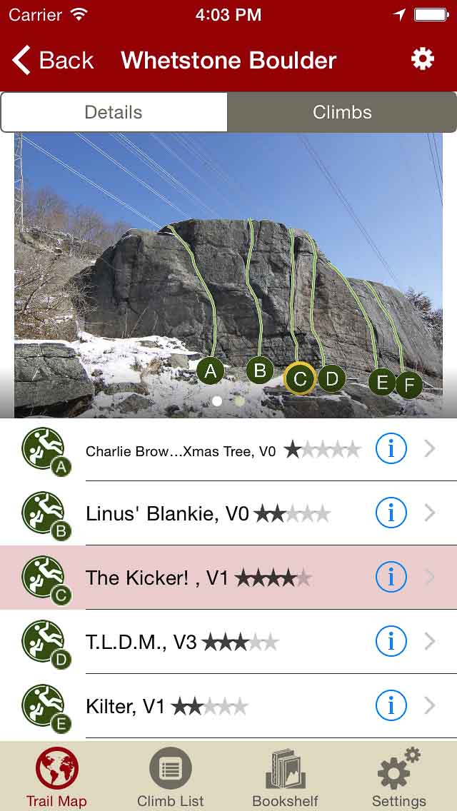
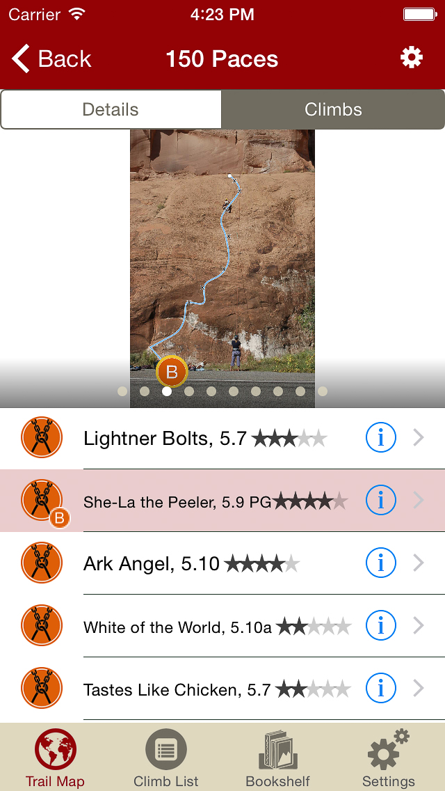
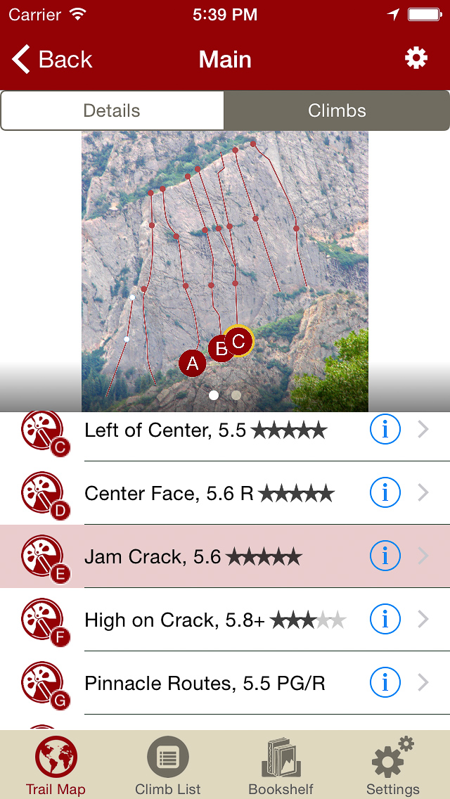
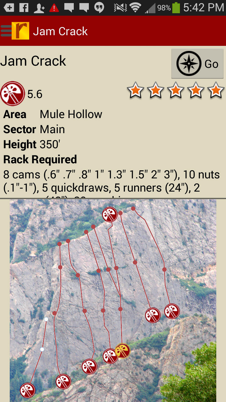
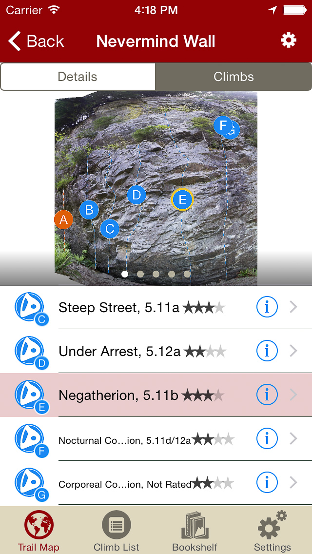
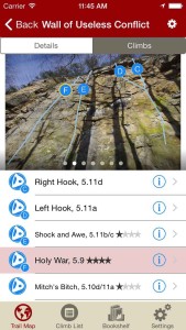
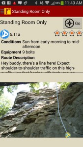
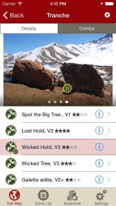
Tap on a climb name, see where it’s located on the image. Tap on a climb bubble in the image, discover what climb it is. So nice…
-
-
All the Foster Falls climbs at your fingertips.
-

-
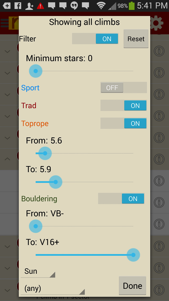
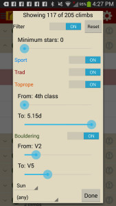
Sort all those climbs to only the grades you want to see. Too hot? No prob, filter by in shade only.
-
-
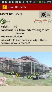
Tired of bad beta? Use local experts, Micah & Cody’s beta to send your next proj!
by todd | Apr 12, 2015
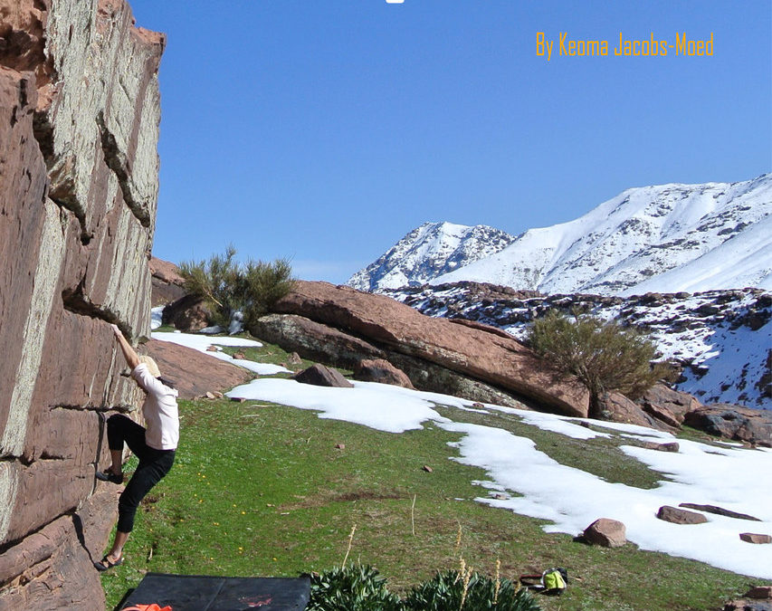
Oukaimeden Bouldering Morocco
by Keoma Jacobs from Imiksimik
Imiksimik Facebook
Oukaimeden Morocco Bouldering has the potential to be the next Rocklands. It is the first bouldering destination in the High Atlas Mountains of Morocco. In summary, the guidebook includes almost 800 problems of which a handful in the 8th grade, more than 100 problems in the 7th grade, 362 problems ranging between 3+ to 5+ and almost 300 in 6th grade.
Special thanks to Nico Pelorson & Tanguy Topin and the efforts of the entire Groupe Excellence Escalade FFCAM for making so many First Ascents. Not all FA are yet in this edition since more in formation is needed. Approximately 100 new problems in this guidebook are the result of the climbers efforts during the imiksimiktrip in 2018.
But I can assure you, the potential in Oukaimeden is mind boggling, and there will be many more problems in future guidebook updates.
-
-
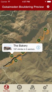
Explore Oukaimeden bouldering via our interactive trail map.
-
-
rakkup guides you turn by turn to your boulder then shows you a picture when you arrive.
-
-
Tap on a problem name, see where it’s located on the image. Tap on a problem ID badge in the image, discover what problem it is.
-

-
Oukaimeden problems in a searchable list.
-
-
Sort all those problems to only the grades you want to see.
-
-
Helpful beta.
by todd | Apr 7, 2015
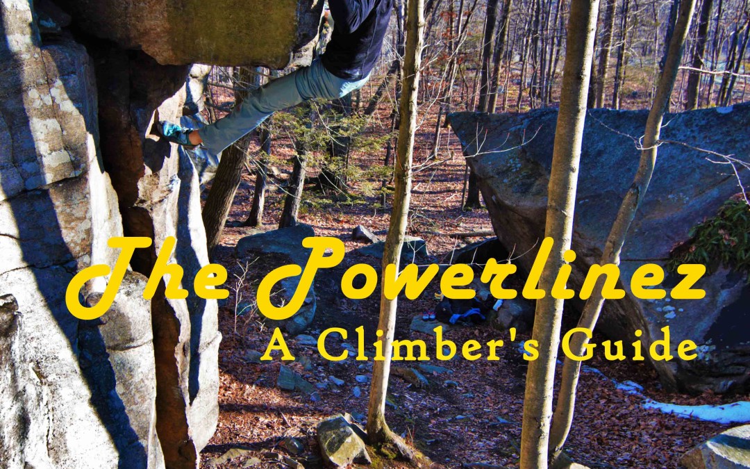
The Powerlinez: A Climber’s Guide
by Norm Rasmussen & Matt Ratajczak
Powerlinez Facebook Group
Powerlinez Facebook Beta Shed
Powerlinez rock climbing opened for climbing in May of 2013 thanks to the efforts of the Torne Valley Climbers’ Coalition. The Powerlinez is located on the SE side of Torne Mountain in the Southern portion of Harriman State Park in New York. This guidebook is the second guide to come out for the area and accounts for the explosion of development that happened soon after the area opened for climbing.
Even though it is located in a state park, there is no fee associated with climbing at the Powerlinez. You do need to fill out a waiver, however. Please be sure you fill out a yearly waiver that is available at The Gravity Vault Indoor Rock Gyms (Upper Saddle River or Chatham) or Rock and Snow .
Since the area is still under development, be sure to always check for updates here on rakkup. Be sure to join the Facebook group Powerlinez – Beta Shed for development discussion and to find partners. If there is no route where you think there should be one – try and develop it! Just note all new climbs must go through the above mentioned Facebook Group or email me at Norman dot Rasmussen at me.com
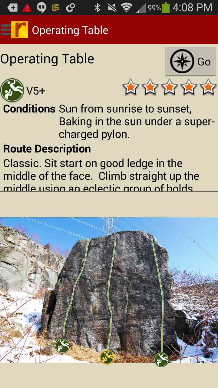
The rock at the Powerlinez is characterized as sharp and gritty gneiss. Many of the holds can be sharp as razors, so be sure to tape up for any crack climbs. The top outs are notoriously heart-pounding and heady. Always packed with slopers that just don’t feel confident, topping out is a head game to overcome at the Powerlinez. Omicron Crack (V3) or Shots Fired (5.12) are classic examples.
Much of the area’s less popular walls are either short rope walls or high-ball boulder problems. Pick your poison.
In the mean time, get your waiver signed, be safe and have fun! Let’s take advantage of this awesome area close to home and preserve the area as it’s meant to be!
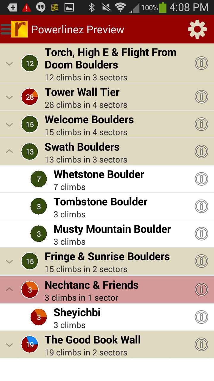
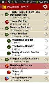
We keep adding climbs and there are still so many to go! We have packed more than enough for you to wet your chapped lips at the Powerlinez! Currently there are 140 climbing routes (5 Sport, 91 Trad and 44 Top Rope) along with 229 Boulder problems. And we’ve only scratched the surface!
The number of stellar walls have been too many to list here, but some highlights include:
– The obvious and very popular Tower Wall
– The sporty Good Book Wall
– The multi-route behemoth, The Immelman
– Bouldering training ground, Rock Dojo
– And so much more… new climbs are being developed and added constantly.
Stay tuned – we hope this Spring is full of newly developed climbs and all new sends! Get after it!
-
-
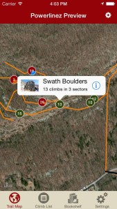
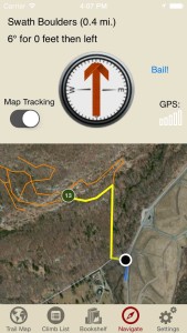
Explore Powerlinez climbing & bouldering like it was meant to be explored via our interactive trail map.
-
-
rakkup guides you turn by turn to your climb then shows you a picture when you arrive. Awesome.
-
-
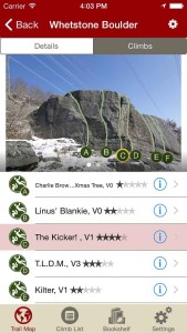
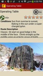
Tap on a climb name, see where it’s located on the image. Tap on a climb bubble in the image, discover what climb it is. So nice…
-
-
All the Powerlinez climbs & problems at your fingertips.
-
-
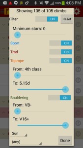
Too much to handle? Sort all those climbs to only the grades you want to see. Too hot? No prob, filter by in shade only.
-
-
Tired of bad beta? Use local experts, Norm & Matt’s beta to send your next proj!
by todd | Mar 16, 2015
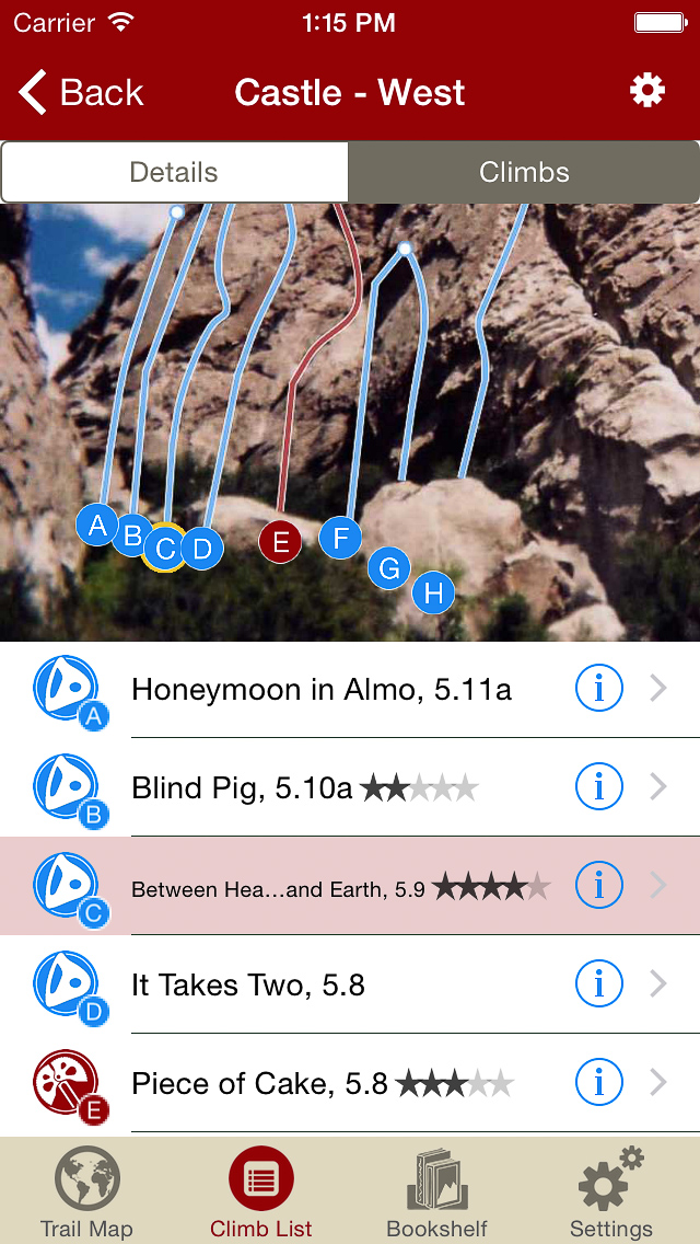
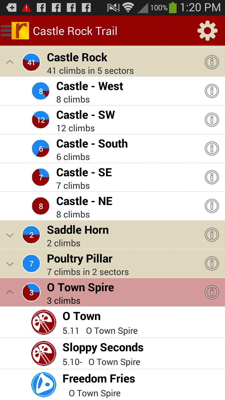
Castle Rocks Rock Climbing
by Tony Calderone
A hike through Castle Rocks State Park leaves the visitor wondering if this place was made for climbers. A high altitude desert. Not mountainous, but with rocks everywhere. Some rising over 500 feet. The current version of this guidebook includes:
– 112 sport routes
– 227 traditional routes
– 7 toprope routes
– 10 boulder problems
New routes and photographs are constantly added to improve functionality. GPS navigation, bolt locations and route lengths set this Castle Rocks climbing guidebook apart from any other. And it is all in your pocket. With 356 routes, this is the largest collection of routes ever published to Castle Rocks. And it is all in your pocket.
-
-
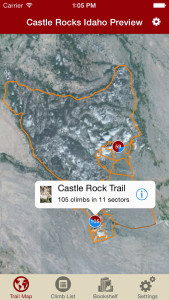
Explore Castle Rocks climbing like it was meant to be explored via our interactive trail map.
-
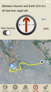
-
rakkup guides you turn by turn to your climb then shows you a picture when you arrive. Awesome.
-

-
Tap on a climb name, see where it’s located on the image. Tap on a climb bubble in the image, discover what climb it is. So nice…
-
-
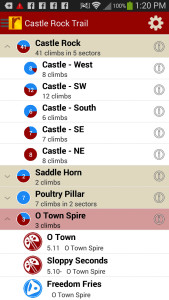
All Castle Rocks climbs at your fingertips.
-

-
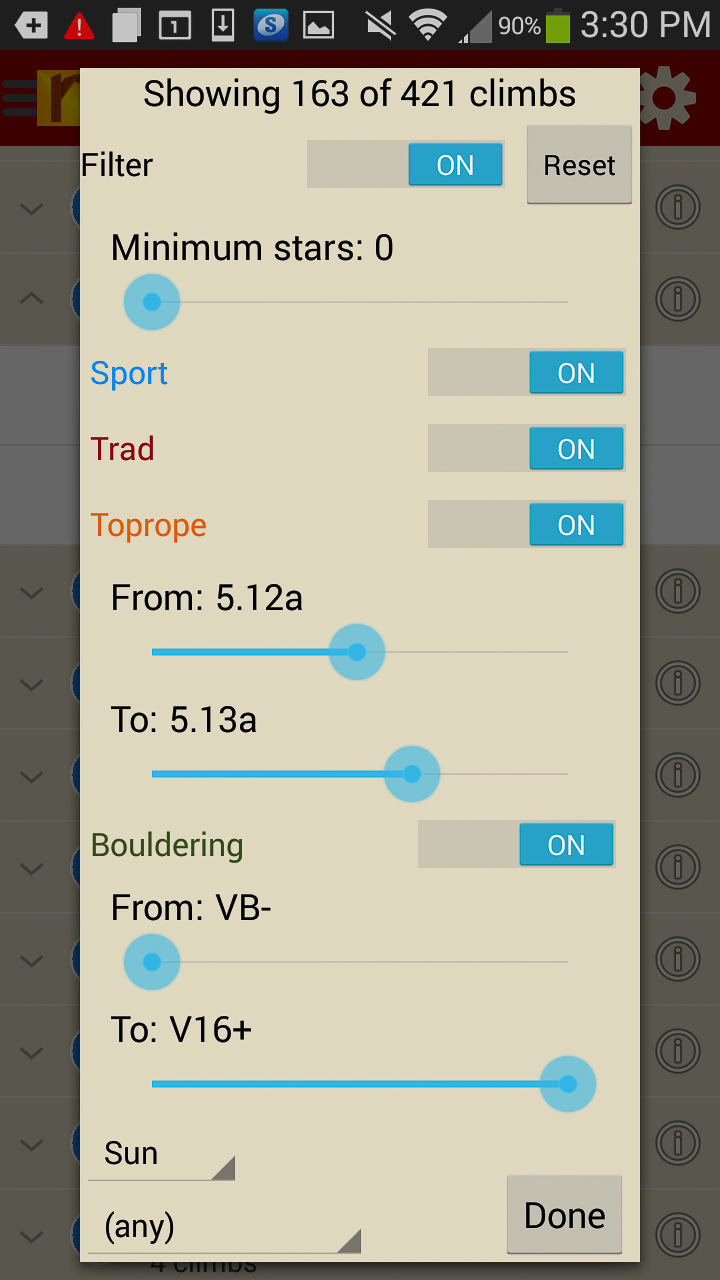
Too much to handle? Sort all those climbs to only the grades you want to see. Too hot? No prob, filter by in shade only.
-
-
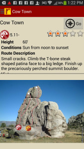
Tired of bad beta? Use local expert, Tony’s beta to send your next proj!
by todd | Mar 3, 2015
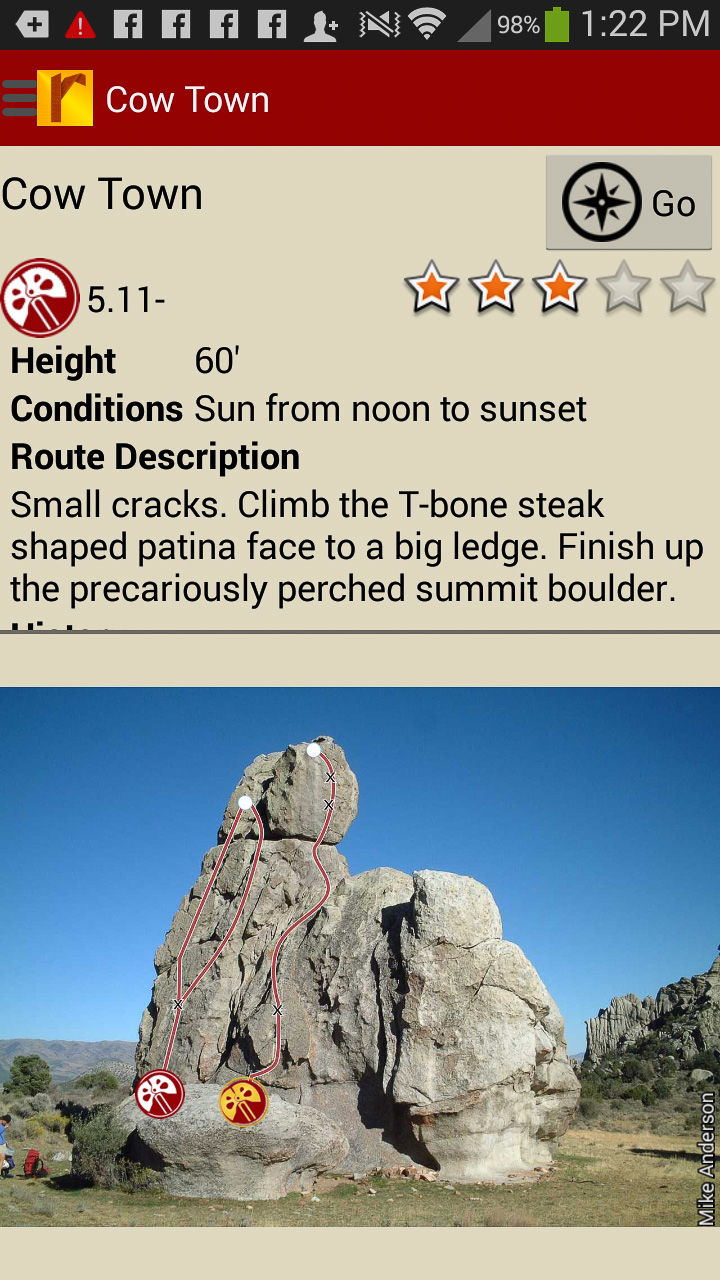
Moab Rock Climbing
by Tony Calderone
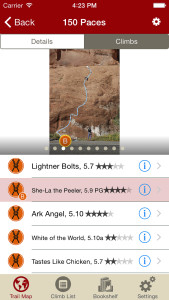
Moab Rock Climbing contains 200 rock climbs within 30 miles of Moab, Utah. Significant updates are pending in the next year that will explode this guide to 1,000 routes. Learn a little about the Moab climbing scene from Tony’s perspective here.
-
-
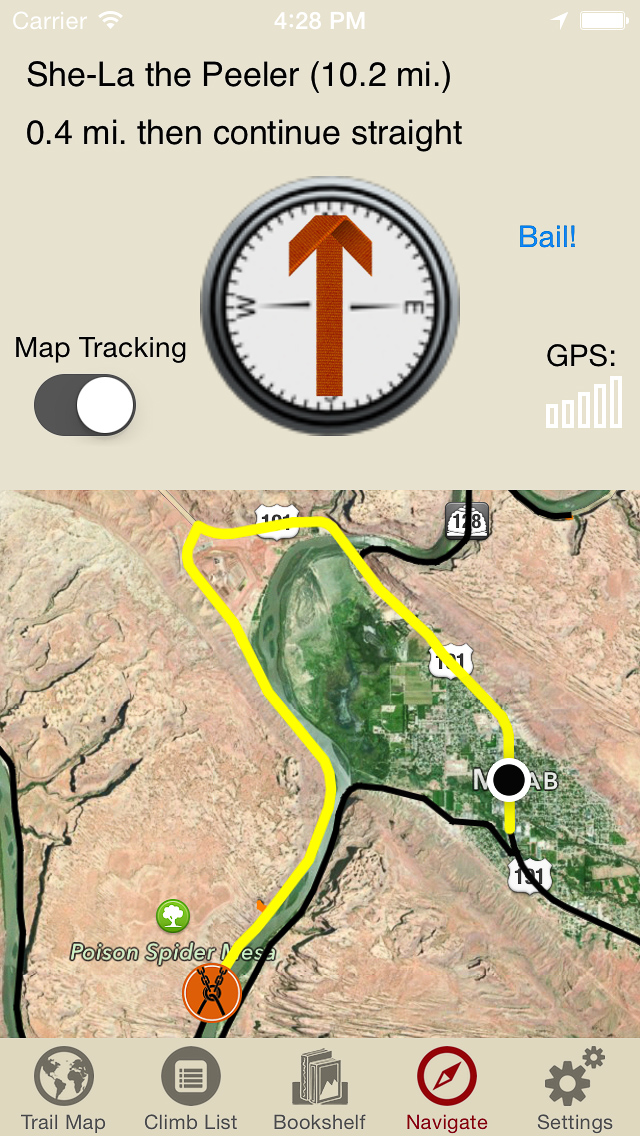
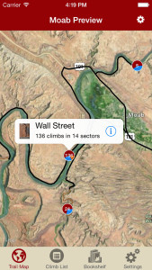
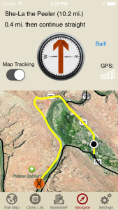
Explore Moab rock climbing like it was meant to be explored via our interactive trail map.
-
-
rakkup guides you car to crag then shows you a picture when you arrive. Awesome.
-
-
Tap on a climb name, see where it’s located on the image. Tap on a climb bubble in the image, discover what climb it is. So nice…
-

-
All Moab climbs at your fingertips.
-
-
Too much to handle? Sort all those climbs to only the grades you want to see. Too hot? No prob, filter by in shade only.
-
-
Tired of bad beta? Use local guide Tony’s beta to send your next proj!
by todd | Feb 16, 2015
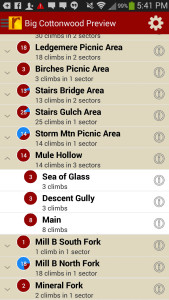
Big Cottonwood Rock Climbing
by Tony Calderone
Little Cottonwood Climbing | Wasatch Front Bouldering | Ferguson Canyon | Wasatch Wilderness Climbing | Wasatch Bench Climbing
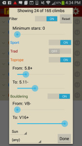
Big holds and big air. Everything that matters to climbers is bigger in Utah’s Big Cottonwood Canyon. 754 routes in every major crag are included. Look forward to seeing the biggest collection of Big Cottonwood topos ever compiled. 25 years of research has gone into this guide.
-
-
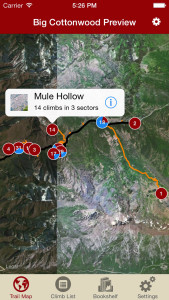
Explore Big Cottonwood like it was meant to be explored via our interactive trail map.
-

-
rakkup guides you car to crag then shows you a picture when you arrive. Awesome.
-

-
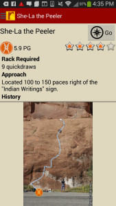
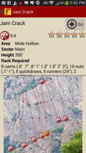
Tap on a climb name, see where it’s located on the image. Tap on a climb bubble in the image, discover what climb it is. So nice…
-
-
Big Cottonwood route list at your fingertips.
-
-
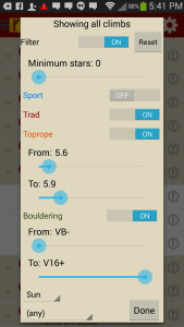
Too much to handle? Sort all those climbs to only the grades you want to see. Too hot? No prob, filter by in shade only.
-
-
Tired of bad beta? Use local guide, Tony’s beta to send your next proj!
by todd | Feb 5, 2015
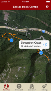
Exit 38 Rock Climbing
by Todd Kutzke and Rob Price
Outdoor Geeks, LLC
The crags of North Bend, WA offer a beautiful getaway for Seattle-area climbers with convenient climbing from Spring through Fall. This detailed digital guidebook features accurate beta, car to crag navigation and detailed smart topo photos for all the best climbs at the south side Deception and Mt. Washington crags, as well as, the north side Far Side crags.
-
-
Explore Exit 38 rock climbing via our interactive trail map.
-

-
rakkup guides you car to crag then shows you a picture when you arrive.
-

-
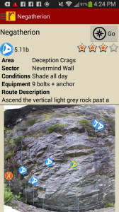
Tap on a climb name, see where it’s located on the image. Tap on a climb bubble in the image, discover what climb it is.
-
-
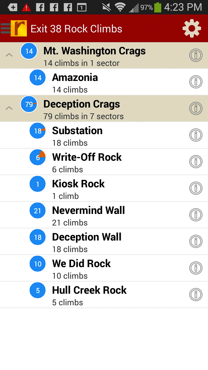
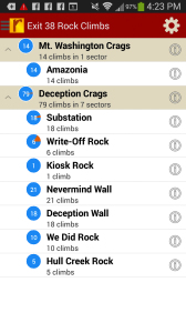
Exit 38 rock climbs in a searchable list.
-
-
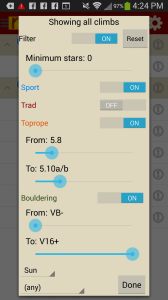
Filter the route list to only the grades and quality you want to see.
-
-
Detailed route descriptions and pictures with topo lines for every route.
by todd | Feb 1, 2015
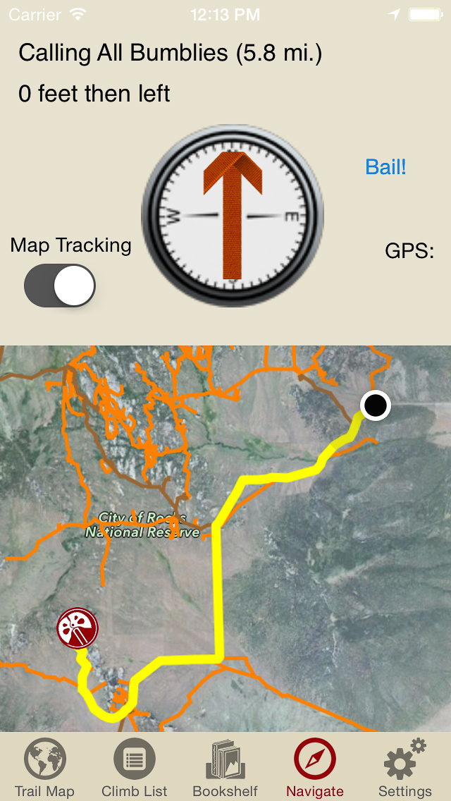
City of Rocks Rock Climbing
by Tony Calderone
Climbers from around the world have been praising the quality of climbing at Idaho’s City of Rocks for years. The City has been heralded as one of North America’s premier climbing venues. This geographically isolated region has also been shrouded in intrigue, mystery and controversy. Tony leaves no stone unturned in his comprehensive approach to describing the City of Rocks climbing. The scope, depth and accuracy of his rakkup digital guidebook is truly amazing. This is the most comprehensive City guidebook to ever be produced including:
– 671 traditional routes
– 205 sport routes
– 65 top-rope routes
– 7 boulder problems and growing
An awesome variety of highly featured faces, smooth slabs and intermittent cracks on superb quality granite offers something for everyone, whether beginner or expert. The unique high desert environment, bizarre-shaped rock formations, convenient camping, rich cultural history and fabulous climbing attracts visitors from around the globe. Tony’s City of Rocks rakkup guidebook is an unparalleled source of climbing information on this magnificent American treasure.
-
-
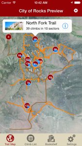
Explore City of Rocks like it was meant to be explored via our interactive trail map.
-

-
rakkup guides you car to crag then shows you a picture when you arrive. Awesome.
-
-
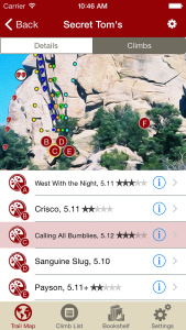
Tap on a climb name, see where it’s located on the image. Tap on a climb bubble in the image, discover what climb it is. So nice…
-
-
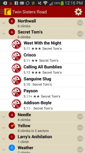
City of Rocks climbs at your fingertips.
-
-
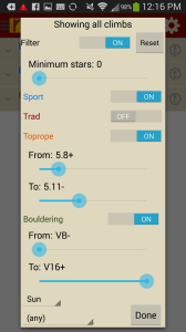
Too much to handle? Sort all those climbs to only the grades you want to see. Too hot? No prob, filter by in shade only.
-
-
Tired of bad beta? Use local guide, Tony’s beta to send your next proj!
by todd | Jan 20, 2015
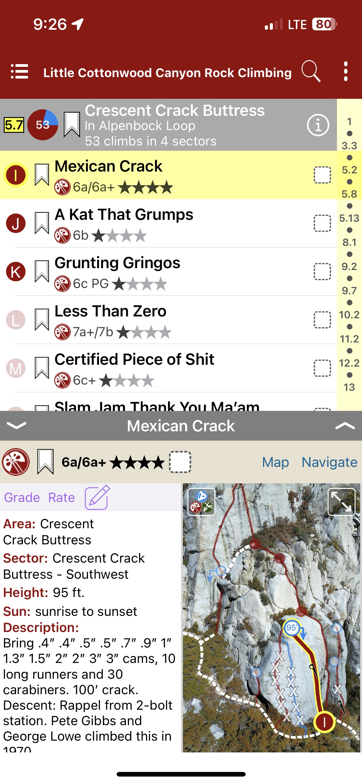
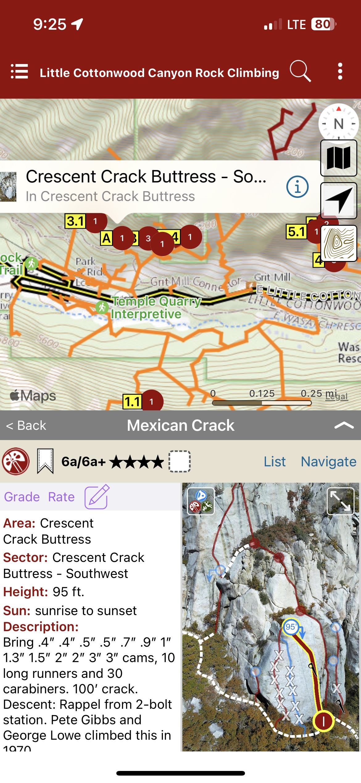
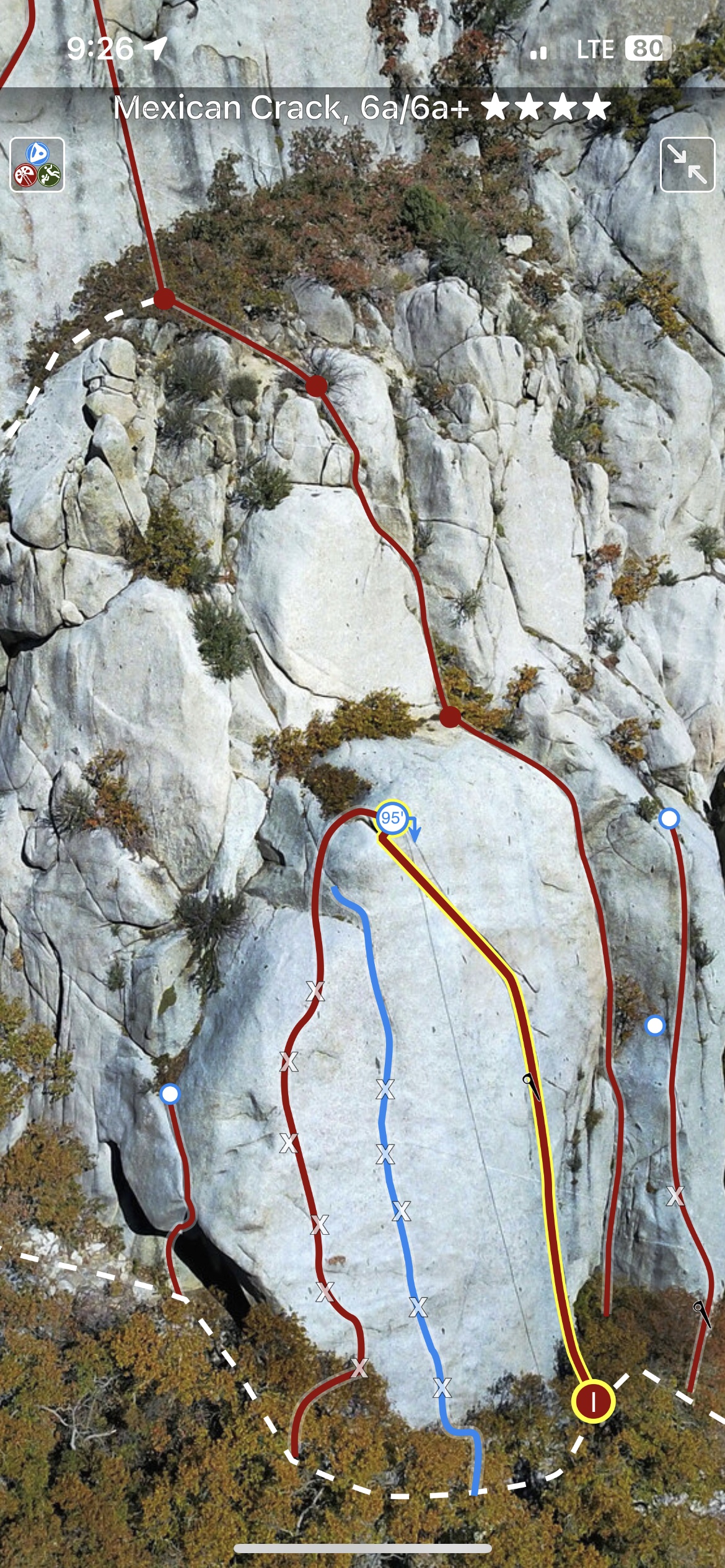
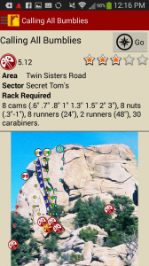
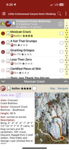
Little Cottonwood Rock Climbing
by Tony Calderone
Wasatch Front Bouldering | Big Cottonwood Climbing | Ferguson Canyon | Wasatch Wilderness Climbing | Wasatch Bench Climbing
Twenty minutes from downtown Salt Lake City lies the largest concentration of rock climbs in Utah. The true gem of Wasatch rock climbing. Little Cottonwood Canyon Rock Climbing!
Little Cottonwood Canyon is located within the Wasatch-Cache National Forest along the eastern border of the Salt Lake Valley, where the Rocky Mountains meet the Great Basin, roughly twenty miles southeast of Salt Lake City, Utah.
The canyon is a popular sightseeing destination and is a glacial trough carved by an alpine glacier during the last ice age, approximately 15,000 to 25,000 years ago. Albion Basin is famous for wildflowers and is one of the most photographed areas in northern Utah. Rare and endemic plant species are found in the area. Mountain goats inhabit the surrounding mountains.
Recreational activities in Little Cottonwood Canyon include hiking, camping, fishing, mountain biking, rock climbing, skiing, snowboarding, and backcountry use. There are two resorts in the canyon, Alta and Snowbird, providing both summer and winter recreational opportunities. The Utah Native Plant Society often conducts wildflower walks at Albion Basin and in other locations in the canyon. The paved portion of the road is approximately 8.3 miles from the base of the canyon to the top with an average grade of 9.2%, making it a popular road cycling challenge.
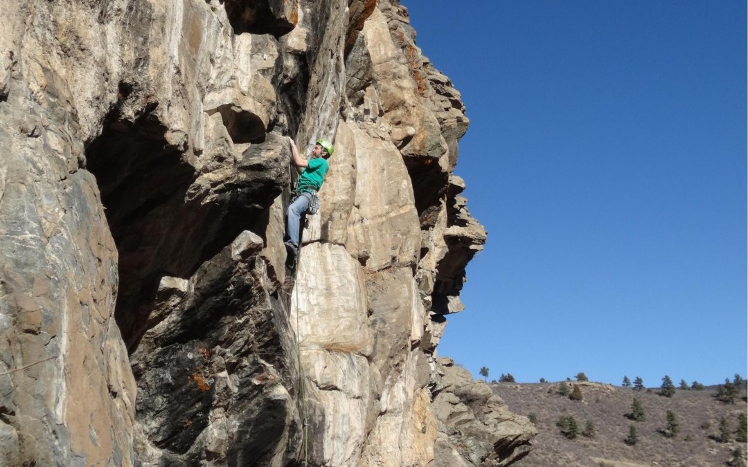
The lower third of the canyon is strewn with quartz monzonite outcroppings, mostly consisting of smooth steep faces. Local climbers informally refer to the rock as granite, which is a close relative.
Approaches involve parking along the road and hiking up through scrub oak, talus fields and large boulders.
Face climbing is the predominant technique, typically using a mixture of pre-placed bolts and cracks for protection, but there are many notable pure crack climbs as well. Most routes are 200-600 feet long, but routes of over 2,000 feet in length exist.
There is a long history of local community groups climbing in the canyon. Some notable groups through the years include: The Wasatch Mountain Club, The Alpenbock Club, The Steinfell Climbing Club and University of Utah climbing classes
The historical representation communicated herein endeavors to be an accurate picture of what happened in the past without sentimentality. This style of presentation necessarily risks hurting the feelings of those in the present. It also focus on facts and steer firmly away from assumptions, conjecture or opinion… which is always biased. You may find this approach to be of a decidedly old-fashioned style that lacks the snarkiness more common in modern works.
Consider, as you climb, that the rock was not nearly so clean of vegetation, flakes, dirt or massive loose blocks. Many of the earliest ascents were done without the aid of topropes, power drills, spring-loaded cams, sticky rubber shoes or harnesses. And ropes and bolts were not infailable.
Some of the most tame approach trails we saunter up in a few minutes today used to be far more time-consuming and energy-draining just a few decades ago. Consider, also, that guidebooks were far less informative or did not exist at all.
One of the worst errors of the present – not just ours, but any present – is its tendency to condescend toward the past, which is much easier to do when one does not seek to grasp the nature of its challenges as they presented themselves at the time.
This small book is, in part, an effort to counteract that condescension and remind us of how remarkable were the achievements of those who came before us. May it lead you to reconsider what is routinely called “progress” and recognize that humility is more a byproduct of conscious living than a whole-cloth creation.
This work is offered as a contribution to the making of Wasatch Climbers. As such, it is a loving endeavor as well as a scholarly one, without losing sight of what there is to celebrate and cherish in your achievement.
With Sincerity,
Tony
-
-
List view
-

-
Map view
-

-
Full screen topos
Print + digital bundle pricing includes $6.00 for shipping.
by todd | Dec 2, 2014
Clear Creek Canyon
by Todd Anderson & Gordon Anderson
With the closest climbing to Denver, Clear Creek Canyon has become immensely popular with the after work crowd and those seeking a quick vertical fix close to town. CCC was overlooked for years while attention was focused on the more longstanding traditional areas of Eldorado and Boulder Canyons. All that changed when sport climbing came on the scene around 1990 and bolting restrictions were invoked in many of the Boulder areas. CCC now hosts a great selection of over 800 routes for all abilities and the roadside convenience is hard to beat.
The vast majority of the crags are found within a couple of hundred yards of the road, a feature that adds to convenience, but detracts from the ambiance. One of the best things that CCC has going for it is overhanging stone, something not found as much in the other metro Denver areas. The Wall of Justice, Wall of the 90s, River Wall, New River Wall, and other crags provide the opportunity to get on some nice steep stone and get strong. The vast majority of the climbs are bolted, primarily due to the lack of solid consistent cracks. This fact further reinforces the popularity of these highly accessible crags.
A couple of logistical issues are worth pointing out. Many of the parking areas are limited, so it’s a good idea to carpool from Golden during busy weekends. It’s also a good idea to obey the no parking signs as the no parking rules are enforced and one unlucky climber found his car completely crushed by rockfall one day. The lower 3/4 of the canyon is now owned by Jefferson County Open Space and there are regulations applicable to the crags in those areas. Also, construction has begun on portions of a trail that is slated to ultimately link Denver International Airport with Glenwood Springs, so some crags may be closed while the trail is being built. Some of the crags are across the creek and have tyroleans maintained by climbers. Other crags aren’t accessible without wading, usually impossible until the creek recedes in late summer. One very important thing to remember in CCC is that the rock isn’t the best, some holds break and there may be good sized blocks that will come off. Don’t automatically assume that everything is solid. New routes are still going in so there will be updates to this guide in the future.
-

-
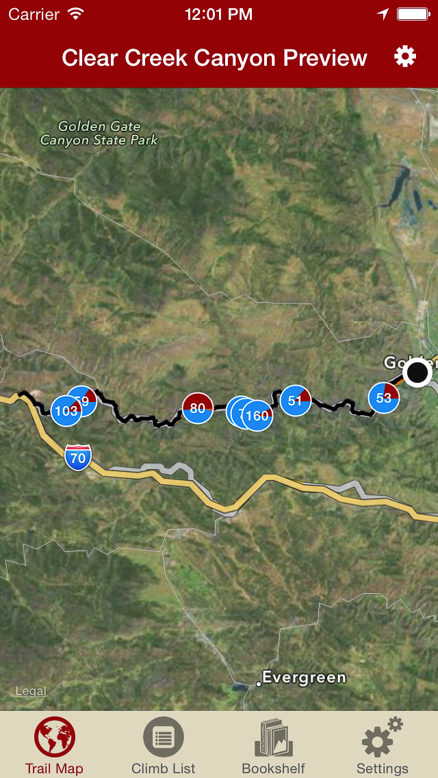
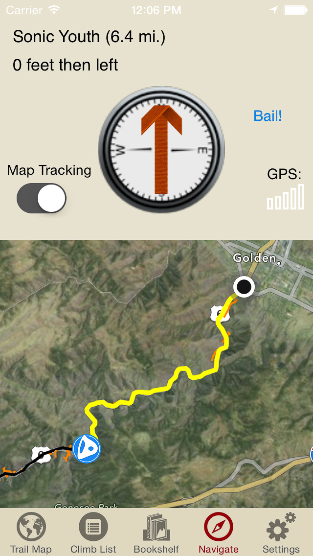
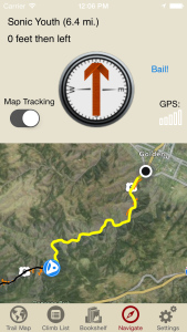
Explore Clear Creek Canyon rock climbing like it was meant to be explored, via our interactive trail map.
-
-
Navigate to all Clear Creek Canyon climbs and walls like Tod & Gordy were personally guiding you.
-
-
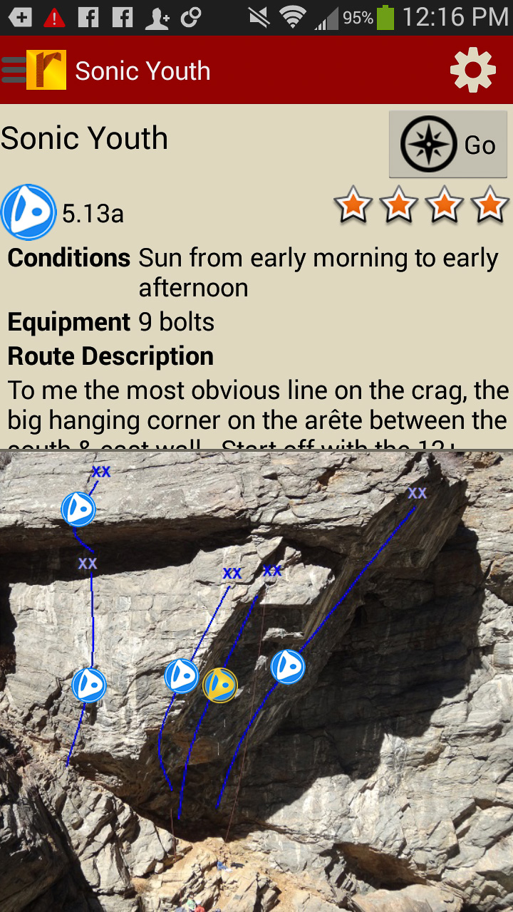
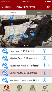
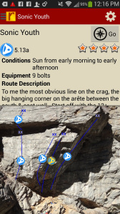
Tap on a climb to see where it’s located in the image, or tap on a route bubble in the image to see what climb it is.
-
-
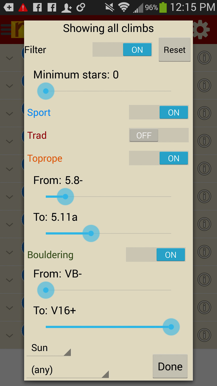
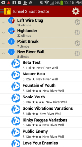
Explore Clear Creek Canyon rock climbs & walls from a hierarchical list that can be filtered and searched.
-

-
Filter the Clear Creek Canyon climbing route list or trail map by grade, climb type, quality and sun/shade times. How cool is this?
-
-
Tired of bad beta? Use local experts, Tod & Gordy Andersons’ beta to send your next Clear Creek Canyon climbing project.