by todd | Oct 31, 2016
Backcountry Skiing: Snoqualmie Pass, Washington
by Matt Schonwald
Northwest Avalanche Center
Beacon Guidebooks:
California: Tahoe Light Tours Colorado: Berthoud | Buffalo | Cameron | CO Light Tours | Crested Butte | Loveland | Marble | RMNP | Silverton New Mexico: Taos Oregon: Hood Washington: Baker | Crystal | ONP | Stevens
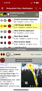
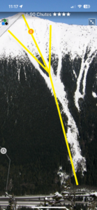
Make your tour planning more efficient and your route finding structured with the Snoqualmie Pass digital guidebook on rakkup. It shows ascent routes, descent descriptions, max slope angles, a trail map, offline GPS navigation, and much more. The information provided can help you in your decision making process through its streamlined, user friendly design.
-
-
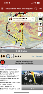
Map view
-
-
List view
-
-
Full screen photos
Buy digital plus map and the price includes $4.00 for shipping, a screaming deal! When you buy a bundle, you can use your digital rakkup guidebook immediately.
by rob | Sep 26, 2016
El Potrero Chico Rock Climbing
by Frank Madden
Potrero Chico Rock Climbing Facebook
EPC Climbing Website
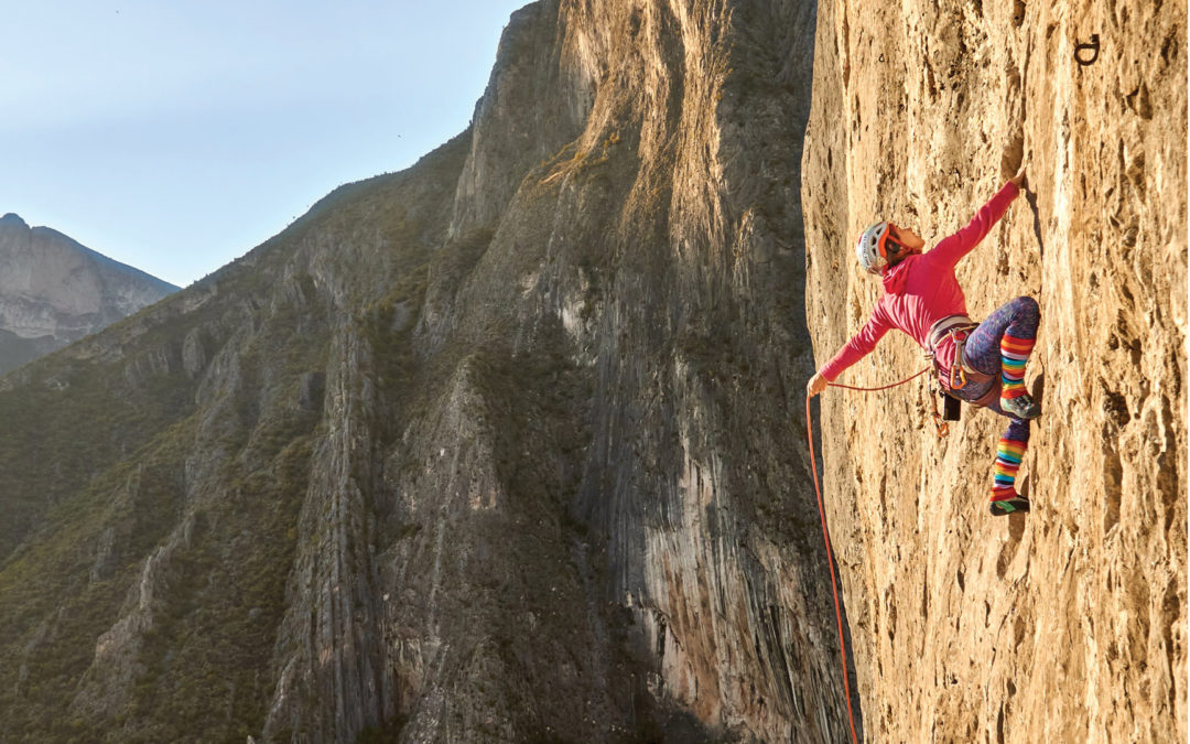
El Potrero Chico is the world’s largest big wall sport climbing destination and is home to over 600+ sport routes. Located on the outskirts of Hidalgo Nuevo Leon, Mexico, a quaint little town that has been welcoming to the climbing community since the late 80’s and early 90’s. The sharp contrast between the low of the valley where the town sits and the very tall towering walls of EPC creates a very beautiful scenic view. These limestone walls have been developed with some amazingly large routes that are bolted all the way to the top. A great place for the beginner sport climber to get into the awesome world of multi-pitch climbing. Although many of the big multi-pitch climbs are considered moderates ranging from 5.10a to 5.10d, there are several that reach into the 5.11 and 5.12 range and even a couple in the 5.13 range. So there is plenty of amazing big walls for everyone.
That being said, the single-pitch climbing in El Potrero Chico is top notch. There are amazing routes of all grades from 5.7 to 5.13. So when you need a rest from scaling the massive walls, enjoy some of the cragging that is available in some of the other single pitch crags. Outrage wall, The Surf Bowl and Estrellas Canyon are well known for some amazing single pitch climbing.
The style of rock here is mostly slab/vertical face with a couple of crags that hold some beautiful overhanging steep climbing. The Lower Sense of Religion (better known as Moto Wall) and The Virgin Canyon have some of the best single pitch face climbs in the area. If you are looking for something different though, The Surf Bowl and Outrage Wall will be your best friend if you want to get on some awesome overhanging tufas while you are visiting. The weather down here is great during the winter and prime sending temps last for months. During the summer the sun situation changes for most of the crags and the hot Mexican sun pelts the walls with wicked hot rays. Find the shade!! With the climbing areas on mostly north or south facing walls you can always find shade when it’s hot outside.
A small part of the local community has stepped up to provide all the amenities necessary for an amazing climbing trip. When you are in need of a serious rest day there is plenty to enjoy at the campgrounds and around town. Plenty of good places to eat, a hot springs location about an hour’s drive from Hidalgo, the city of Monterrey if you are looking for some excitement and El Buho Cafe if you are looking for a great place to lounge, relax and sip some amazing coffee. Take the time to walk around town and check out the local community.
The towering limestone walls reach towards the skies while the mariachi music blares through the canyon with locals and climbers alike taking in the beauty of the climbing. Don’t be surprised when the locals come up and try to chat with you or even have a beer with you at the crag. They love seeing the “crazy” climbers up on the rock enjoying the beautiful place they live in. Before long you’ll be dancing to the mariachi music with whatever strength you have left from the amazing climbing here.
The guidebook for El Potrero Chico is being updated regularly a few times a year by the author who spends his winter months hiding from the snow by climbing and exploring more of the surrounding areas.
Buy both versions of the guidebook (print and digital) for only $53.99! That price includes $10.00 for shipping, meaning that you get the book for only $31 more! A screaming deal on a beautiful guidebook!
-
-
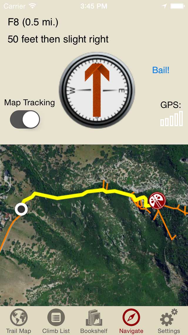
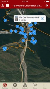
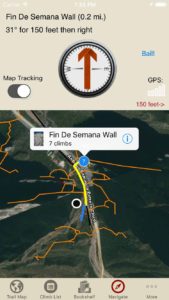
Explore El Potrero Chico’s climbing like it was meant to be explored via our interactive trail map.
-
-
rakkup guides you car to your crag then shows you a picture when you arrive. Awesome.
-
-
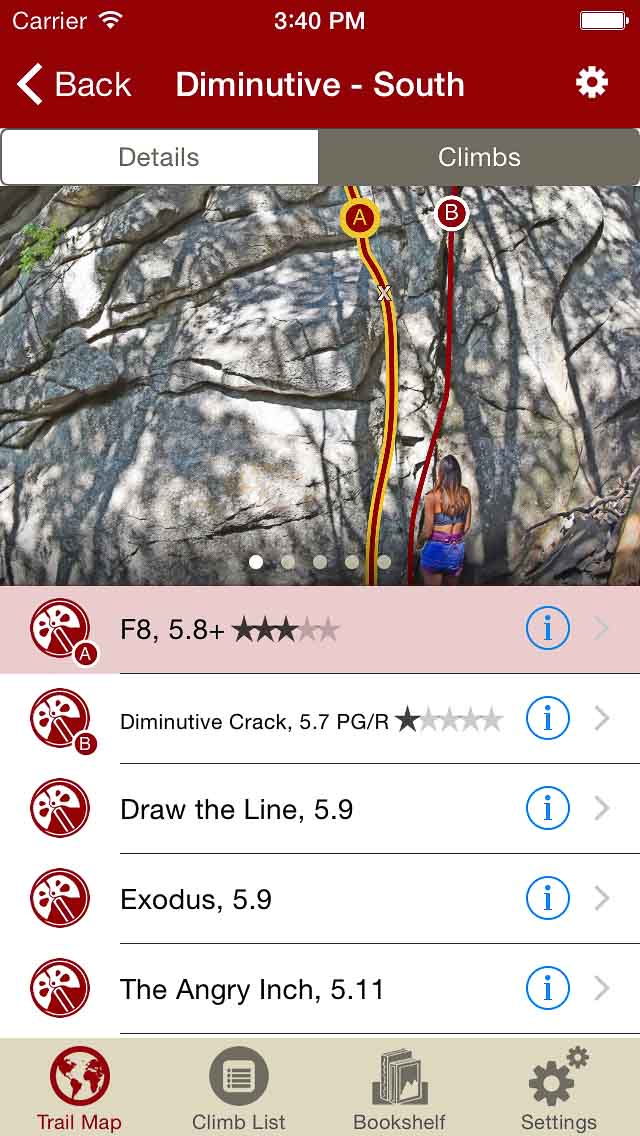
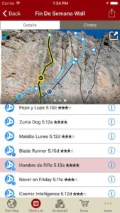
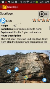
Smart topos find your line.
-
-
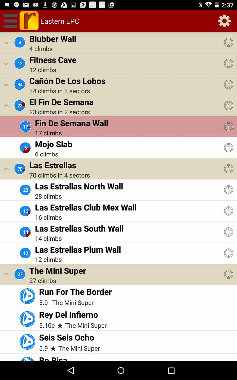
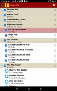
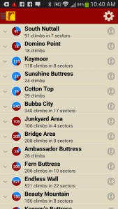
All those El Potrero Chico climbs in a searchable list.
-
-
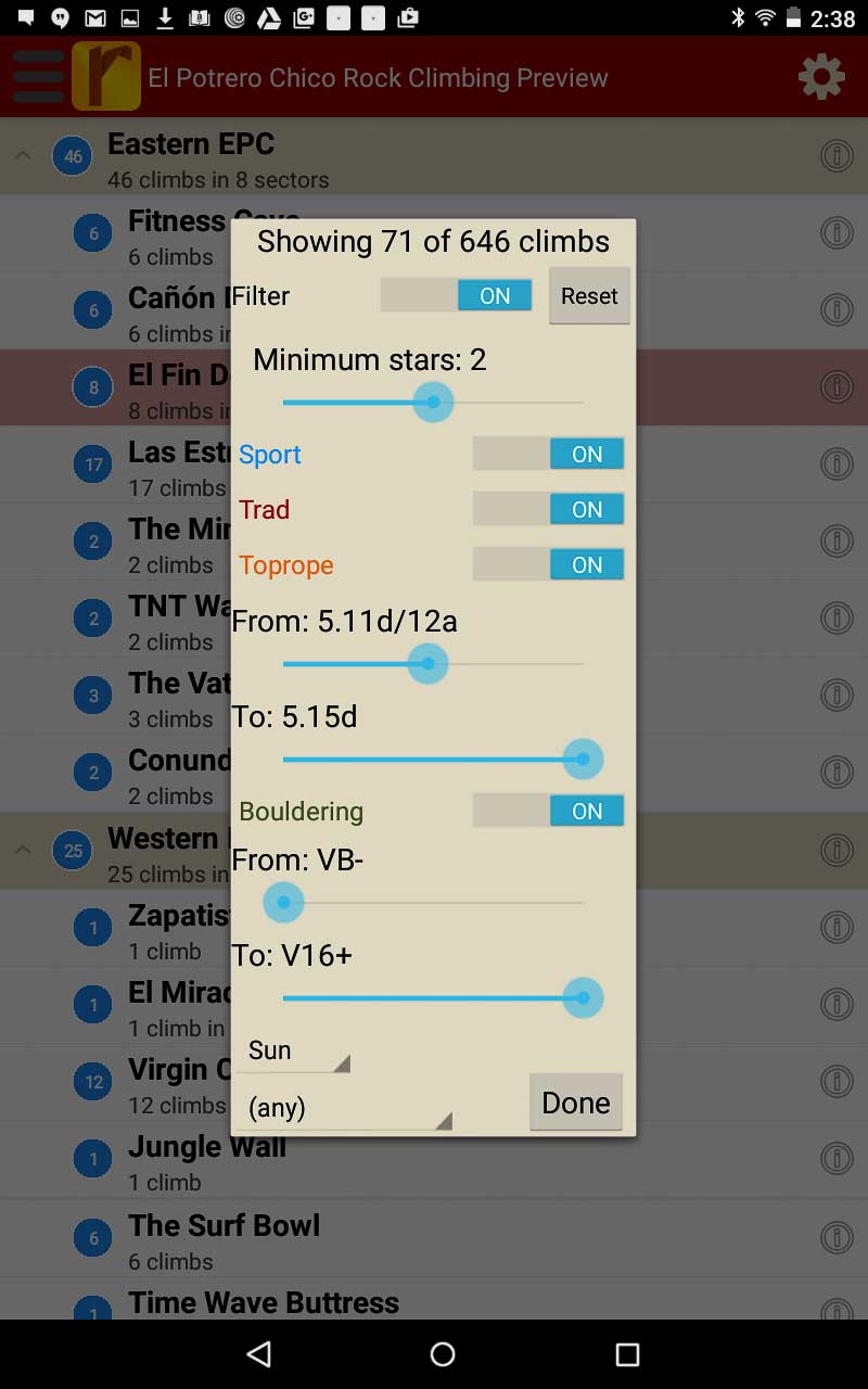
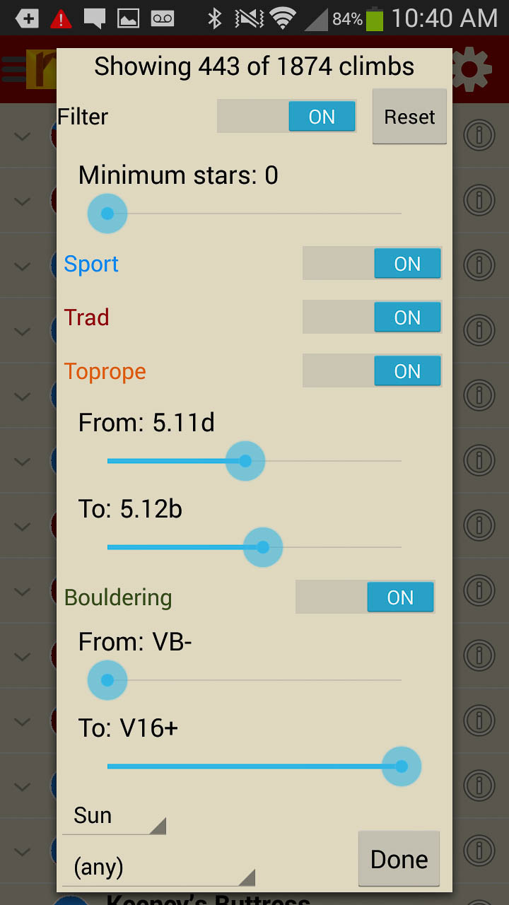
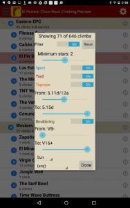
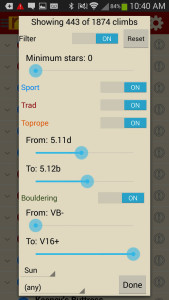
Filter climbs to show only the grades you want to see, or map where the highest quality climbs are found!
-
-
Tired of bad beta? Use Frank’s beta to send your next proj!
by todd | Sep 2, 2015
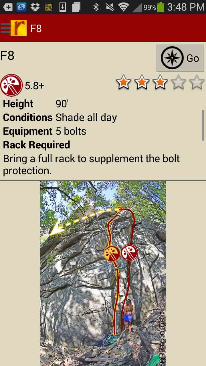
Ferguson Canyon Rock Climbing
by Tony Calderone
Little Cottonwood Climbing | Big Cottonwood Climbing | Wasatch Front Bouldering | Wasatch Wilderness Climbing | Wasatch Bench Climbing
Ferguson Canyon is located between Big Cottonwood and Little Cottonwood Canyons, near Salt Lake City, Utah. The canyon is known for its welcoming atmosphere. Nearly all the routes are shaded all day long. In contrast to most local climbing areas, dogs are allowed here. Most of the routes are short, averaging 50 feet in length. And the nearby stream provides a swamp-cooling effect. With 160 routes to choose from, you will enjoy climbing here with the excellent beta provided by long-time local guide, Tony Calderone.
-
-
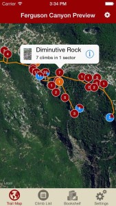
Explore Ferguson Canyon like it was meant to be explored via our interactive trail map.
-
-
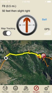
rakkup guides you car to crag then shows you a picture when you arrive. Awesome.
-
-
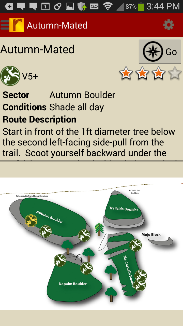
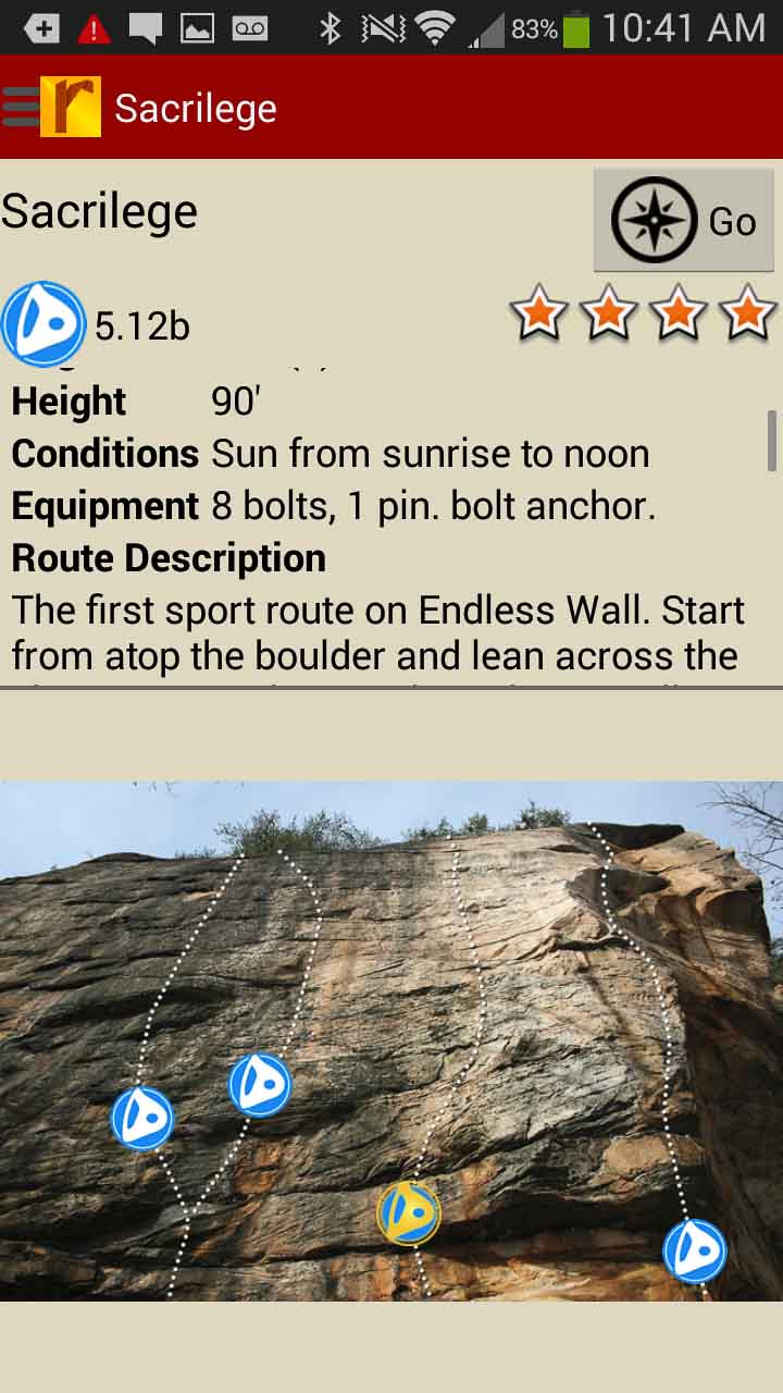
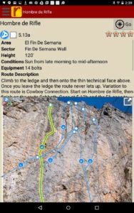
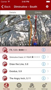
Tap on a climb name, see where it’s located on the image. Tap on a climb bubble in the image, discover what climb it is. So nice…
-
-
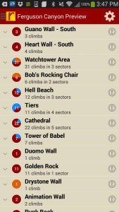
Over 160 and growing Ferguson climbs at your fingertips.
-
-
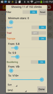
Too much to handle? Sort all those climbs to only the grades you want to see. Too hot? No prob, filter by in shade only.
-

-
Tired of bad beta? Use local guide, Tony Calderone’s beta to send your next proj!
Print + digital bundle pricing includes $6.00 for shipping.
by todd | Jan 20, 2015
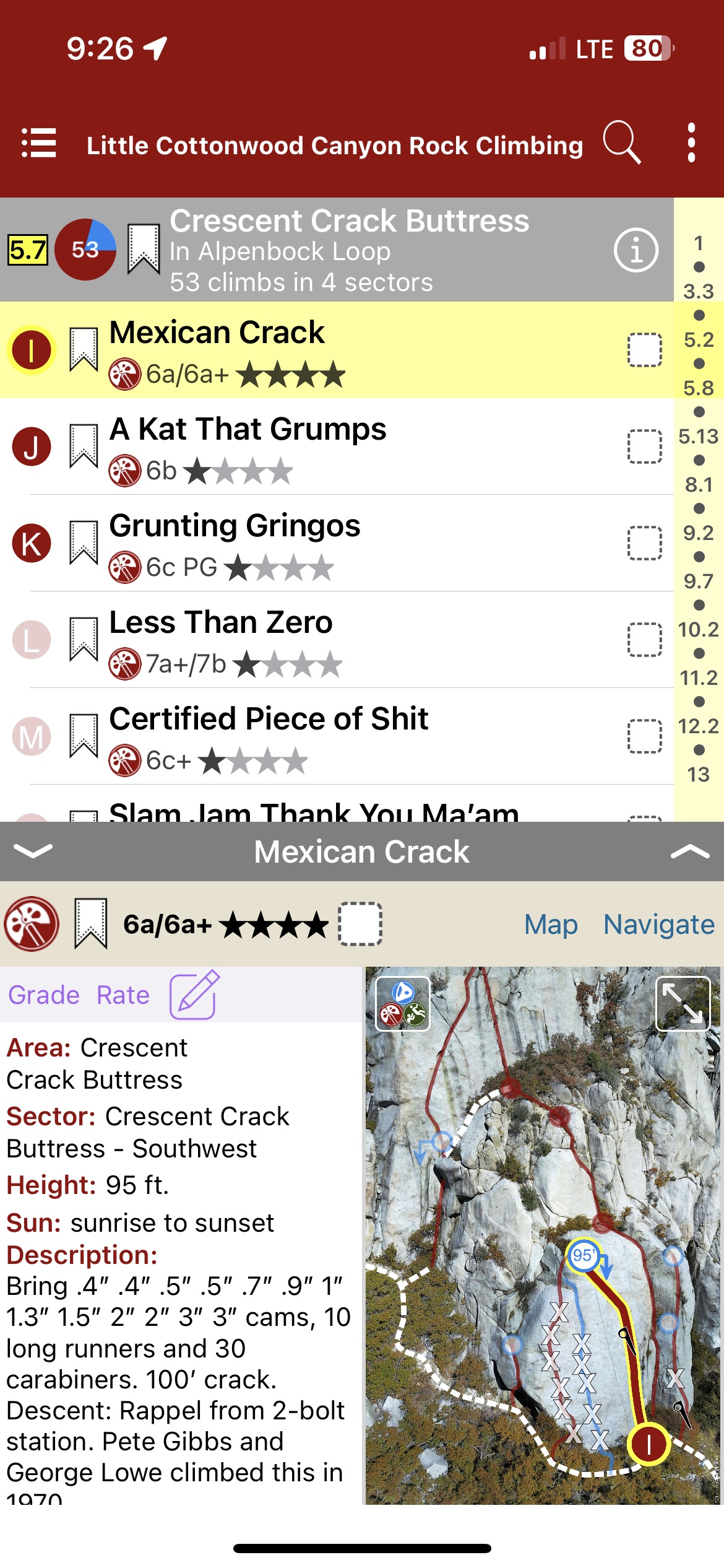
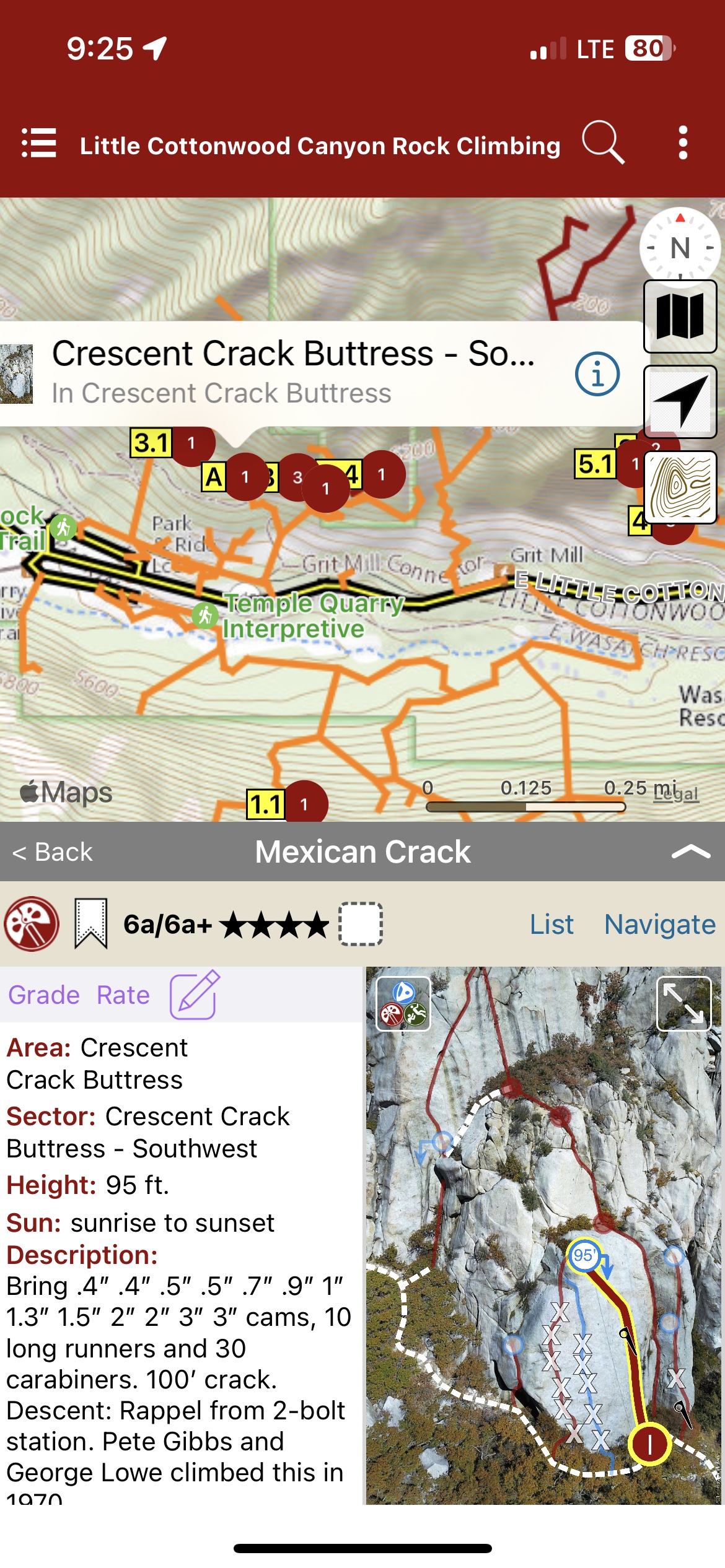
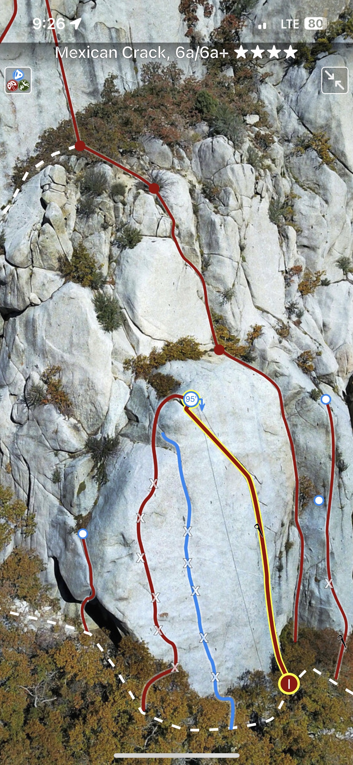
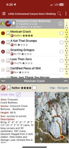
Little Cottonwood Rock Climbing
by Tony Calderone
Wasatch Front Bouldering | Big Cottonwood Climbing | Ferguson Canyon | Wasatch Wilderness Climbing | Wasatch Bench Climbing
Twenty minutes from downtown Salt Lake City lies the largest concentration of rock climbs in Utah. The true gem of Wasatch rock climbing. Little Cottonwood Canyon Rock Climbing!
Little Cottonwood Canyon is located within the Wasatch-Cache National Forest along the eastern border of the Salt Lake Valley, where the Rocky Mountains meet the Great Basin, roughly twenty miles southeast of Salt Lake City, Utah.
The canyon is a popular sightseeing destination and is a glacial trough carved by an alpine glacier during the last ice age, approximately 15,000 to 25,000 years ago. Albion Basin is famous for wildflowers and is one of the most photographed areas in northern Utah. Rare and endemic plant species are found in the area. Mountain goats inhabit the surrounding mountains.
Recreational activities in Little Cottonwood Canyon include hiking, camping, fishing, mountain biking, rock climbing, skiing, snowboarding, and backcountry use. There are two resorts in the canyon, Alta and Snowbird, providing both summer and winter recreational opportunities. The Utah Native Plant Society often conducts wildflower walks at Albion Basin and in other locations in the canyon. The paved portion of the road is approximately 8.3 miles from the base of the canyon to the top with an average grade of 9.2%, making it a popular road cycling challenge.
The lower third of the canyon is strewn with quartz monzonite outcroppings, mostly consisting of smooth steep faces. Local climbers informally refer to the rock as granite, which is a close relative.
Approaches involve parking along the road and hiking up through scrub oak, talus fields and large boulders.
Face climbing is the predominant technique, typically using a mixture of pre-placed bolts and cracks for protection, but there are many notable pure crack climbs as well. Most routes are 200-600 feet long, but routes of over 2,000 feet in length exist.
There is a long history of local community groups climbing in the canyon. Some notable groups through the years include: The Wasatch Mountain Club, The Alpenbock Club, The Steinfell Climbing Club and University of Utah climbing classes
The historical representation communicated herein endeavors to be an accurate picture of what happened in the past without sentimentality. This style of presentation necessarily risks hurting the feelings of those in the present. It also focus on facts and steer firmly away from assumptions, conjecture or opinion… which is always biased. You may find this approach to be of a decidedly old-fashioned style that lacks the snarkiness more common in modern works.
Consider, as you climb, that the rock was not nearly so clean of vegetation, flakes, dirt or massive loose blocks. Many of the earliest ascents were done without the aid of topropes, power drills, spring-loaded cams, sticky rubber shoes or harnesses. And ropes and bolts were not infailable.
Some of the most tame approach trails we saunter up in a few minutes today used to be far more time-consuming and energy-draining just a few decades ago. Consider, also, that guidebooks were far less informative or did not exist at all.
One of the worst errors of the present – not just ours, but any present – is its tendency to condescend toward the past, which is much easier to do when one does not seek to grasp the nature of its challenges as they presented themselves at the time.
This small book is, in part, an effort to counteract that condescension and remind us of how remarkable were the achievements of those who came before us. May it lead you to reconsider what is routinely called “progress” and recognize that humility is more a byproduct of conscious living than a whole-cloth creation.
This work is offered as a contribution to the making of Wasatch Climbers. As such, it is a loving endeavor as well as a scholarly one, without losing sight of what there is to celebrate and cherish in your achievement.
With Sincerity,
Tony
-
-
List view
-

-
Map view
-

-
Full screen topos
Print + digital bundle pricing includes $6.00 for shipping.
by todd | Oct 24, 2014
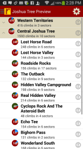
Joshua Tree Rock Climbs
Wolverine Publishing
by Robert Miramontes
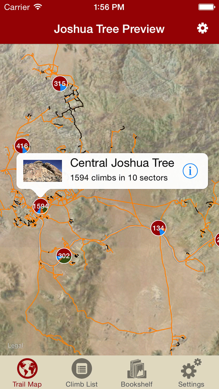
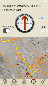
Welcome to one of Earth’s great playgrounds of stone—Joshua Tree National Park. World renowned for its bold and pure trad climbing, its monumental volume and variety of easy and moderate routes, and the other-worldly ambiance of its landscape. This digital rock-climbing guide presents the entire park, describing 3000 of the finest climbs, including several of the better bouldering circuits. The entire trail map to Joshua tree has been meticulously mapped to enable rakkup’s turn-by-turn directions from car to crag. Imagine never getting lost at Joshua Tree again. Is that even possible? It is with Robert’s Joshua Tree rakkup guidebook. The Joshua Tree trail map by itself is worth this price, let alone 3000 route descriptions with beautiful color topo images.
-

-
Imagine never being lost at Joshua Tree again. Robert’s Joshua Tree trail map will blow you away. You have to experience this trail map to understand how groundbreaking this is.
-
-
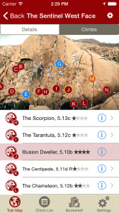
Navigate to over 3000 climbs, like Robert Miramontes was showing you the way to every crag at Joshua Tree.
-
-
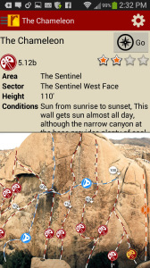
Tap on a climb to see where it’s located in the image, or tap on a route bubble in the image to see what climb it is.
-
-
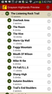
Explore Joshua Tree Rock Climbs from a hierarchical list that can be filtered and searched.
-

-
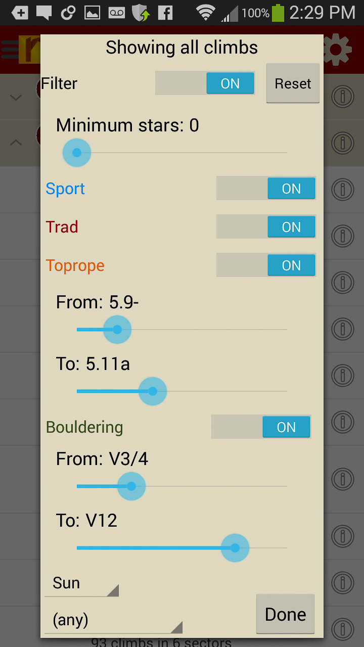
Filter the 3000+ climbing route list or trail map by grade, climb type, quality and sun/shade times. How cool is this?
-
-
Tired of bad beta? Use local expert, Robert Miramontes beta to send your next Joshua Tree climbing project.
Digital + print edition pricing includes $6.00 for shipping.
by todd | Aug 27, 2014
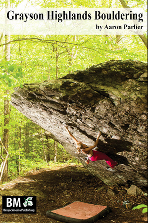
Grayson Highlands Bouldering
Brayackmedia Publishing
by Aaron Parlier
Grayson Highlands Bouldering Blog
Grayson Highlands Bouldering Facebook
Grayson Highlands State Park (GHSP) is the uncontested crown jewel of Virginia in terms of scenery, hiking, and nearly all facets of outdoor recreation. Grayson is the best bouldering area in the Southeast. Don’t believe us? Learn why here. In GHSP there are problems ranging from easy going to V-insane. This digital guide for Android, iPhone & iPad devices has 349 of the the best problems and Aaron will be adding more problems in updates.
Print + digital bundle pricing includes $6.00 for shipping. The print guidebook sold with the “Digital + Print edition” bundle is the 2013 edition.
-

-
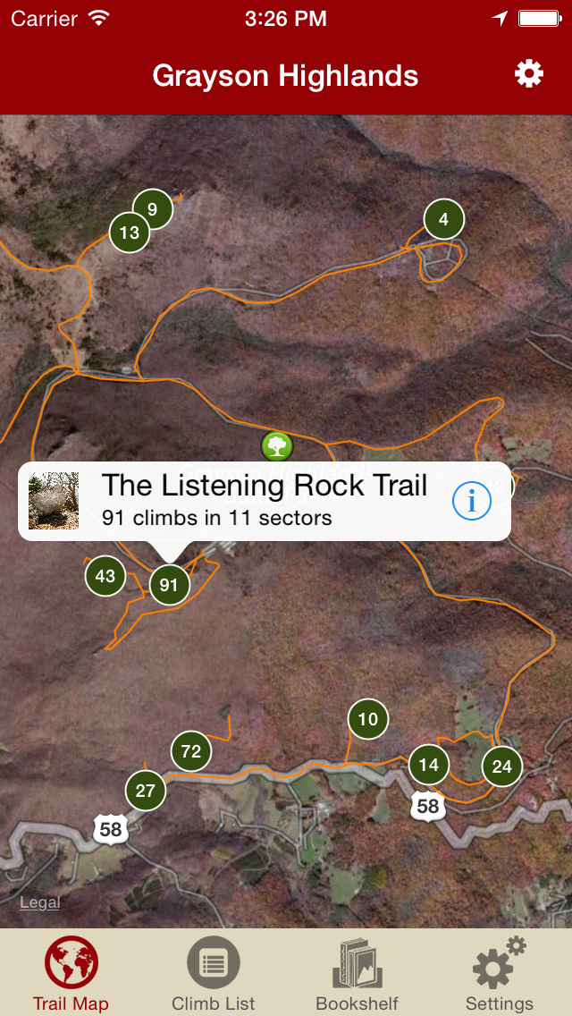
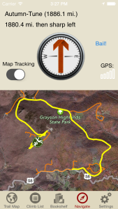
Explore Grayson like it was meant to be explored via our interactive trail map.
-
-
Then just like Aaron Parlier was showing you how to get to his latest secret problem, rakkup guides you turn by turn to your boulder then shows you a picture when you arrive. Awesome.
-
-
Beautiful hand drawn topos. Tap on a problem name, see where it’s located on the topo. Tap on a problem bubble in the topo, discover what problem it is. So nice…
-
-
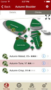
Over 400 of the best problems at Grayson right at your finger tips.
-

-
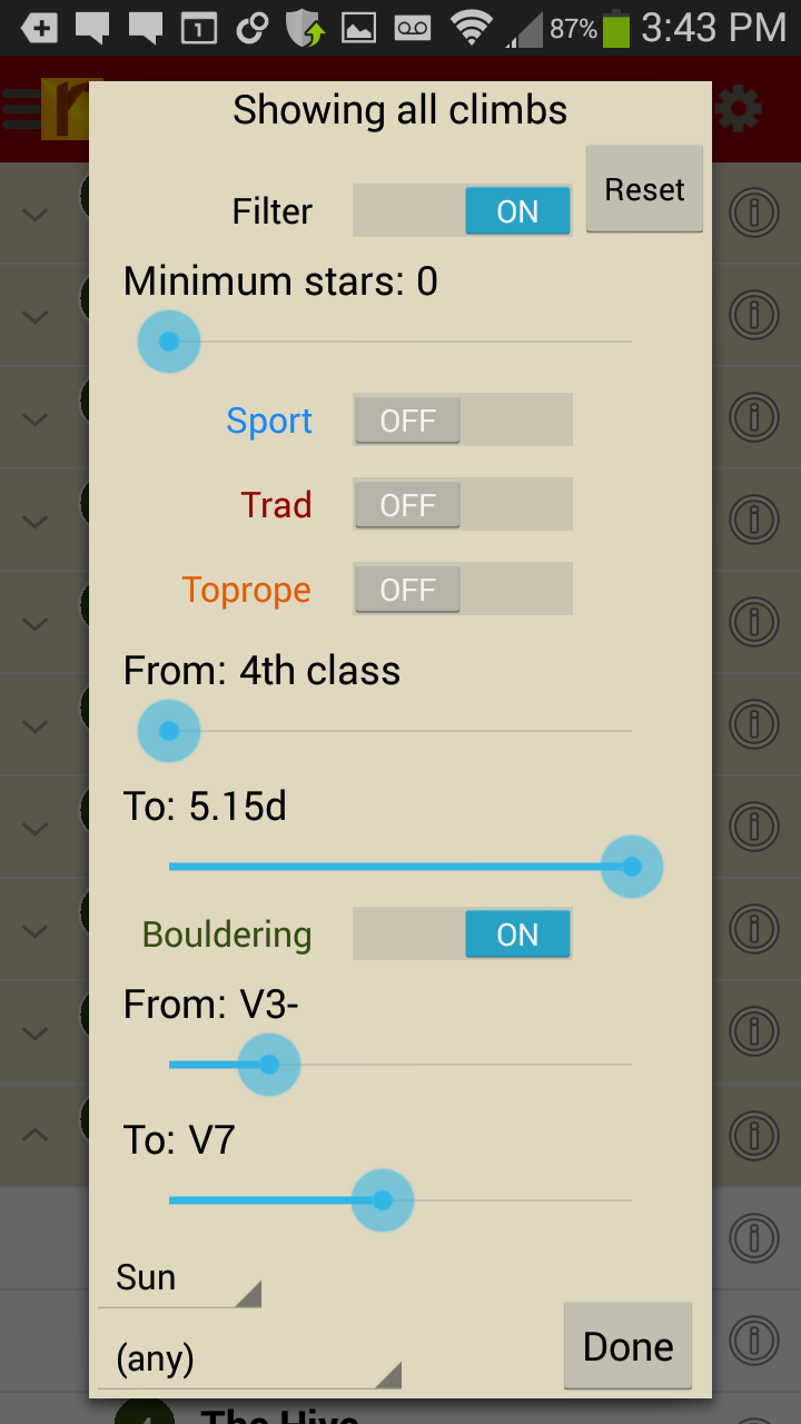
Too much to handle? Sort all those problems to only the grades you want to see. Too hot? No prob, filter by in shade only.
-

-
Tired of bad beta? Use local expert, Aaron Parlier’s beta to send your next proj!
by rob | Mar 17, 2014
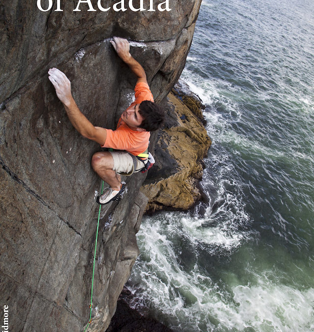
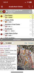
Rock Climbs of Acadia
by Grant Simmons
Rock Climbs of Acadia Facebook
Grant’s Rock Climbs of Acadia website
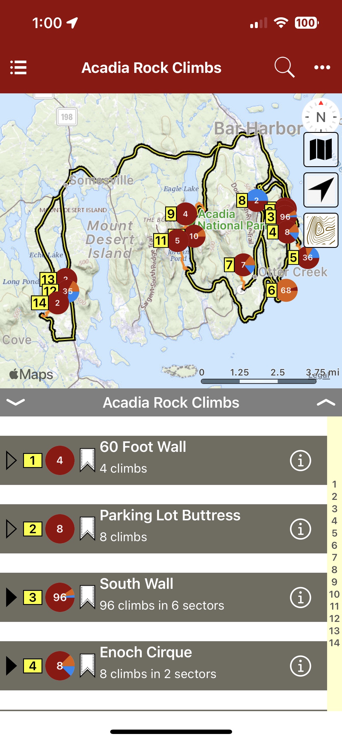
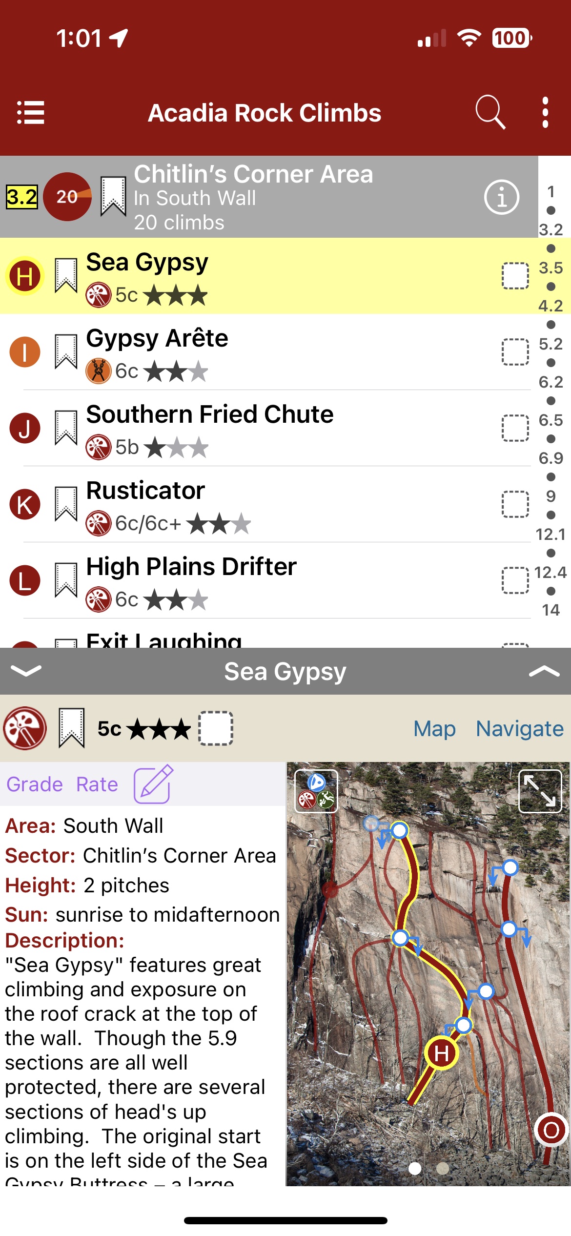
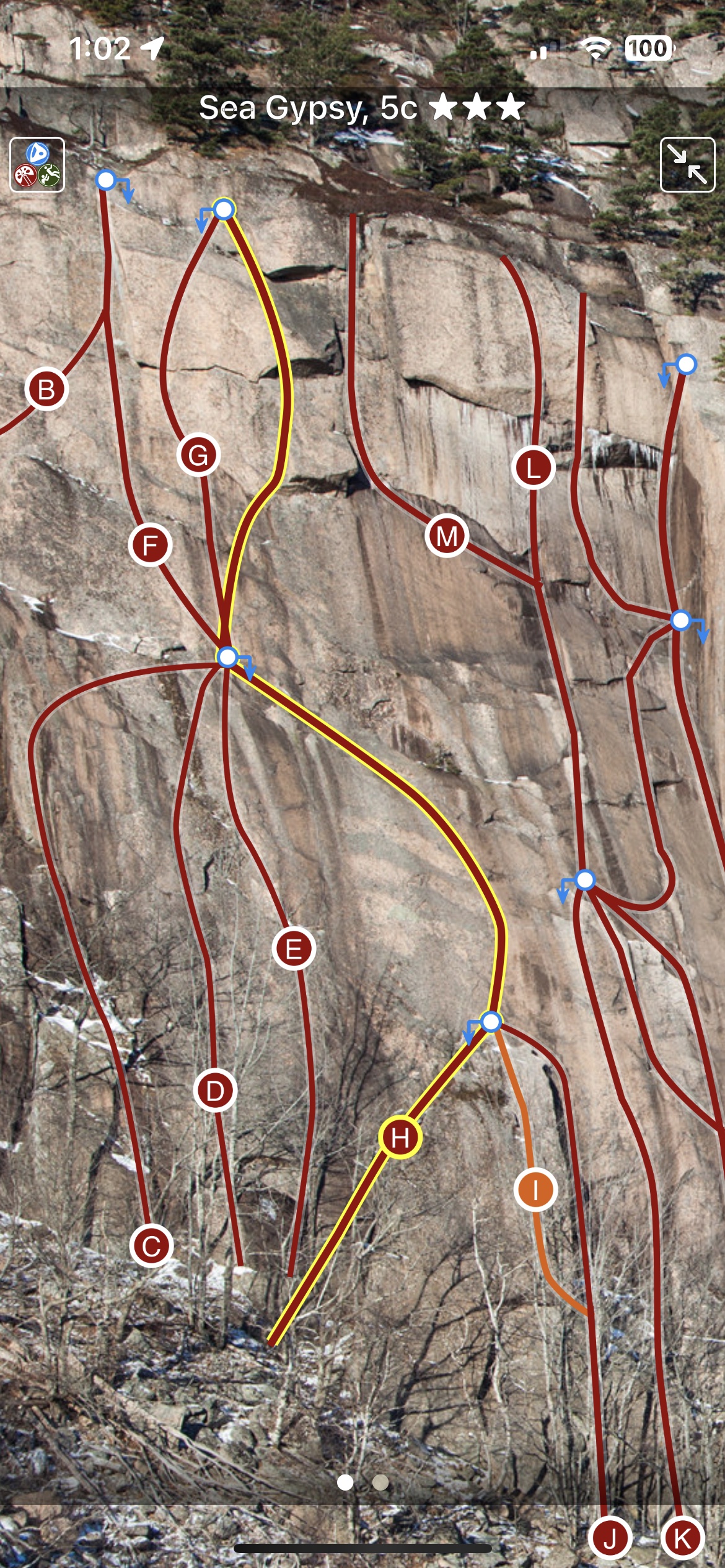
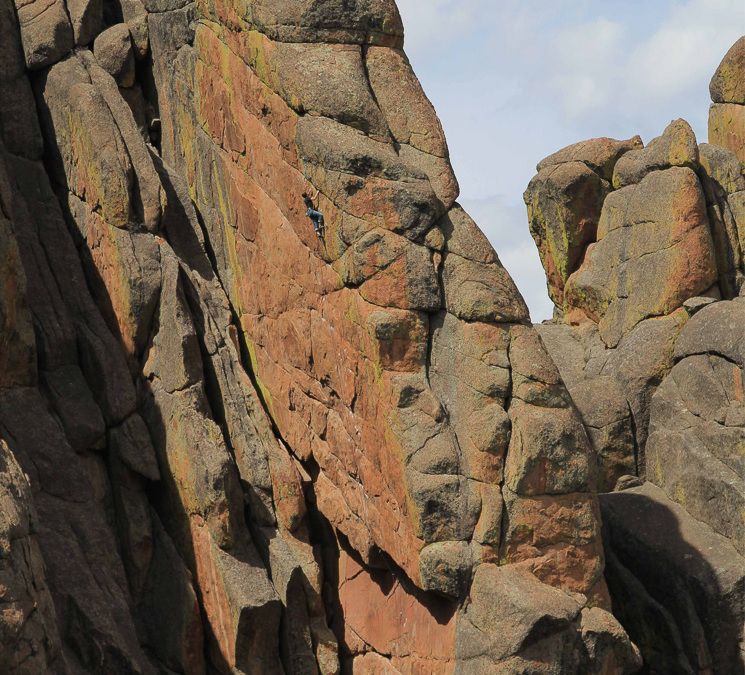
One of the East Coast’s premier summer destinations. Acadia National Park offers high quality granite climbing in a spectacular setting. It is a Downeast island paradise replete with classic routes both on the coast and inland. Rock Climbs of Acadia, more up to date than the print guidebook, covers over 280 climbs in all the classic climbing areas, plus many of the island’s more obscure haunts.
Learn why Acadia Rock Climbing is truly an island paradise here. Check out Grant’s Rock Climbs of Acadia site here.
-
-
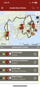
Map view
-
-
List view
-

-
Full screen topos
Buy digital plus book and the price includes $13.00 for (USA domestic) shipping, a terrific deal compared to buying them separately! When you buy a bundle, you can use your digital rakkup guidebook immediately. Then check your email for instructions about shipping.
by todd | Mar 17, 2014
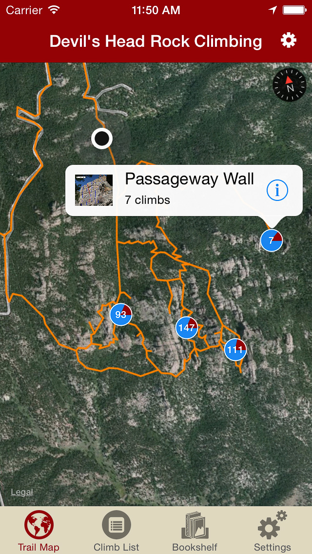
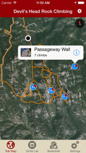
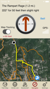
Devil’s Head Colorado Digital Climbing Guide
by Tod Anderson
Devil’s Head Facebook
Overlooked or ignored for many years, Devil’s Head rock climbing has become one of Colorado’s premier sport climbing destinations. Over 100 crags, spires and walls contain some of the best granite in the western U.S., and there are now over 1000 climbs at Devil’s Head and Tod is updating this guidebook with new routes regularly.
Devil’s Head features great views and a feeling of remoteness, despite being only an hour from downtown Denver. Most crags require some walking to access, but the hikes are generally over moderate terrain and elevation gains are reasonable. It’s easy to find sun or shade as needed, depending on the daily temperatures. Each crag has its own unique character and a wide variety of types of climbing are found at the always expanding collection of crags at Devil’s Head.
Both free and pay camping are available in the vicinity and some sites even feature walk from camp climbing access. Pay camping exists at the main trailhead in a small campground that has about 15 sites. Those often fill up on weekends, so early weekend arrival is advised. Free dispersed camping is allowed along Rampart Range Road and in Jackson Creek valley. The best sites are located past the turnoff to the main trailhead and beyond Mile Marker 10.
-
-
Explore Devil’s Head rock climbing like it was meant to be explored, via our interactive trail map.
-
-
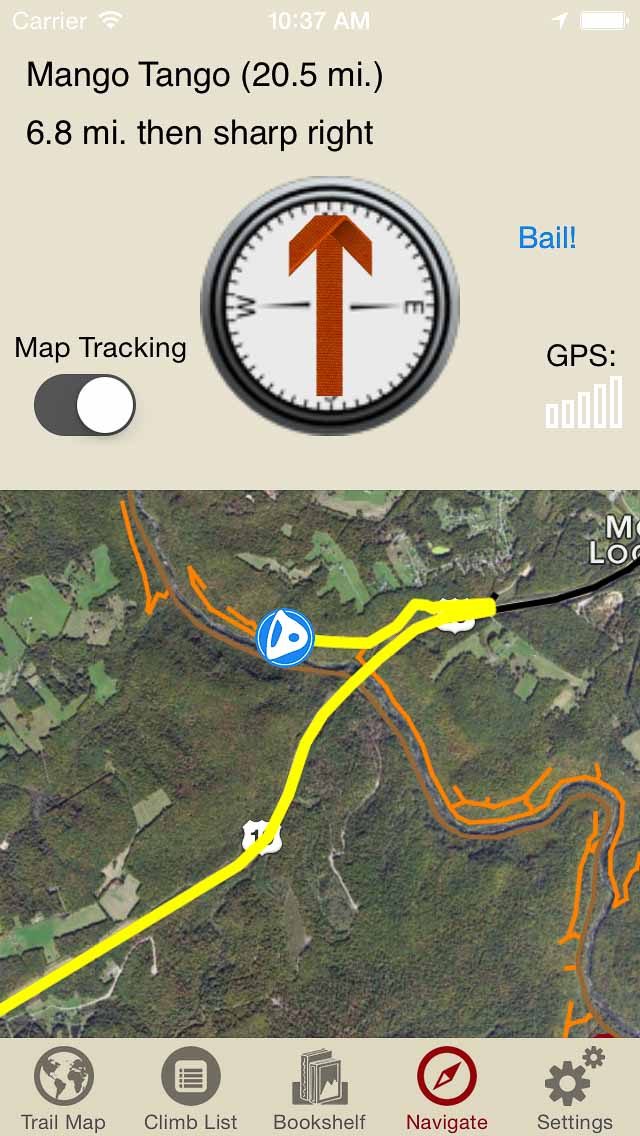
Navigate to all Devil’s Head climbs and walls like Tod was personally guiding you.
-
-
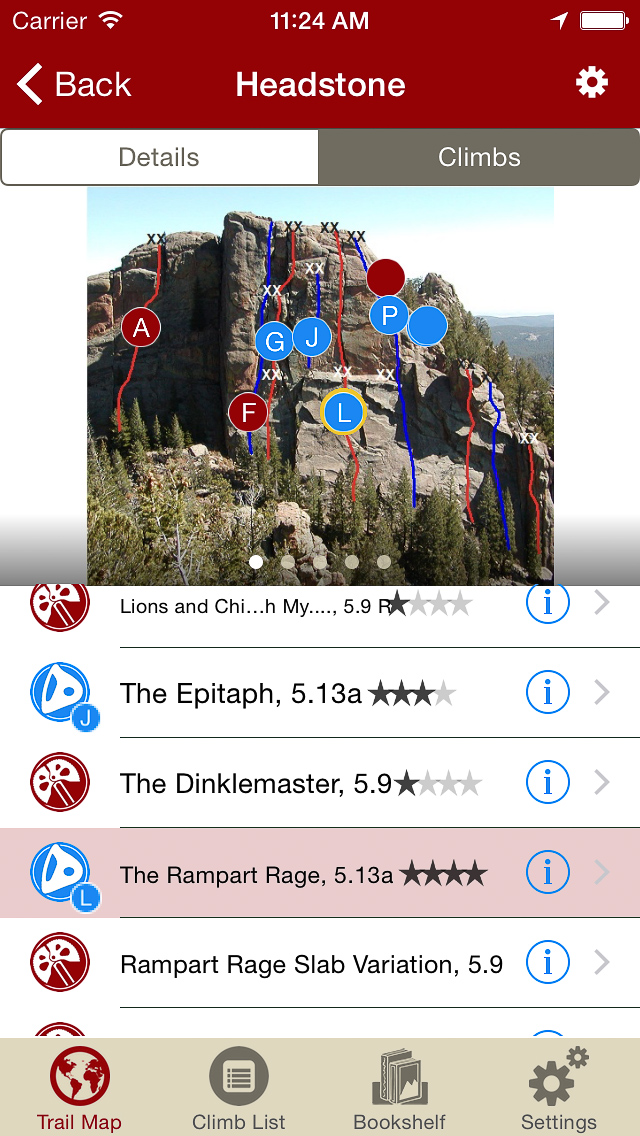
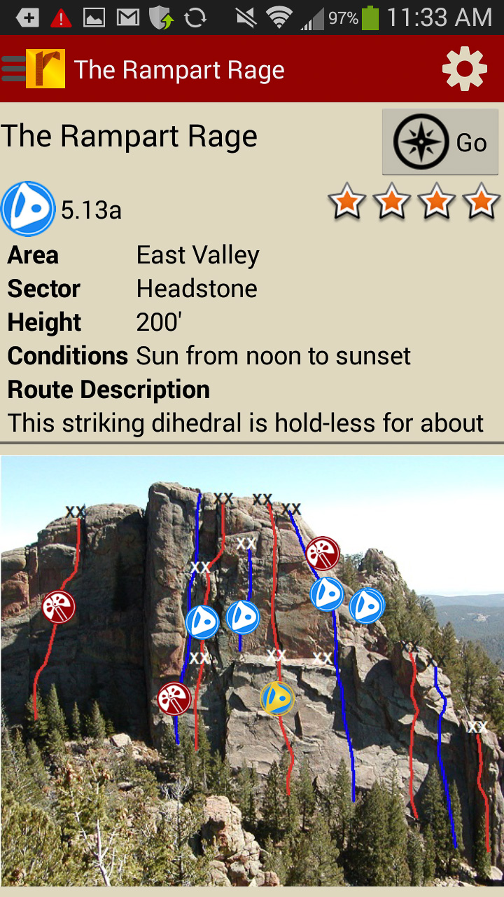
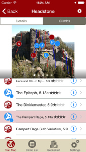
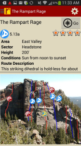
Tap on a climb to see where it’s located in the image, or tap on a route bubble in the image to see what climb it is.
-
-
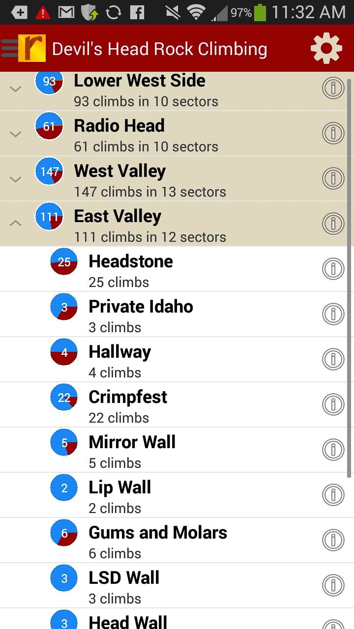
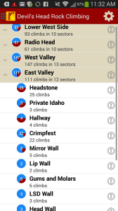
Explore Devil’s Head rock climbs & walls from a hierarchical list that can be filtered and searched.
-
-
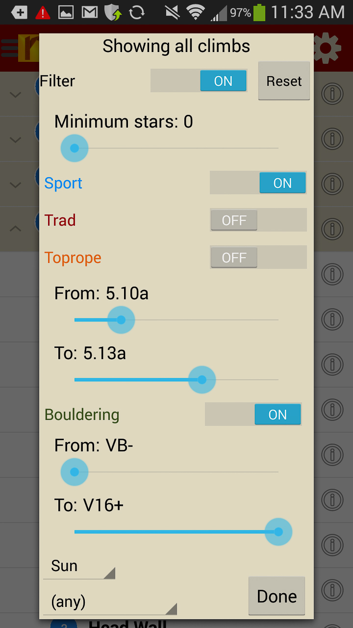
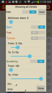
Filter the Devil’s Head climbing route list or trail map by grade, climb type, quality and sun/shade times. How cool is this?
-
-
Tired of bad beta? Use local expert, Tod Anderson’s beta to send your next Devil’s Head climbing project.
Print + digital bundle pricing includes $7.00 for shipping.
by todd | Mar 17, 2014
New River Rock Volume 2
Wolverine Publishing
by Mike Williams Mike’s Iron Clad Beta Blog
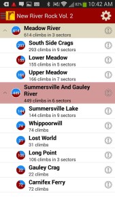
Long overshadowed by the more famous New River Gorge just a few miles to the south, the Meadow River, Summersville Lake, and Gauley River harbor an equally diverse selection of some of America’s best rock climbs. This digital guidebook (more up to date than print) documents over 1100 sport and traditional routes in these beautiful sandstone areas. Entertaining route descriptions, full color photos, complete trail map enabling turn-by-turn navigation to the crag and up-to-date beta are all found in the first ever digital guidebook dedicated to the world class climbing of the Meadow River, Summersville Lake, and Gauley River.
Print + digital bundle pricing includes $6.00 for shipping.
Don’t forget to check New River Rock Vol. 1 for more coverage of this amazing area!
-
-
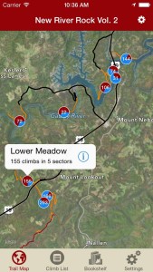
Explore Gauley, Meadow and Summersville like they are meant to be explored via our interactive trail map.
-

-
Then just like Mike Williams was showing you how to get to his latest secret project, rakkup guides you car to crag then shows you a picture when you arrive. Awesome.
-
-
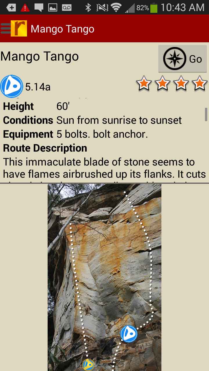
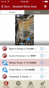
Tap on a climb name, see where it’s located on the image. Tap on a climb bubble in the image, discover what climb it is. So nice…
-
-
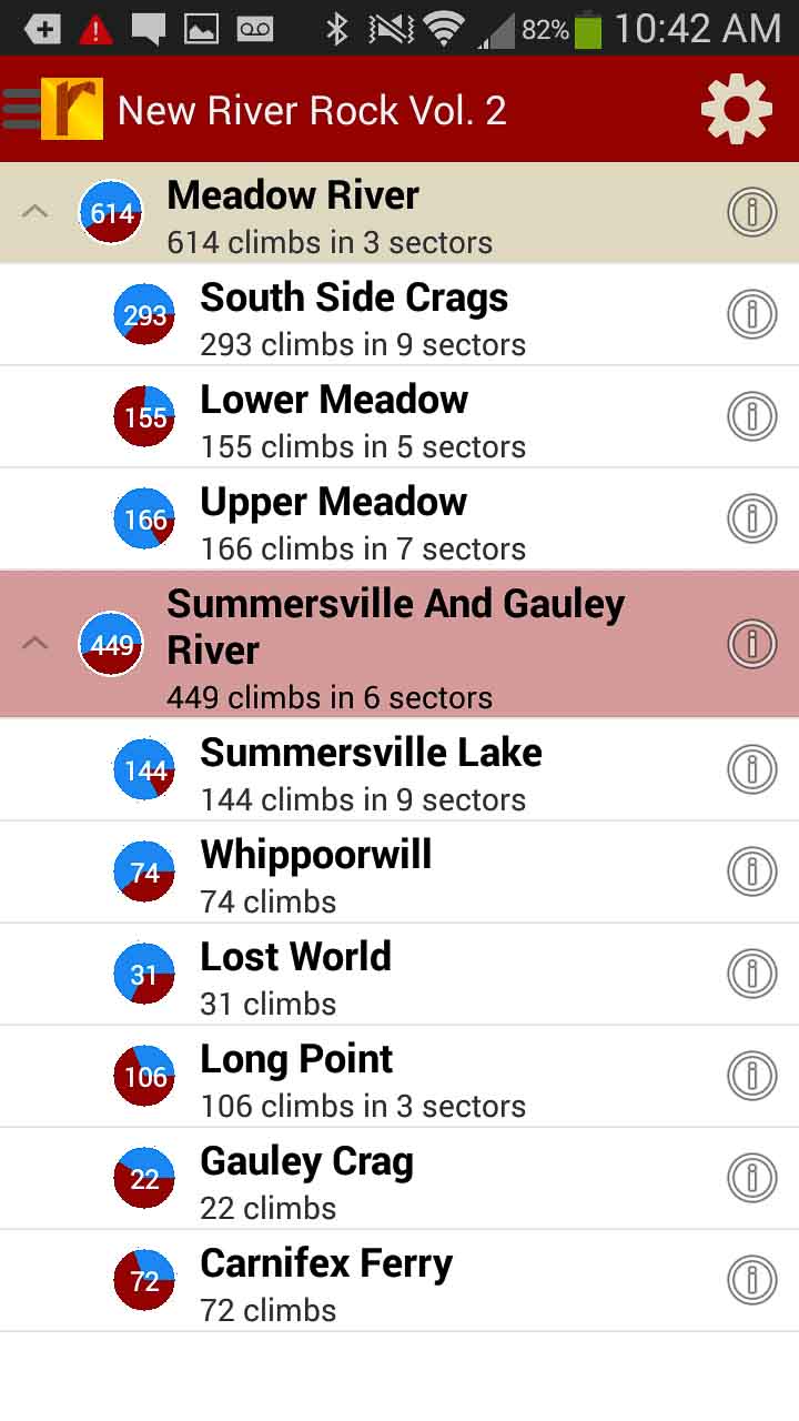
Over 1000 Gauley, Meadow & Summersville climbs at your fingertips
-
-
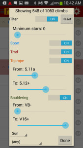
Too much to handle? Sort all those climbs to only the grades you want to see. Too hot? No prob, filter by in shade only.
-
-
Tired of bad beta? Use local expert, Mike William’s beta to send your next proj!
by todd | Mar 17, 2014
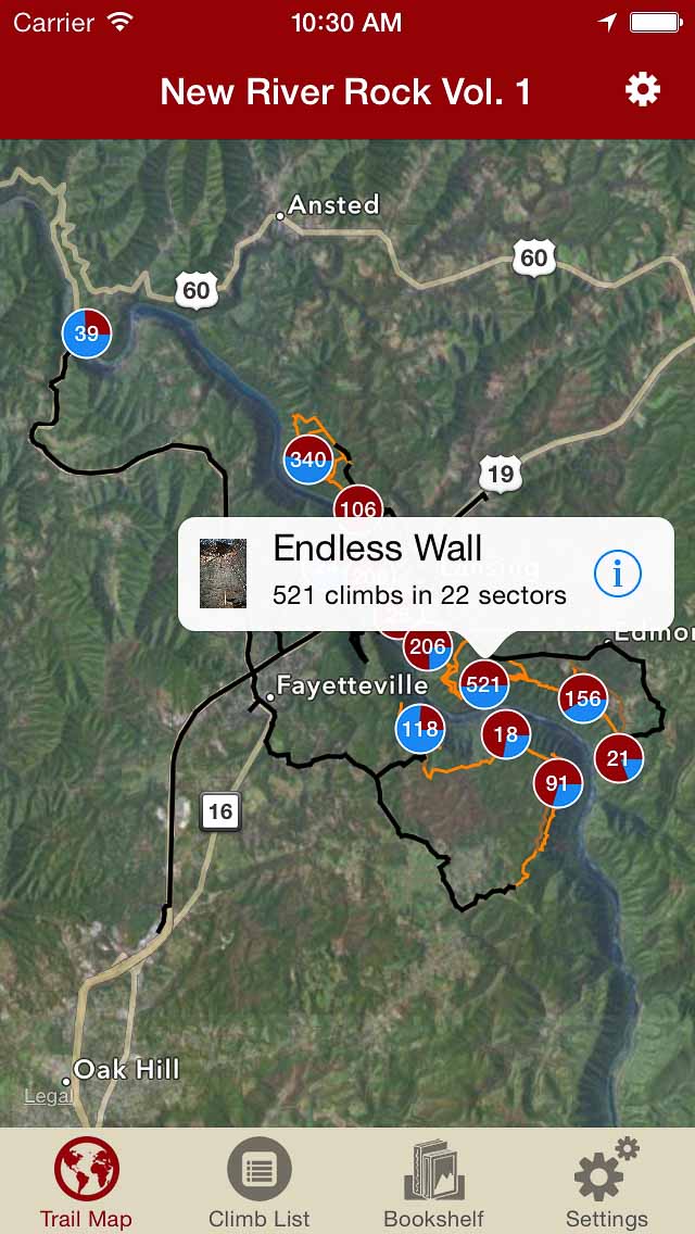
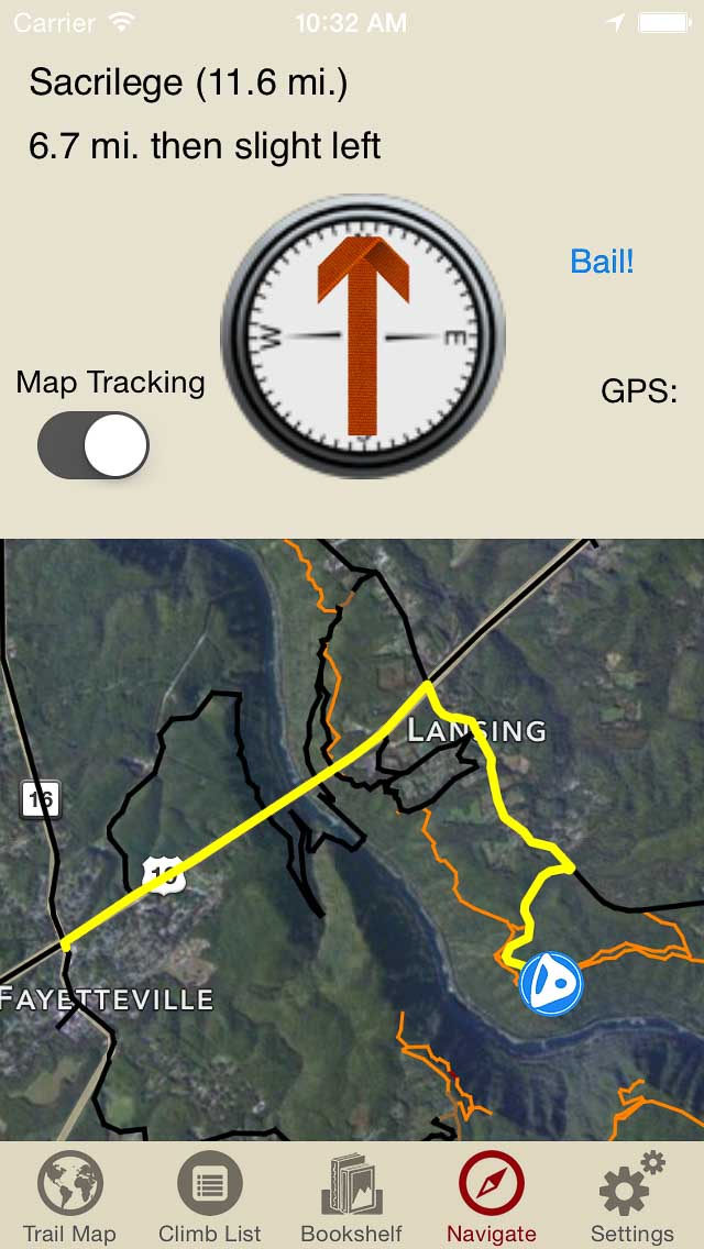
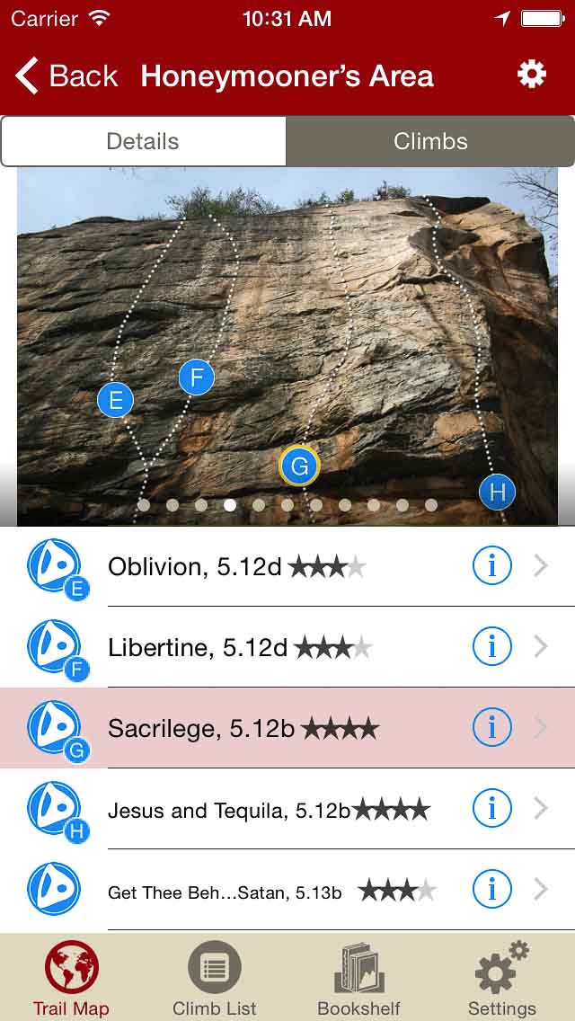
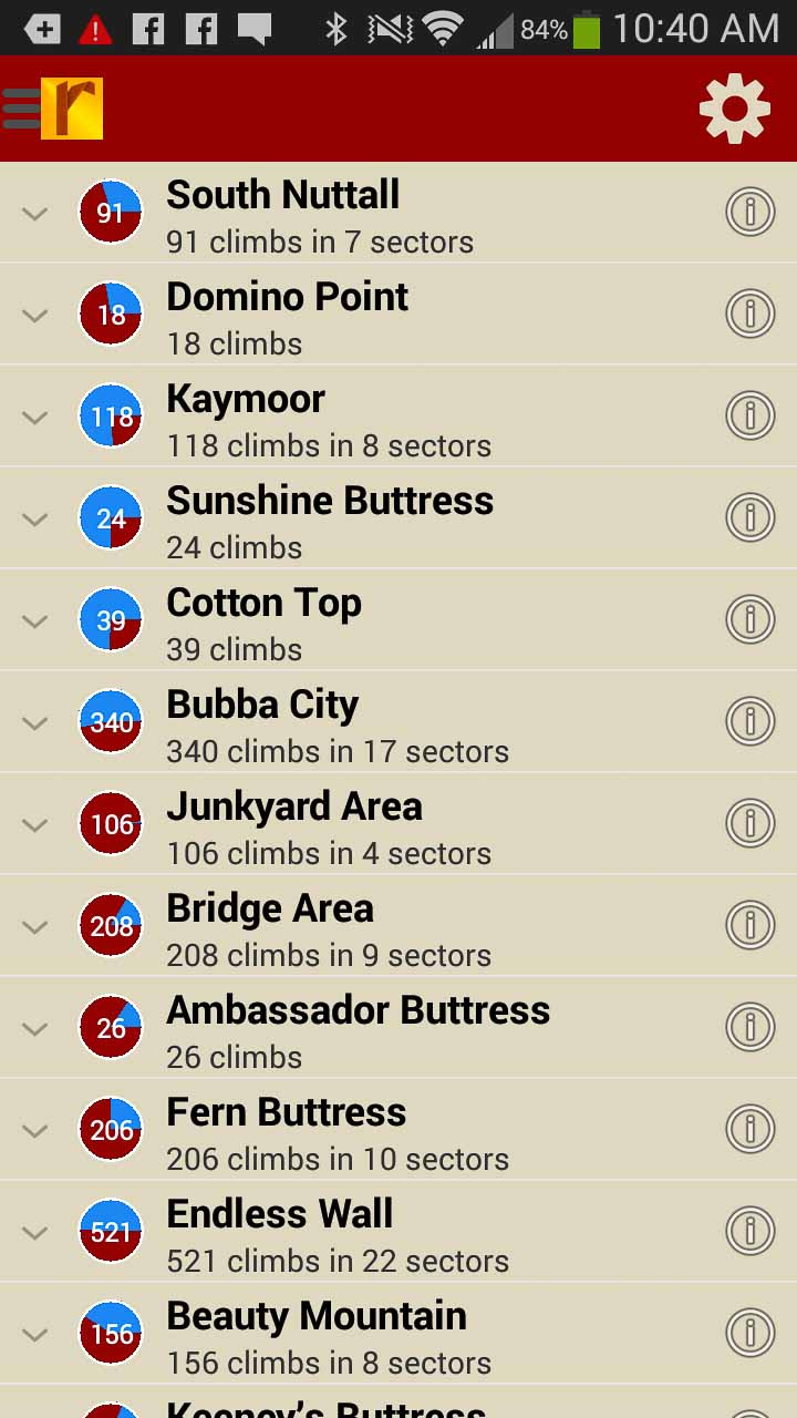
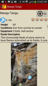
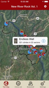
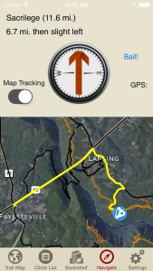
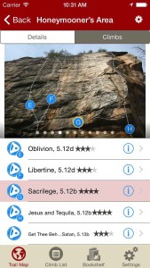
New River Rock Vol. 1
Wolverine Publishing
by Mike Williams Mike’s Iron Clad Beta Blog
The New River Gorge National River encompasses a 53-mile corridor of scenic waterway through West Virginia’s Appalachian Mountains and is home to one of America’s best and biggest rock-climbing areas. The variety of routes is unparalleled with everything from traditionally protected splitter cracks and technical face climbs to overhanging sport routes. This digital guidebook (more up to date than print) documents more than 1900 climbing routes found along the immaculate sandstone walls of this beautiful gorge. Entertaining route descriptions, full color photos, complete trail map enabling turn-by-turn navigation to the crag and up-to-date beta are all found in the best New River digital guide ever created.
Print + digital bundle pricing includes $6.00 for shipping.
Don’t forget to check New River Rock Vol. 2 for more coverage of this amazing area!
-
-
Explore the New River Gorge like it was meant to be explored via our interactive trail map.
-
-
Then just like Mike Williams was showing you how to get to his latest secret project, rakkup guides you car to crag then shows you a picture when you arrive. Awesome.
-
-
Tap on a climb name, see where it’s located on the image. Tap on a climb bubble in the image, discover what climb it is. So nice…
-
-
Over 1800 New River Gorge climbs at your fingertips.
-
-
Too much to handle? Sort all those climbs to only the grades you want to see. Too hot? No prob, filter by in shade only.
-
-
Tired of bad beta? Use local expert, Mike William’s beta to send your next proj!